


Downpour deluge to hit UK as Met Office issues nine-hour rain weather warning for 40 areas - with up to 70mm feared in some places
The UK is bracing itself for a deluge of rain after the Met Office issued a nine-hour weather warning for 40 areas.
The yellow weather warning was issued across parts of southern England and south Wales, with up to 70mm expected in some areas.
It is in force from 6pm today until 3am tomorrow and covers areas including Hampshire, Oxfordshire, Gloucestershire, Cardiff, Devon and Cornwall.
The Met Office said people in the affected areas should expect longer bus and train journey times, spray and flooding on roads and some interruption to power supplies.
Most of the warning area will see around 20 to 40mm of rain, while areas such as Dartmoor and Exmoor could see up to 70mm.
MailOnline has published a full list of the areas covered by the rain warning below.

It's been a wet and misty start to the day in Dunsden, Oxfordshire
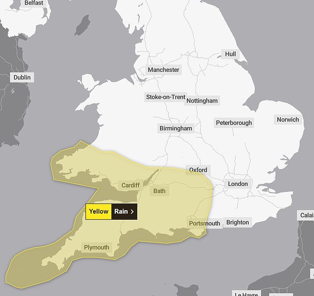
A yellow weather warning for rain has been issued across parts of southern England and south Wales, with up to 70mm expected in some areas

The sunrise over Glastonbury Tor in Somerset this morning

Today, sunny spells and showers will continue across northern areas and it will turn wet and windy further south. Pictured is the Met Office map
The position of the jet stream across the middle of the country is the reason for the current unsettled spell due to low pressure forming in the troughs.
Despite the Met Office forecasting warmer temperatures this week reaching 22C, the recent spate of heavy rain which has dampened the summer spirit entering July isn't over yet.
The Met Office states: 'After a generally cloudy day with showers, more persistent rain will push north this evening and overnight.
'Rain will be persistent and heavy at times, particularly so for hills, moors and headlands exposed to brisk winds.'
It comes after last month was one of the coldest Junes since 2015, with Brits wistfully awaiting news of a heatwave.
Today, sunny spells and showers will continue across northern areas and it will turn wet and windy further south - with four flood warnings in place near London.
The Met Office said this afternoon could see 'isolated thunder' in the afternoon but those in central parts will see a much 'brighter day'.
But later in the month, the weather is set to improve, allowing Brits to have a break from the downpours as it becomes 'mostly dry' with 'light winds and sunshine'.
The long range forecast predicts: 'Many areas should start this period mostly dry as a ridge of high pressure dominates the UK.
'It should feel pleasant enough in mostly light winds and sunshine, with temperatures generally near average, but some rural areas could experience chilly nights. However there is also a chance that rain may fringe into easternmost and southwesternmost areas at times.
'Then a transition to more generally changeable conditions looks most likely, though with a northwest-southeast split in fortunes.
'Northwestern areas will probably see more in the way of cloud and rain, whereas southeastern parts stand a better chance of longer periods of drier and at times, somewhat warmer weather.
'However, some rain may extend further southeast across all parts of the UK from time to time.'
But before the weather is set to improve, a second yellow weather warning for rain has been issued across northern Scotland, with up to 90mm of rainfall expected in the worst affected areas.
The warning, which is in place from 10pm on Tuesday until 11.59pm on Wednesday, covers areas including Angus, Aberdeenshire, Moray and the Highlands.
The Met Office said those in the affected areas should expect some communities to be cut off by flooded roads, difficult driving conditions because of flooding and spray, and fast flowing or deep floodwater which could cause a danger to life.
Delays and cancellations to public transport should also be expected, the forecaster said.
Most of the warning area will see between 20mm and 30mm of rain, with localised heavier bursts likely to increase totals to around 50-75mm.
Up to 90mm is possible across Grampian and the north-west Highlands.
The upcoming weather follows Wimbledon and Henley being soaked over the weekend with the occasional booms of thunder heard.
The Henley Royal Regatta, Wimbledon and the Grand Prix were all affected by the downpours.
Henley guests on the River Thames were spotted in waterproof ponchos and umbrellas as they scrambled to find places to let their hoods down.
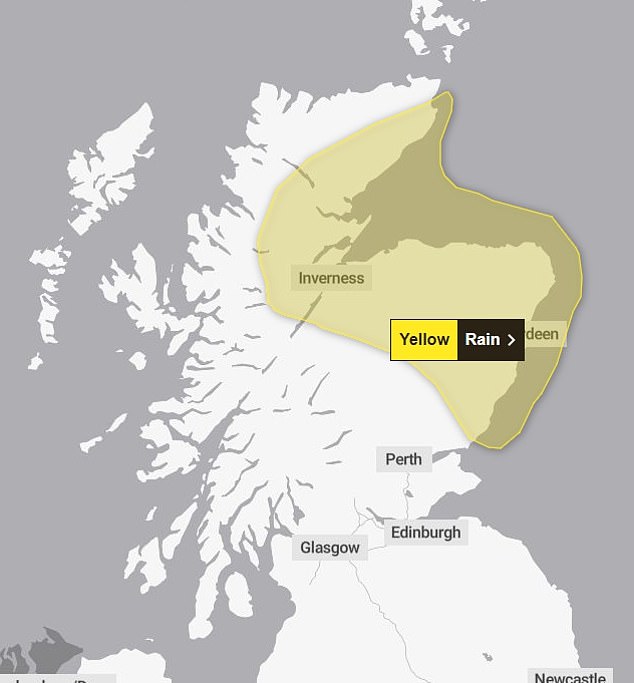
A second yellow weather warning for rain has been issued in Scotland from 10pm on Tuesday until 11.59pm on Wednesday, covering areas including Angus, Aberdeenshire, Moray and the Highlands

The sunrise over Portsmouth and the Spinnaker Tower in Hampshire this morning at 5am
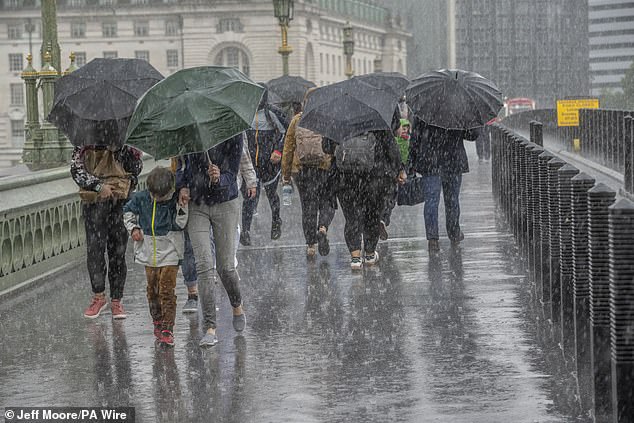
People run for cover from the heavy rain in Westminster yesterday

Spectators on day seven of the 2024 Wimbledon Championships shelter from the rain July 7

Rowing fans shelter from the rain underneath their umbrellas at Henley yesterday

Spectators with umbrellas ahead of the race at Silverstone Circuit, yesterday
Racegoers got soaked in the tumultuous British summer weather. Many were making makeshift parasols out of their blazers, as others huddled together to hide from the rain.
However, earlier the skies looked to be more forgiving, giving guests a chance to show off their stylings.
It was a similar situation for guests at Wimbledon as they sat huddled under their umbrellas and waited patiently for the start of play. Scattered showers have plagued the tournament ever since it began last week.
Grand Prix attendees could be seen donning raincoats and umbrellas ahead of the race at Silverstone Circuit.