Strike-slip tectonics or wrench tectonics is a type of tectonics that is dominated by lateral (horizontal) movements within the Earth's crust. Where a zone of strike-slip tectonics forms the boundary between two tectonic plates, this is known as a transform or conservative plate boundary. Areas of strike-slip tectonics are characterised by particular deformation styles including: stepovers, Riedel shears, flower structures and strike-slip duplexes. Where the displacement along a zone of strike-slip deviates from parallelism with the zone itself, the style becomes either transpressional or transtensional depending on the sense of deviation. Strike-slip tectonics is characteristic of several geological environments, including oceanic and continental transform faults, zones of oblique collision and the deforming foreland of zones of continental collision.
In seismology, a supershear earthquake is when the propagation of the rupture along the fault surface occurs at speeds in excess of the seismic shear wave velocity. This causes an effect analogous to a sonic boom.

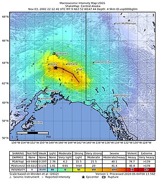
The 2002 Denali earthquake occurred at 22:12:41 UTC November 3 with an epicenter 66 km ESE of Denali National Park, Alaska, United States. This 7.9 Mw earthquake was the largest recorded in the United States in 37 years. The shock was the strongest ever recorded in the interior of Alaska. Due to the remote location, there were no fatalities and only one injury.
The 2010 Yushu earthquake struck on April 14 and registered a magnitude of 6.9 Mw or 7.1 Ms. It originated in Yushu, Qinghai, China, at 7:49 am local time. According to the Xinhua News Agency, 2,698 people were confirmed dead, 270 missing and 12,135 injured, 1,434 of them severely. The epicenter was located in Rima village (日玛村/日麻村), Upper Laxiu township (上拉秀乡) of Yushu County, in remote and rugged terrain, near the border of Tibet Autonomous Region, about 30 km from Gyêgu town or Jyekundo, the seat of Yushu County, and about 240 km from Qamdo. The epicenter was in a sparsely populated area on the Tibetan plateau that is regularly hit by earthquakes.

The Kunlun Fault is a major active left-lateral strike-slip fault to the north side of Tibet. Slippage along the 1,500-kilometre-long (930 mi) fault has occurred at a constant rate for the last 40,000 years. This has resulted in a cumulative offset of more than 400 metres (1,300 ft). The fault is seismically active, most recently causing the magnitude 7.8 2001 Kunlun earthquake. It forms the northeastern boundary of the elongate wedge of the Tibetan Plateau known as the Bayan Har block.
The 1932 Changma earthquake occurred at 10:04:27 local time on 25 December. With an estimated magnitude of 7.6 on the surface-wave magnitude scale, and a maximum felt intensity of X (Extreme) on the Mercalli intensity scale, the quake destroyed 1,167 houses and caused 275 to 70,000 deaths and 320 injuries.

In seismology, a tsunami earthquake is an earthquake which triggers a tsunami of significantly greater magnitude, as measured by shorter-period seismic waves. The term was introduced by Japanese seismologist Hiroo Kanamori in 1972. Such events are a result of relatively slow rupture velocities. They are particularly dangerous as a large tsunami may arrive at a coastline with little or no warning.
In seismology, an earthquake rupture is the extent of slip that occurs during an earthquake in the Earth's crust. Earthquakes occur for many reasons that include: landslides, movement of magma in a volcano, the formation of a new fault, or, most commonly of all, a slip on an existing fault.

The Xianshuihe fault system or the Yushu-Ganzi-Xianshuihe fault system is a major active sinistral (left-lateral) strike-slip fault zone in southwestern China, at the eastern edge of the Tibetan Plateau. It has been responsible for many major earthquakes, and is one of the most seismically active fault zones in China.
An earthquake occurred in southern Mongolia on December 4, 1957, measuring 7.8–8.1 and assigned XII (Extreme) on the Modified Mercalli intensity scale. Surface faulting was observed in the aftermath with peak vertical and horizontal scarp reaching 9 m (30 ft). Because of the extremely sparse population in the area, this event, despite its magnitude, was not catastrophic. However, 30 people died and the towns of Dzun Bogd, Bayan-leg and Baruin Bogd were completely destroyed.

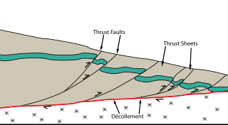
The Main Himalayan Thrust (MHT) is a décollement under the Himalaya Range. This thrust fault follows a NW-SE strike, reminiscent of an arc, and gently dips about 10 degrees towards the north, beneath the region. It is the largest active continental megathrust fault in the world.

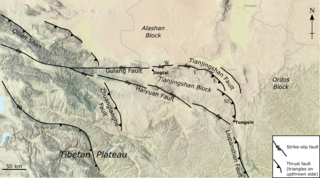
The Haiyuan Fault is a major active intracontinental strike-slip (sinistral) fault in Central Asia.
On July 18, 2017, an earthquake struck near the Komandorski Islands, east of the Kamchatka Peninsula in the Bering Sea at 11:34 local time. Although there were no casualties from this earthquake, it was notable for a rare characteristic known as supershear, and is one of the few times a large supershear earthquake has been observed. It was preceded by a few foreshocks months earlier, and aftershocks that continued for nearly six months.

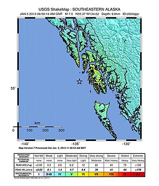
The 2013 Craig, Alaska earthquake struck on January 5, at 12:58 am (UTC–7) near the city of Craig and Hydaburg, on Prince of Wales Island. The Mw 7.5 earthquake came nearly three months after an Mw 7.8 quake struck Haida Gwaii on October 28, in 2012. The quake prompted a regional tsunami warning to British Columbia and Alaska, but it was later cancelled. Due to the remote location of the quake, there were no reports of casualties or damage.
The 1902 Turkestan earthquake devastated Xinjiang, China, near the Kyrgyzstan border. It occurred on August 22, 1902, at 03:00:22 with an epicenter in the Tien Shan mountains. The thrust earthquake measured 7.7 on the moment magnitude scale (Mw ) and had a depth of 18 km (11 mi).
The 1906 Manasi earthquake (玛纳斯地震), also known as the Manas earthquake occurred in the morning of December 23, 1906, at 02:21 UTC+8:00 local time or December 22, 18:21 UTC. It measured 8.0–8.3 on the moment magnitude scale and 8.3 on the surface-wave magnitude scale. The epicenter of this earthquake is located in Manas County, Xinjiang, China. An estimated 280–300 people died and another 1,000 more were injured by the earthquake.
The 1990 Gonghe earthquake occurred on April 26 at 17:37 China Standard Time in Hainan Tibetan Autonomous Prefecture, Qinghai Province. The mainshock had a surface wave magnitude of 7.0 Ms and a moment magnitude of 6.5 Mw . It was presaged by two foreshocks that struck merely seconds before the main earthquake. On the Mercalli intensity scale, the earthquake had a rating of IX (Violent).
The 2021 Maduo earthquake, also known as the 5.22 earthquake struck Madoi County in Qinghai Province, China on 22 May at 02:04 local time. The earthquake had a moment magnitude and surface-wave magnitude of 7.4. Highway bridges, roads and walls collapsed as a result of the earthquake. According to an anonymous source, at least 20 people were killed, 300 were injured, and 13 were missing. Officials stated that there were no deaths but 19 people sustained minor injuries. It was the strongest in China since 2008. It was assigned a maximum intensity of X in Machali, Maduo County on the China seismic intensity scale and Modified Mercalli intensity scale. This earthquake was preceded by another unrelated earthquake that occurred 5 hours earlier in Yunnan.
The 1995 Menglian earthquake or 1995 Myanmar–China earthquake occurred on 12 July at 05:46:43 local time in the Myanmar–China border region. The earthquake had an epicenter on the Myanmar side of the border, located in the mountainous region of Shan State. It registered 7.3 on the Chinese surface-wave magnitude scale (Ms ) and 6.8 on the moment magnitude scale (Mw ). With a maximum Mercalli intensity assigned at VIII, it killed 11 people and left another 136 injured. Over 100,000 homes in both countries were destroyed and 42,000 seriously damaged. Some damage to structures were also reported in Chiang Mai and Chiang Rai, Thailand. The low death toll from this earthquake was attributed to an early warning issued prior to it happening. Precursor events including foreshocks and some seismic anomalies led to an evacuation of the area before the mainshock struck. It is thought to be one of the few successfully predicted earthquakes in history.
The 1850 Xichang earthquake rocked Sichuan Province of Qing China on September 12. The earthquake which caused major damage in Xichang county had an estimated moment magnitude of 7.3–7.9 Mw and a surface wave magnitude of 7.5–7.7 Ms . An estimated 20,650 people died.


