1975 Haicheng earthquake

Last updated
1975 Haicheng earthquake
China edcp relief location map.jpg
Bullseye1.png
UTC  time1975-02-04 11:36:06
ISC  event 731961
USGS-ANSS ComCat
Local dateFebruary 4, 1975
Local time19:36 CST
Magnitude7.0 Mw
7.5 Ms
6.2 mb [1]
Depth15.6 km
Epicenter 40°40′N122°41′E / 40.66°N 122.68°E / 40.66; 122.68
Max. intensity MMI IX (Violent)
TsunamiNone
Casualties1,328–2,041 killed [2]

On February 4, 1975, at 19:36 CST, an earthquake of Ms 7.5 and intensity (MMI) IX hit the city of Haicheng, Liaoning, China. Much of the city was evacuated before the earthquake, so few died from building collapse; however, many died from fire and hypothermia in the subsequent days. The evacuees lived during the deep winter in self-made tents made of tree branches, bed sheets, tarps and straw, [3] 372 froze to death and 6,578 suffered frostbite, [4] while a fire burned 341 to death and 980 suffered non-fatal burns. [4] The fire was one of the most notable earthquake-induced fires in China, triggered from a combination of cooking, winter heating and lighting.

Contents

The early evacuation ordered by Chinese officials had been questioned to whether it was a scientific earthquake prediction or a fluke. The prediction was based mainly on the pronounced foreshock sequence. [5] None of the precursors observed in this earthquake were observed in the 1976 Tangshan earthquake, which killed over 240,000. [5] This prediction was later put under heavy scrutiny and was deemed a fluke.[ who? ]

Tectonic setting

Leading up to the earthquake in 1975, there were multiple large earthquakes that occurred in three years all due to right-lateral motion of north northeast-trending strike-slip faults, they also appeared to have migrated from southwest to northeast. These were the three earthquakes of M 6.8, 6.7, and 7.2 in the Xingtai area in March 1966, the M 6.7 Hejian earthquake of 1967, and the M 7.4 Bohai Sea earthquake of 1969. [6] These interpretations are believed to be tied into the Geomechanics Theory of Li Siguang. The theory states "that north-northeast China is part of an integral geological system characterized by neotectonic right-lateral motion along north-northeast trending structures", [6] in other terms, this relates to the deformation of the Eurasian plate with an east–west compressive stress regime which was caused by continental collision at the Himalaya and plate subduction along the Japan–Kuril trenches. There is a belief among scientist that the early earthquakes in North China set off the large system and led to more earthquakes later on.

Evacuation

A low-level alert was triggered by regional increases in seismicity (later recognized as foreshocks). Both authorities and citizens were finally placed on high alert and an evacuation order was issued due to an increase in foreshocks. Though this particular prediction of the earthquake was initially believed to be just the latest in a recent string of false alarms that had occurred in the preceding months, including one case of an earthquake swarm being caused by the filling of a reservoir, the evacuation of Haicheng proceeded anyway and eventually paid off.

The evacuation, despite successfully removing most of Haicheng's population, did not prevent deaths in its entirety. When the main quake struck at 7:36 pm, a reported 2,041 people died, over 27,000 were injured and thousands of buildings collapsed. However, the death toll was much lower than the estimate of over 150,000 dead which is believed to have resulted if the evacuation had not taken place. This was the only successful evacuation of a potentially affected population before a devastating earthquake in history.

Fatalities

Much of the city was evacuated before the earthquake, so few died from building collapse, however, many died from fire and hypothermia in the subsequent days. The evacuees lived during the deep winter in self-made tents made of tree branches, bed sheets, tarps and straw, [3] 372 froze to death and 6,578 suffered frostbite, [4] while a fire burned 341 to death and 980 suffered non-fatal burns. [4] The fire was one of the most notable earthquake-induced fires in China, triggered from a combination of cooking, winter heating and lighting.

Damage

The earthquake's close proximity to a city of one million residents caused a large amount of destruction to infrastructure and property. Haicheng was decimated by this earthquake as the intensity was too great for the buildings to withstand. There was mass building collapse throughout the area as well as the destruction of cultivated land, roads, highways, and railways. It is approximated that 90% of the structures in Haicheng at the time experienced significant damage or were completely destroyed by the earthquake. Local bridges collapsed and oil transport pipelines were damaged. Unfortunately, due to the political climate in China at the time, exact damage totals are unknown. [7]

However, damage was reported as far away as South Korea and Japan. Due to the distance between these areas and the epicenter of the quake, the damage were significantly less in number and in degree. In Seoul, South Korea, the MMI was calculated to be a IV in comparison to Haicheng where the MMI was determined to be IX. In contrast to mass building collapse in Haicheng, there were a few reports of smaller buildings collapsing partially as well as intense shaking of high rise buildings. Interruption of electrical service was also reported due to transformer tripping that is attributed to long-period seismic waves from the high magnitude earthquake being able to travel far distances. [8]

Earthquake prediction

The early evacuation ordered by Chinese officials had been questioned to whether it was a scientific earthquake prediction or a fluke. The Chinese traced their predictions to as early as 1970. A team of scientists from the U.S. visited laboratories in China in 1976 to investigate the Haicheng prediction. Their report concluded that the 1975 Haicheng prediction was based mainly on the pronounced foreshock sequence. Due to these foreshocks, some of the final evacuation orders were given only hours before the destructive earthquake preventing further loss of life. This "prediction" was later put under heavy scrutiny and was deemed as a fluke.

This prediction and evacuation saved countless lives, limiting the total fatalities to under 2,500 and total injuries to 27,500 people. The estimated number of injured and deceased individuals without the implementation of the evacuation skyrockets: estimating that over 150,000 [5] people could have been injured without a successful evacuation. None of the precursors observed in this earthquake were observed in the 1976 Tangshan earthquake, which killed over 240,000. [9]

1970

After the occurrence of a number of large earthquakes from 1966 to 1969, a meeting was held nationally to discuss where the largest seismic danger was in the People's Republic of China. These large earthquakes were determined to be moving to the North East, and it was also discussed that there would be a large earthquake of magnitude 5–6 at least along the Pohai Gulf. The prominent faults in the area determined to be the danger were the Jinzhou, Zhuanghe, and Yalu River faults, which were all prominent North-Northeast striking faults. There was then a large increase in scientific investigation in the surrounding province of Liaoning, as well as many new seismic stations, due to the long-range prediction. [10]

June 1974

After four years of data collection the meeting was brought back together to determine a new prediction. They believed that the magnitude 5–6 earthquake they had predicted in 1970 would now occur within the next 2 years in the northern part of the Pohai Gulf. Severely increased microearthquake activity as well as levelling and short level lines data assisted in the new prediction decision. The scientific examinations in the area were increased significantly and a large education campaign was initiated to inform the public on earthquake safety and the hazards of earthquakes. [10]

December 1974

There was a series of earthquakes in the area of Liaoyang, an area of usually low seismicity, the largest of which had a magnitude of 4.8. These quakes prompted the Revolutionary Committee of the Liaoning Province to issue alerts of a possible large earthquake in the near future. Reports of odd animal behavior and changes in ground water levels increased in the area into 1975. [10]

Foreshocks

The prediction was further updated to be a magnitude 5.5–6 earthquake in the first half of 1975, likely due to the series of quakes at the end of 1974 as well as the observations of animals and groundwater. The foreshocks of the Haicheng earthquake then began on February 1, 1975, and continued into February 3. There were foreshocks of magnitudes greater than 4, which were felt throughout the province. The reports of odd behavior of water wells and animals began to migrate towards Haicheng at this time as well. Anomalies of radon emissions, electrical resistivity, and a tilt anomaly also occurred. All of this data led to the conclusion that the earthquake would occur within the next two days. Emergency measures were then taken to prevent loss of life. [10]

Natural occurrences and earthquake prediction

The study of declassified Chinese documents as well as interviews with witnesses have revealed the other occurrences considered by the People's Republic of China's National Earthquake Research Program when predicting the Haicheng earthquake. While these anomalies are not always indicators of a major earthquake to occur, they were all taken into account during the prediction of the Haicheng earthquake. These anomalies include ground surface deformation, changes in groundwater (including changes in level, color, and chemistry), and unusual animal behavior.

Ground surface deformation

Ground surface deformation, also known as geodetic deformation, occurred both before and after the Haicheng earthquake. Dating back to decades before the earthquake, geodetic deformation was observed in the form of vertical crustal movements in a broad area around the general region of where the earthquake struck in 1975. The epicenter of the earthquake happened to fall where two of these steep vertical crusts intersect.

Another instance of ground surface deformation that was taken into account when predicting the earthquake was data recorded by the Jin Xian station 18 months before the quake occurred that was located only 200 kilometers from the epicenter of the earthquake. This data encompassed many stages of crustal deformation. This began with recording the initial, stable state, of the ground surface in the area. Tilting of the ground in one direction was then recorded, following by the recording of the ground tilting in the opposite direction. Stages of rapid to slow tilting were also observed. These data sets provided basis for intermediate and short-term predictions for the Haicheng earthquake.

Changes in groundwater

Water wells, which were monitored closely, saw increasingly significant fluctuations in their water levels until the earthquake occurred in February 1975.

Unusual animal behavior

Another sign of the earthquake coming was the unusual animal behavior. In December 1974, rats and snakes appeared "frozen" on the roads. Starting in February 1975 reports of this type increased greatly. Cows and horses looked restless and agitated. Rats appeared "drunk", chickens refused to enter their coops and geese frequently took to flight.

Earthquake prediction scrutiny

In recent years, the success of the earthquake's prediction has come under scrutiny. Seismologists have agreed that the Haicheng earthquake can't be looked to as any sort of "prototype" for predicting future earthquakes, as the foreshocks that played a huge role in leading to prediction of this earthquake are not a regular, reliable occurrence before all earthquakes. However, Qi-Fu Chen, a research professor at Beijing's China Earthquake Administration, explained that this earthquake at least "showed the importance of public education," prompting a further discussion about the necessity of making the public aware of the dangers, preparations, and warning signs related to earthquakes. [11]

It is still a topic of debate, however, whether there is any merit whatsoever in the prediction. Until recently, there were no details given of the evacuation, which led to many scientists questioning the success of the prediction. The suspicion began were a lack of written records but increased due to the time period being during the cultural revolution, which was a period where gaining accurate information from China was extremely difficult.

This earthquake hit the nearby city of Tangshan and none of the foreshocks or other phenomena which were present before the Haicheng earthquake were observed prior to this incident. This second earthquake showed that the prediction of Haicheng's earthquake and subsequent evacuation was likely a fluke incident. [9]

See also

Related Research Articles

<span class="mw-page-title-main">Earthquake</span> Sudden movement of the Earths crust

An earthquake – also called a quake, tremor, or temblor – is the shaking of the Earth's surface resulting from a sudden release of energy in the lithosphere that creates seismic waves. Earthquakes can range in intensity, from those so weak they cannot be felt, to those violent enough to propel objects and people into the air, damage critical infrastructure, and wreak destruction across entire cities. The seismic activity of an area is the frequency, type, and size of earthquakes experienced over a particular time. The seismicity at a particular location in the Earth is the average rate of seismic energy release per unit volume.

The Modified Mercalli intensity scale measures the effects of an earthquake at a given location. This is in contrast with the seismic magnitude usually reported for an earthquake.

Earthquake prediction is a branch of the science of seismology concerned with the specification of the time, location, and magnitude of future earthquakes within stated limits, and particularly "the determination of parameters for the next strong earthquake to occur in a region". Earthquake prediction is sometimes distinguished from earthquake forecasting, which can be defined as the probabilistic assessment of general earthquake hazard, including the frequency and magnitude of damaging earthquakes in a given area over years or decades.

In seismology, an aftershock is a smaller earthquake that follows a larger earthquake, in the same area of the main shock, caused as the displaced crust adjusts to the effects of the main shock. Large earthquakes can have hundreds to thousands of instrumentally detectable aftershocks, which steadily decrease in magnitude and frequency according to a consistent pattern. In some earthquakes the main rupture happens in two or more steps, resulting in multiple main shocks. These are known as doublet earthquakes, and in general can be distinguished from aftershocks in having similar magnitudes and nearly identical seismic waveforms.
<span class="mw-page-title-main">New Madrid seismic zone</span> Major seismic zone in the southern and midwestern United States

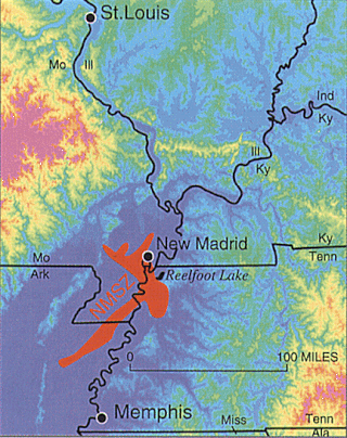
The New Madrid seismic zone (NMSZ), sometimes called the New Madrid fault line, is a major seismic zone and a prolific source of intraplate earthquakes in the Southern and Midwestern United States, stretching to the southwest from New Madrid, Missouri.

<span class="mw-page-title-main">Parkfield earthquake</span> Series of earthquakes in California, US

Parkfield earthquake is a name given to various large earthquakes that occurred in the vicinity of the town of Parkfield, California, United States. The San Andreas fault runs through this town, and six successive magnitude 6 earthquakes occurred on the fault at unusually regular intervals, between 12 and 32 years apart, between 1857 and 1966. The latest major earthquake in the region struck on September 28, 2004.

A foreshock is an earthquake that occurs before a larger seismic event – the mainshock – and is related to it in both time and space. The designation of an earthquake as foreshock, mainshock or aftershock is only possible after the full sequence of events has happened.

The 1857 Fort Tejon earthquake occurred at about 8:20 a.m. on January 9 in central and Southern California. One of the largest recorded earthquakes in the United States, with an estimated moment magnitude of 7.9, it ruptured the southern part of the San Andreas Fault for a length of about 225 miles, between Parkfield and Wrightwood.
<span class="mw-page-title-main">1976 Tangshan earthquake</span> Mw 7.6 earthquake in Hebei, China

The 1976 Tangshan earthquake was a Mw 7.6 earthquake that hit the region around Tangshan, Hebei, China, at 3:42 a.m. on 28 July 1976. The maximum intensity of the earthquake was XI (Extreme) on the Mercalli scale. In minutes, 85 percent of the buildings in Tangshan collapsed or were rendered unusable, all services failed, and most of the highway and railway bridges collapsed or were seriously damaged. The official count stated 242,469 deaths, while historians accepted at least 300,000 died, making it the deadliest earthquake in recorded history and one of the worst disasters in China by death toll.

Earthquake forecasting is a branch of the science of seismology concerned with the probabilistic assessment of general earthquake seismic hazard, including the frequency and magnitude of damaging earthquakes in a given area over years or decades. While forecasting is usually considered to be a type of prediction, earthquake forecasting is often differentiated from earthquake prediction, Earthquake forecasting estimates the likelihood of earthquakes in a specific timeframe and region, while earthquake prediction attempts to pinpoint the exact time, location, and magnitude of an impending quake, which is currently not reliably achievable.Wood & Gutenberg (1935). Kagan says: "This definition has several defects which contribute to confusion and difficulty in prediction research." In addition to specification of time, location, and magnitude, Allen suggested three other requirements: 4) indication of the author's confidence in the prediction, 5) the chance of an earthquake occurring anyway as a random event, and 6) publication in a form that gives failures the same visibility as successes. Kagan & Knopoff define prediction "to be a formal rule where by the available space-time-seismic moment manifold of earthquake occurrence is significantly contracted ...."</ref> Both forecasting and prediction of earthquakes are distinguished from earthquake warning systems, which, upon detection of an earthquake, provide a real-time warning to regions that might be affected.

<span class="mw-page-title-main">Lucy Jones</span> American seismologist

Lucile M. Jones is an American seismologist and public voice for earthquake science and earthquake safety in California. One of the foremost and trusted public authorities on earthquakes, Jones is viewed by many in Southern California as "the Beyoncé of earthquakes" who is frequently called upon to provide information on recent earthquakes.

<span class="mw-page-title-main">2008 Sichuan earthquake</span> Magnitude 8.0 earthquake in China

An earthquake occurred in the province of Sichuan, China at 14:28:01 China Standard Time on May 12, 2008. Measuring at 8.0 Ms, the earthquake's epicenter was located 80 kilometres (50 mi) west-northwest of Chengdu, the provincial capital, with a focal depth of 19 km (12 mi). The earthquake ruptured the fault for over 240 km (150 mi), with surface displacements of several meters. The earthquake was also felt as far away as Beijing and Shanghai—1,500 and 1,700 km away, respectively—where office buildings swayed with the tremor, as well as Bangkok, Thailand and Hanoi, Vietnam. Strong aftershocks, some exceeding 6 Ms, continued to hit the area up to several months after the main shock, causing further casualties and damage. The earthquake also caused the largest number of geohazards ever recorded, including about 200,000 landslides and more than 800 quake lakes distributed over an area of 110,000 km2 (42,000 sq mi).

<span class="mw-page-title-main">Tōkai earthquakes</span> Class of earthquakes in Japan

The Tōkai earthquakes are major earthquakes that have occurred regularly with a return period of 100 to 150 years in the Tōkai region of Japan. The Tōkai segment has been struck by earthquakes in 1498, 1605, 1707, and 1854. Given the historic regularity of these earthquakes, Kiyoo Mogi in 1969 pointed out that another great shallow earthquake was possible in the "near future".

Kiyoo Mogi was a prominent seismologist. He was regarded as Japan's foremost authority on earthquake prediction and was a chair of the Japanese Coordinating Committee for Earthquake Prediction (CCEP). Mogi was also a director of the University of Tokyo's Earthquake Research Institute, a professor at Nihon University and a professor emeritus at Tokyo University. Due to the seismic activity in Japan, Mogi also took an interest in the safety of nuclear power in Japan.

The 1932 Jalisco earthquakes began on June 3 at 10:36 UTC with a megathrust event that registered 8.1 on the moment magnitude scale. With a maximum perceived intensity of X (Extreme) on the Mercalli intensity scale, at least 400 deaths were caused in Mexico and neighboring Guatemala. It was the first of a series of seismic events that affected parts of western Mexico during the month of June 1932, all reaching magnitude 7 or greater.

The 2019 Ridgecrest earthquakes of July 4 and 5 occurred north and northeast of the town of Ridgecrest, California, located in Kern County and west of Searles Valley. They included three initial main shocks of Mw magnitudes 6.4, 5.4, and 7.1, and many perceptible aftershocks, mainly within the area of the Naval Air Weapons Station China Lake. Eleven months later, a Mw  5.5 aftershock took place to the east of Ridgecrest. The first main shock occurred on Thursday, July 4 at 10:33 a.m. PDT, approximately 18 km (11.2 mi) ENE of Ridgecrest, and 13 km (8.1 mi) WSW of Trona, on a previously unnoticed NE-SW trending fault where it intersects the NW-SE trending Little Lake Fault Zone. This quake was preceded by several smaller earthquakes, and was followed by more than 1,400 detected aftershocks. The M 5.4 and M 7.1 quakes struck on Friday, July 5 at 4:08 a.m. and 8:19 p.m. PDT approximately 10 km (6 miles) to the northwest. The latter, now considered the mainshock, was the most powerful earthquake to occur in the state in 20 years. Subsequent aftershocks extended approximately 50 km (~30 miles) along the Little Lake Fault Zone.

The 1995 Menglian earthquake or 1995 Myanmar–China earthquake occurred on 12 July at 05:46:43 local time in the Myanmar–China border region. The earthquake had an epicenter on the Myanmar side of the border, located in the mountainous region of Shan State. It registered 7.3 on the Chinese surface-wave magnitude scale (Ms ) and 6.8 on the moment magnitude scale (Mw ). With a maximum Mercalli intensity assigned at VIII, it killed 11 people and left another 136 injured. Over 100,000 homes in both countries were destroyed and 42,000 seriously damaged. Some damage to structures were also reported in Chiang Mai and Chiang Rai, Thailand. The low death toll from this earthquake was attributed to an early warning issued prior to it happening. Precursor events including foreshocks and some seismic anomalies led to an evacuation of the area before the mainshock struck. It is thought to be one of the few successfully predicted earthquakes in history.

The 1990 Carlentini earthquake occurred off the Sicilian coast, 20 km east northeast from the town of Augusta, Sicily on 13 December at 01:24 local time. The moderately-sized earthquake measuring 5.6 on the moment magnitude scale (Mw ) resulted in the deaths of 19 people and caused at least 200 injuries. It also inflicted significant damage in the region, leaving 2,500 homeless.

The 1985 Kayrakkum earthquake struck Soviet Tajikistan on October 13 at about 22:00 local time. The earthquake measured Mw  5.8 and struck at a depth of 17.1 km (10.6 mi). At least 29 people died, over 80 were injured and another 8,000 were made homeless. Damage totaled $US200 million. Figures of the casualties were not disclosed until the following month.

References

  1. International Seismological Centre. ISC-EHB Bulletin. Thatcham, United Kingdom.[Event  731961 ].
  2. "Earthquake Prediction: Haicheng, China – 1975". Eserc.stonybrook.edu. Archived from the original on 2016-03-18. Retrieved 2016-01-14.[ better source needed ]
  3. 1 2 Photos of such tents taken in 1976 can be found in: 吴彦君 (2012). "我家的防震棚" [The earthquake tents at my home]. In 阿滢 (ed.). 秋缘斋读书记. 天地出版社. Archived from the original on 2022-01-01.
  4. 1 2 3 4 颤抖的地球—地震科学 (2005). Researched by CEA seismologists 冯万鹏,薑文亮,龚丽霞,公茂盛,胡进军; Revised by CEA seismologists 王文清,续春荣,张宝红; Edited by CEA chiefs 谢礼立,张景发. Tsinghua University Press. Pages XIII, 162.
  5. 1 2 3 "Repeating Earthquakes". United States Geological Survey. Retrieved 2021-11-03.
  6. 1 2 Kelin Wang, Qi-Fu Chen, Shihong Sun, Andong Wang; Predicting the 1975 Haicheng Earthquake. Bulletin of the Seismological Society of America 2006; 96 (3): 757–795. doi : 10.1785/0120050191
  7. Wang, K. (2006-06-01). "Predicting the 1975 Haicheng Earthquake". Bulletin of the Seismological Society of America. 96 (3): 757–795. Bibcode:2006BuSSA..96..757W. doi:10.1785/0120050191. ISSN   0037-1106.
  8. Li, Yü-che; Chu, Kyo-Sung; Ishikawa, Yuzo (2007-03-01). "Damage of 1975 Haicheng MS7.3 earthquake in the Korean Peninsula and its effect on Kyushu, Japan". Acta Seismologica Sinica. 20 (2): 224–233. Bibcode:2007AcSSn..20..224L. doi:10.1007/s11589-007-0224-7. ISSN   1993-1344. S2CID   129314791.
  9. 1 2 Wang, Kelin; Chen, Qi-Fu; Sun, Shihong; Wang, Andong (2006-06-01). "Predicting the 1975 Haicheng Earthquake". Bulletin of the Seismological Society of America. 96 (3): 757–795. Bibcode:2006BuSSA..96..757W. doi:10.1785/0120050191. ISSN   0037-1106.
  10. 1 2 3 4 Scholz, C. H. (May 1977). "A physical interpretation of the Haicheng earthquake prediction". Nature. 267 (5607): 121–124. Bibcode:1977Natur.267..121S. doi:10.1038/267121a0. ISSN   0028-0836. PMID   16073409. S2CID   4162356.
  11. "Prediction of the Haicheng earthquake". Eos, Transactions American Geophysical Union. 58 (5): 236–272. 1977. Bibcode:1977EOSTr..58..236.. doi:10.1029/EO058i005p00236.

Further reading