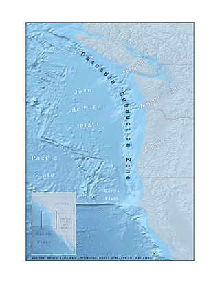
The Cascadia subduction zone is a 960 km (600 mi) fault at a convergent plate boundary, about 100–200 km (70–100 mi) off the Pacific coast, that stretches from northern Vancouver Island in Canada to Northern California in the United States. It is capable of producing 9.0+ magnitude earthquakes and tsunamis that could reach 30 m (98 ft). The Oregon Department of Emergency Management estimates shaking would last 5–7 minutes along the coast, with strength and intensity decreasing further from the epicenter. It is a very long, sloping subduction zone where the Explorer, Juan de Fuca, and Gorda plates move to the east and slide below the much larger mostly continental North American plate. The zone varies in width and lies offshore beginning near Cape Mendocino, Northern California, passing through Oregon and Washington, and terminating at about Vancouver Island in British Columbia.
The 1918 Shantou earthquake occurred in Shantou, Guangdong, Republic of China. Serious damage and high casualty numbers were reported in Guangdong and the surrounding provinces. It also caused some damage in British Hong Kong.
The 1906 Ecuador–Colombia earthquake occurred at 10:36:10 (UTC+5) on Wednesday January 31, 1906 off the coast of Ecuador, near Esmeraldas. The earthquake had a moment magnitude of 8.8 and triggered a destructive tsunami that caused at least 500 casualties on the coast of Colombia.
The 1969 Yangjiang earthquake occurred on 26 July, at 6:49 am, Beijing local time. It had a magnitude of 6.4 on the moment magnitude scale and a maximum perceived intensity of VIII (Severe) on the Mercalli intensity scale. It struck the city of Yangjiang, causing over 10,700 houses to collapse and severely damaging a further 36,000. The earthquake also caused landslides and sandblows observed along the coast and along some rivers in the area of Yangjiang. The earthquake was also felt in Hong Kong. There were an unconfirmed total of 3,000 deaths.
The 1994 Taiwan Strait earthquake occurred on 16 September 1994, at 14:20 local time in the southern Taiwan Strait. The magnitude of this earthquake was given as 6.8 by the USGS and 7.3 by Fujian Seismological Bureau. The epicenter was located about 150 to 180 km from the coast of the border of Guangdong and Fujian, and about 150 km southwest of Taiwan.
The 1932 Changma earthquake occurred at 10:04:27 local time on 25 December. With an estimated magnitude of 7.6 on the surface-wave magnitude scale, and a maximum felt intensity of X (Extreme) on the Mercalli intensity scale, the quake destroyed 1,167 houses and caused 275 to 70,000 deaths and 320 injuries.
The 1762 Arakan earthquake occurred at about 17:00 local time on 2 April, with an epicentre somewhere along the coast from Chittagong to Arakan in modern Myanmar. It had an estimated moment magnitude between 8.5 and 8.8 and a maximum estimated intensity of XI (Extreme). It triggered a local tsunami in the Bay of Bengal and caused at least 200 deaths. The earthquake was associated with major areas of both uplift and subsidence. It is also associated with a change in course of the Brahmaputra River to from east of Dhaka to 150 kilometres (93 mi) to the west via the Jamuna River.
An earthquake occurred on 1 June 1786 in and around Kangding, in what is now China's Sichuan province. It had an estimated magnitude of about 7.75 and a maximum perceived intensity of X (Extreme) on the Mercalli intensity scale. The initial quake killed 435 people. After an aftershock ten days later, a further 100,000 died when a landslide dam collapsed across the Dadu river.
The 1839 Martinique earthquake occurred on the morning of January 11 with an estimated magnitude of 7.8 Ms , the largest in the Lesser Antilles since 1690. The maximum intensity of this earthquake was assigned IX on both the Mercalli and MSK intensity scales, which left the cities of Saint-Pierre and Fort Royal almost completely destroyed. Estimation on the number of human losses varies from 390 to 4,000 making this one of the deadliest earthquakes in the Caribbean.
The Nemuro-Oki earthquake in scientific literature, occurred on June 17 at 12:55 local time. It struck with an epicenter just off the Nemuro Peninsula in northern Hokkaidō, Japan. It measured 7.8–7.9 on the moment magnitude scale (Mw ), 8.1 on the tsunami magnitude scale (Mt ) and 7.4 on the Japan Meteorological Agency magnitude scale (MJMA ).
The 1995 Menglian earthquake or 1995 Myanmar–China earthquake occurred on 12 July at 05:46:43 local time in the Myanmar–China border region. The earthquake had an epicenter on the Myanmar side of the border, located in the mountainous region of Shan State. It registered 7.3 on the Chinese surface wave magnitude scale (Ms ) and 6.8 on the moment magnitude scale (Mw ). With a maximum Mercalli intensity assigned at VIII, it killed 11 people and left another 136 injured. Over 100,000 homes in both countries were destroyed and 42,000 seriously damaged. Some damage to structures were also reported in Chiang Mai and Chiang Rai, Thailand. The low death toll from this earthquake was attributed to an early warning issued prior to it happening. Precursor events including foreshocks and some seismic anomalies led to an evacuation of the area before the mainshock struck. It is thought to be one of the few successfully predicted earthquakes in history.

An earthquake occurred off the coast of the Alaska Peninsula on July 28, 2021, at 10:15 p.m. local time. The large megathrust earthquake had a moment magnitude of 8.2 according to the United States Geological Survey (USGS). A tsunami warning was issued by the National Oceanic and Atmospheric Administration (NOAA) but later cancelled. The mainshock was followed by a number of aftershocks, including three that were of magnitude 5.9, 6.1 and 6.9 respectively.
The 1979 Petatlán earthquake, also known as the IBERO earthquake occurred on March 14 at 05:07 local time in the Mexican state of Guerrero. The earthquake had a surface-wave magnitude of Ms 7.6 or moment magnitude of Mw 7.4 and maximum Modified Mercalli intensity of VIII (Severe). The epicenter, onshore, was located 12 km south southeast of Vallecitos de Zaragoza.
The 2021 Luxian earthquake was a damaging seismic event occurring in the early hours of September 16 at 04:33 China Standard Time. The surface-wave magnitude (Ms ) 6.0 or moment magnitude (Mw ) 5.4 earthquake struck at a shallow depth of 7.5 km and severe shaking in an area of 4,000 square kilometers was assigned a maximum intensity of VIII on the China seismic intensity scale. Three people were killed and 146 injured when the earthquake struck Lu County, Luzhou, Sichuan Province. At least 36,800 buildings were affected, 7,800 of them seriously damaged or completely destroyed, causing about a quarter of a billion dollars worth of damage.

The 1695 Linfen earthquake struck Shanxi Province in North China, Qing dynasty on May 18. Occurring at a shallow depth within the continental crust, the surface-wave magnitude 7.8 earthquake had a maximum intensity of XI on the China seismic intensity scale and Mercalli intensity scale. This devastating earthquake affected over 120 counties across eight provinces of modern-day China. An estimated 52,600 people died in the earthquake, although the death toll may have been 176,365.
The 1654 Tianshui earthquake occurred on July 21 in Tianshui, Gansu Province, Ming dynasty sometime between 21:00 and 23:00 local time. The event had an estimated moment magnitude of 7.0 and was assigned a maximum intensity of XI on the China seismic intensity scale. Resulting in extreme damage and affecting at least four provinces, the quake killed approximately 30,000 people.
The 1937 Heze earthquakes struck the Mudan District in Shandong Province, China on July 31 and August 1 respectively. The moment magnitude 7.0 and 6.7 earthquakes were centered near the city of Heze. Although the total number of casualties has never been finalized, at least 3,252 people died and 12,701 were injured. The earthquakes also killed more than 6,000 livestock and destroyed 470,000 homes. Due to the outbreak of the Second Sino-Japanese War, rescue operations by the Chinese government were ineffective.
The 1959 Coatzacoalcos earthquake occurred at 02:25 local time on August 26 near the Mexican state of Veracruz. The earthquake measured 6.4 Mw at a depth of 21 km (13 mi), and had a maximum Modified Mercalli intensity of VIII (Severe). It had an epicenter immediately off the coast of Coatzacoalcos. The shallow back-arc thrust faulting earthquake damaged the cities of Acayucan, Coatzacoalcos, Jáltipan and Minatitlán. A total of 25 people died, including 10 from Jáltipan while a further 200 were injured. The Middle America Trench, a subduction zone that borders the southwestern coast of Mexico and Central America, accounts for much of the seismicity in Mexico. The eastern side of the country near the Gulf of Mexico rarely experiences large earthquakes although they have been recorded around the Veracruz area, where seismicity is higher compared to other parts of the gulf. Seismicity in the gulf is attributed to back-arc compression due to subduction.

The 1867 Central Java earthquake occurred on June 10 at between 04:20 and 04:30 local time. It struck off the southern coast of the Indonesian island with an estimated moment magnitude of 7.8 (Mw ). Widespread devastation occurred in Central Java, where as many as 700 people were killed. The intermediate-depth intraslab earthquake did not cause a tsunami.

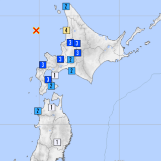
The 1940 Shakotan earthquake occurred on August 2 at 00:08:22 JST with a moment magnitude (Mw ) of 7.5 and maximum JMA seismic intensity of Shindo 4. The shock had an epicenter off the coast of Hokkaido, Japan. Damage from the shock was comparatively light, but the accomanying tsunami was destructive. The tsunami caused 10 deaths and 24 injuries on Hokkaido, and destroyed homes and boats across the Sea of Japan. The highest tsunami waves were recorded at the coast of Russia while along the coast of Hokkaido, waves were about 2 m.


