The Modified Mercalli intensity scale measures the effects of an earthquake at a given location. This is in contrast with the seismic magnitude usually reported for an earthquake.

The 1811–1812 New Madrid earthquakes were a series of intense intraplate earthquakes beginning with an initial earthquake of moment magnitude 7.2–8.2 on December 16, 1811, followed by a moment magnitude 7.4 aftershock on the same day. Two additional earthquakes of similar magnitude followed in January and February 1812. They remain the most powerful earthquakes to hit the contiguous United States east of the Rocky Mountains in recorded history. The earthquakes, as well as the seismic zone of their occurrence, were named for the Mississippi River town of New Madrid, then part of the Louisiana Territory and now within the U.S. state of Missouri.

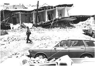
The 1983 Coalinga earthquake struck at 4:42 p.m. Monday, May 2 of that year, in Coalinga, California.
The Richter scale, also called the Richter magnitude scale, Richter's magnitude scale, and the Gutenberg–Richter scale, is a measure of the strength of earthquakes, developed by Charles Richter in collaboration with Beno Gutenberg, and presented in Richter's landmark 1935 paper, where he called it the "magnitude scale". This was later revised and renamed the local magnitude scale, denoted as ML or ML .
The 1867 Manhattan earthquake struck Riley County, Kansas, in the United States on April 24, 1867, at 20:22 UTC, or about 14:30 local time. The strongest earthquake to originate in the state, it measured 5.1 on a seismic scale that is based on an isoseismal map or the event's felt area. The earthquake's epicenter was near the town of Manhattan.
Seismic intensity scales categorize the intensity or severity of ground shaking (quaking) at a given location, such as resulting from an earthquake. They are distinguished from seismic magnitude scales, which measure the magnitude or overall strength of an earthquake, which may, or perhaps may not, cause perceptible shaking.
The 1927 Lompoc earthquake occurred on November 4 at 05:49 PST with an epicenter off the coast of Santa Barbara County Southern California. The earthquake measured 7.0 on the moment magnitude scale and had a maximum Modified Mercalli intensity of IX (Violent). It caused widespread damage in several towns of Santa Barbara County. A 2 m tsunami damaged railroad infrastructure and was recorded in Hawaii. There were no injuries or deaths from the earthquake.
A major earthquake occurred during the rule of the Qing dynasty in Shandong Province on July 25, 1668. It had an estimated magnitude of 8.5, making it the largest historical earthquake in East China, and one of the largest to occur on land. An estimated 43,000 to 50,000 people were killed, and its effects were widely felt. Its epicenter may have been located between Ju and Tancheng counties, northeast of the prefecture-level city of Linyi in southern Shandong.
The 1906 Manasi earthquake (玛纳斯地震), also known as the Manas earthquake occurred in the morning of December 23, 1906, at 02:21 UTC+8:00 local time or December 22, 18:21 UTC. It measured 8.0–8.3 on the moment magnitude scale and 8.3 on the surface-wave magnitude scale. The epicenter of this earthquake is located in Manas County, Xinjiang, China. An estimated 280–300 people died and another 1,000 more were injured by the earthquake.
The 2020 Kashgar earthquake, also known as the Jiashi earthquake occurred on 19 January 2020 at 21:27:56 China Standard Time in Xinjiang Province, China. According to the United States Geological Survey, the earthquake had a moment magnitude of 6.0 and a surface-wave magnitude of 6.4 according to the China Earthquake Network Center. It struck at a shallow depth of 5.6 km according to the USGS while the CENC has the figure at 16 km. Local emergency management agencies said the earthquake damaged more than 1,000 homes and businesses in the nearby populated towns and villages. One person is known to have died while two other children were injured.
The 1900 Venezuelan earthquake also known as the San Narciso earthquake, occurred on October 28 at between 4:30 and 4:45 am local time. This earthquake had an epicenter off Miranda State or near the Venezuelan capital Caracas, in the Cariaco Basin. It had an estimated moment magnitude of 7.6–7.7 and a surface-wave magnitude of 7.7–8.4. It had a maximum Mercalli intensity assigned VIII–X, causing landslides and liquefaction events. Many buildings were severely damaged or collapsed during the earthquake. It is thought to be the last great earthquake of the 19th century and the largest instrumentally recorded in the republic, having been felt throughout.
The 1995 Menglian earthquake or 1995 Myanmar–China earthquake occurred on 12 July at 05:46:43 local time in the Myanmar–China border region. The earthquake had an epicenter on the Myanmar side of the border, located in the mountainous region of Shan State. It registered 7.3 on the Chinese surface-wave magnitude scale (Ms ) and 6.8 on the moment magnitude scale (Mw ). With a maximum Mercalli intensity assigned at VIII, it killed 11 people and left another 136 injured. Over 100,000 homes in both countries were destroyed and 42,000 seriously damaged. Some damage to structures were also reported in Chiang Mai and Chiang Rai, Thailand. The low death toll from this earthquake was attributed to an early warning issued prior to it happening. Precursor events including foreshocks and some seismic anomalies led to an evacuation of the area before the mainshock struck. It is thought to be one of the few successfully predicted earthquakes in history.
The 1947 Satipo earthquake was the largest earthquake in the sub-Andean region of Peru. It occurred on November 1 at 09:58:57 local time with an epicenter in the Department of Junín. The earthquake had an estimated moment magnitude (Mw ) of 7.7 and focal depth of 20 km (12 mi). Damage was severe in the towns of Satipo and La Merced, and at least 233 people died.

On November 22, 2014, at 22:08 local time, an earthquake struck southeast of Hakuba, Nagano Prefecture. It had a magnitude of 6.2 according to the United States Geological Survey, with a maximum intensity assigned IX (Violent) on the Modified Mercalli intensity scale. According to the Japan Meteorological Agency, it is recorded as 6.7 and at its peak intensity at Shindo 6 Lower on the Japan Meteorological Agency seismic intensity scale. The earthquake did not result in any deaths, however 41 people sustained mild to severe injuries.
The 1909 Benavente earthquake occurred on 23 April at 17:39:36 local in the Santarém District of the Central Region, Portugal. The estimated moment magnitude 6.0–6.3 earthquake had a maximum Mercalli intensity of IX (Violent). It nearly destroyed the town of Benavente, killing 60 and injuring 75 people as a result.
The 1954 Sofades earthquake struck central Greece on 30 April 1954, at 16:02 (UTC+3). It was estimated to be 6.7–7.0 Mw and had a maximum Modified Mercalli intensity of X (Extreme). More than 25 people died, 717 were injured and about 28,000 structures were damaged or destroyed.
The 1937 Heze earthquakes struck the Mudan District in Shandong Province, China on July 31 and August 1 respectively. The moment magnitude 7.0 and 6.7 earthquakes were centered near the city of Heze. Although the total number of casualties has never been finalized, at least 3,252 people died and 12,701 were injured. The earthquakes also killed more than 6,000 livestock and destroyed 470,000 homes. Due to the outbreak of the Second Sino-Japanese War, rescue operations by the Chinese government were ineffective.
The 1858 Prome earthquake occurred on August 24 at 15:38 local time in British Burma. The earthquake occurred with a magnitude of 7.6–8.3 on the moment magnitude scale. It had an epicenter in near the city of Pyay (Prome), Bago. The shock was felt with a maximum Modified Mercalli intensity of XI (Extreme) for about one minute. Severe damage was reported in Bago, and off the coast of Rakhine, an island sunk.
The 1983 Kaoiki earthquake struck southern Hawaii Island on the morning of November 16, 1983. Measuring Mw 6.7, it was the largest to hit the island since 1975. The epicenter was located 50 km (30 mi) southeast of Hilo with an approximated depth of 12 km (7 mi). The shallow strike-slip earthquake was assigned a maximum intensity of IX (Violent) on the Modified Mercalli scale. 6 people were injured, widespread damage and landslides were reported across the island.
The 1923 Torbat-e Heydarieh earthquake occurred in Razavi Khorasan province, Iran on 25 May. The Mw 6.0 earthquake, which had a maximum Modified Mercalli intensity of VIII (Severe), completely levelled the village of Quzan. The earthquake killed an estimated 2,200 people.


