
Tattenhall is a village and former civil parish, now in the parish of Tattenhall and District, 8 miles (13 km) south-east of Chester, in the unitary authority area of Cheshire West and Chester and the ceremonial county of Cheshire, England. In the 2001 census, the population was recorded as 1,986, increasing to 2,079 by the 2011 census.

Guilden Sutton is a civil parish and village in the unitary authority of Cheshire West and Chester and the ceremonial county of Cheshire, England. The village lies approximately 3 miles (5 km) to the east of Chester and is south of the village of Mickle Trafford. The community consists of a church, a primary school, a post office, a pub, a village hall and several local businesses.

Alvanley is a small rural village and civil parish near Helsby, in the unitary authority of Cheshire West and Chester and the ceremonial county of Cheshire, England. The village is on the B5393 road and near junction 14 of the M56 motorway. According to the 2011 census the civil parish had a population of 472.
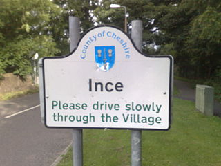
Ince is a village and civil parish in the unitary authority of Cheshire West and Chester and the ceremonial county of Cheshire, England. It is situated immediately to the east of the Stanlow Oil Refinery. It shares Ince & Elton railway station with the village of Elton, which it runs into.

Aston is a village and civil parish in the unitary authority area of Cheshire West and Chester and the ceremonial county of Cheshire, England. According to the 2001 census it had a population of 111, reducing slightly to 106 at the 2011 census. The village is just outside the Runcorn urban area. From 1974 to 2009 it was in Vale Royal district.

Backford is a village and civil parish in the unitary authority of Cheshire West and Chester and ceremonial county of Cheshire, England. It is situated between Chester and Ellesmere Port on the A41 trunk road, to the north of the Shropshire Union Canal. Backford Cross is located about 2.5 km (1.6 mi) to the north, the village of Mollington is approximately 2.5 km (1.6 mi) to the west and the hamlet of Croughton is about 3 km (1.9 mi) to the east.

Buerton is a former civil parish, now in the parish of Aldford and Saighton, in the unitary authority area of Cheshire West and Chester and the ceremonial county of Cheshire, England. According to the 2001 census it had a population of 22. Buerton was formerly a chapelry in the parish of St Oswald, in 1866 Buerton became a separate civil parish, on 1 April 2015 the parish was abolished to form "Aldford and Saighton". From 1974 to 2009 it was in Chester district.

Malpas is a market town and a civil parish in the unitary authority of Cheshire West and Chester and the ceremonial county of Cheshire, England. It lies near the borders with Shropshire and Wales, and had a population of 1,673 at the 2011 census.

Mollington is a village and civil parish in the unitary authority of Cheshire West and Chester and the ceremonial county of Cheshire, England. It is two miles north of the city of Chester, with the A41 Liverpool–Chester trunk road and Shropshire Union Canal to the east and southeast, the A540 Wirral peninsula trunk road to the south and west and the A5117 link road to the north. Nearby settlements include Backford, Blacon, Capenhurst and Saughall.
Hartford is a village and civil parish in the unitary authority of Cheshire West and Chester and the ceremonial county of Cheshire, England. It lies at the intersection of the A559 road and the West Coast Main Line and is less than 2 miles (3.2 km) south west of the town of Northwich. It forms part of the Mid Cheshire parliamentary constituency. According to the 2011 Census, the population of the parish was 5,558.

Shotwick is a small village and former civil parish, now in the parish of Puddington, on the southern end of the Wirral Peninsula in the unitary authority of Cheshire West and Chester and the ceremonial county of Cheshire, England. The village is close to the county of Flintshire on the England–Wales border. The village was located on the River Dee until it was canalised in 1736 after which the reclaimed land has since developed into the neighbouring Deeside Industrial Park.

Calveley is a village and former civil parish, now in the parish of Alpraham and Calveley, in the unitary authority area of Cheshire East and the ceremonial county of Cheshire, England. The village lies 5½ miles to the north west of Nantwich. The parish also includes parts of the settlements of Barrets Green and Wardle Bank. The total population is 280 people. The area is largely agricultural and includes a short stretch of the Shropshire Union Canal. There is an Anglican parish church, a primary school and a public house. Nearby villages include Alpraham, Bunbury, Haughton and Wardle. In 2011 the parish had a population of 280.
Stoke is a former civil parish, now in the parish of Stoke and Hurleston, in the unitary authority area of Cheshire East and the ceremonial county of Cheshire, England. The parish was predominantly rural with a total population of 201 in 2001, measured with the inclusion of Hurleston at 324 in the 2011 Census. The largest settlement was Barbridge, which lies 3½ miles to the north west of Nantwich. The parish also included the small settlements of Stoke Bank and Verona. Nearby villages include Aston juxta Mondrum, Burland, Calveley, Haughton, Rease Heath and Wardle.

Little Stanney is a suburban village and civil parish in the unitary authority of Cheshire West and Chester and the ceremonial county of Cheshire, England. It is located on the Wirral Peninsula between Chester and Ellesmere Port.

Dodleston is a village and civil parish in the unitary authority of Cheshire West and Chester and the ceremonial county of Cheshire, England. The village is situated to the south west of Chester, very close to the England–Wales border. The civil parish includes Balderton, Gorstella, Lower Kinnerton and Rough Hill. It is one of the three old Cheshire parishes which are situated on the Flintshire side of the River Dee.

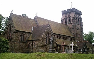
St Lawrence's Church is in the village of Stoak, Cheshire, England,. The church is recorded in the National Heritage List for England as a designated Grade II* listed building. It is an active Anglican parish church in the diocese of Chester, the archdeaconry of Chester, the deanery of Wirral South and the Ellesmere Port team ministry.

Thornton-le-Moors is a village and civil parish in the unitary authority of Cheshire West and Chester and the ceremonial county of Cheshire, England. At the census of 2001 it had a population of 260, reducing slightly to 253 at the 2011 census.

Foulk Stapleford is a former civil parish, now in the parish of Hargrave and Huxley, in the unitary authority of Cheshire West and Chester and the ceremonial county of Cheshire, England. The population of the civil parish as taken at the 2011 census was 161. Foulk-Stapleford was formerly a township in the parish of Tarvin, in 1866 Foulk Stapleford became a separate civil parish, on 1 April 2015 the parish was abolished to form Hargrave and Huxley.

Mickle Trafford is a village and former civil parish, now in the parish of Mickle Trafford and District, in the unitary authority area of Cheshire West and Chester and the ceremonial county of Cheshire, England. It includes the area known as Plemstall. The A56 road from Chester to Warrington passes through the village and the Chester-Warrington railway line passes immediately to its east.
Stoak is a civil parish in Cheshire West and Chester, England. It contains eight buildings that are recorded in the National Heritage List for England as designated listed buildings. Of these, one is listed at Grade II*, the middle grade, and the others are at Grade II. Apart from the village of Stoak, the parish is rural. The Shropshire Union Canal passes through the parish, and five of the listed buildings are bridges crossing the canal. The other listed buildings are the parish church, a sundial in the churchyard, and a farmhouse.

