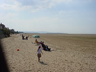
Hoylake is a seaside town in the Metropolitan Borough of Wirral, Merseyside, England. It is at the north west of the Wirral Peninsula, near West Kirby and where the River Dee meets the Irish Sea. Historically part of Cheshire, the Domesday Book of 1086 recorded it within the Hundred of Wilaveston.
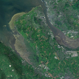
The Wirral Peninsula, known locally as the Wirral, is a peninsula in North West England. The roughly rectangular peninsula is about 15 miles (24 km) long and 7 miles (11 km) wide, and is bounded by the Dee Estuary to the west, the Mersey Estuary to the east, and Liverpool Bay to the north.

Caldy is a small, affluent village on the Wirral Peninsula, Merseyside, England, south-east of West Kirby. It is part of the West Kirby & Thurstaston Ward of the Metropolitan Borough of Wirral, and is in the parliamentary constituency of Wirral West. At the time of the 2001 Census, Caldy had 1,290 inhabitants, of a total ward population of 12,869.

Backford is a village and civil parish in the unitary authority of Cheshire West and Chester and ceremonial county of Cheshire, England. It is situated between Chester and Ellesmere Port on the A41 trunk road, to the north of the Shropshire Union Canal. Backford Cross is located about 2.5 km (1.6 mi) to the north, the village of Mollington is approximately 2.5 km (1.6 mi) to the west and the hamlet of Croughton is about 3 km (1.9 mi) to the east.

Mollington is a village and civil parish in the unitary authority of Cheshire West and Chester and the ceremonial county of Cheshire, England. It is two miles north of the city of Chester, with the A41 Liverpool–Chester trunk road and Shropshire Union Canal to the east and southeast, the A540 Wirral peninsula trunk road to the south and west and the A5117 link road to the north. Nearby settlements include Backford, Blacon, Capenhurst and Saughall.
The Urenco Group is a British-German-Dutch nuclear fuel consortium operating several uranium enrichment plants in Germany, the Netherlands, United States, and United Kingdom. It supplies nuclear power stations in about 15 countries, and states that it had a 29% share of the global market for enrichment services in 2011. Urenco uses centrifuge enrichment technology.

Thurstaston is a village and former civil parish, in the Wirral district, in Merseyside, England, on the Wirral Peninsula. It is part of the West Kirby and Thurstaston Ward and the parliamentary constituency of Wirral West. The village lies on the A540 road between Heswall and Caldy, although it extends some distance down Station Road to the Wirral Way and the River Dee estuary.

Little Sutton is a village on the Wirral Peninsula, in the unitary authority area of Cheshire West and Chester and the ceremonial county of Cheshire, England. Located between Childer Thornton and Great Sutton, it is a suburb of the town of Ellesmere Port. Little Sutton is mostly residential and sits either side of the A41 road, linking Birkenhead and Chester.

Great Sutton is a village on the Wirral Peninsula, in the unitary authority area of Cheshire West and Chester and the ceremonial county of Cheshire, England. It is a suburb of Ellesmere Port and, as with Little Sutton to the north, was once a separate village that was incorporated into the town as it expanded outwards.

Puddington is a village and civil parish on the Wirral Peninsula, in the unitary authority of Cheshire West and Chester and the ceremonial county of Cheshire, England. It is located to the south east of the town of Neston and close to the border with Wales.

Woodbank is a village and former civil parish, now in the parish of Puddington, in the unitary authority of Cheshire West and Chester and the ceremonial county of Cheshire in northwest England. It is located on the Wirral Peninsula, about 6 miles northwest of the city of Chester and near the larger village of Saughall. In 2001 the parish had a population of 62.
The British Telecom microwave network was a network of point-to-point microwave radio links in the United Kingdom, operated at first by the General Post Office, and subsequently by its successor BT plc. From the late 1950s to the 1980s it provided a large part of BT's trunk communications capacity, and carried telephone, television and radar signals and digital data, both civil and military. Its use of line-of-sight microwave transmission was particularly important during the Cold War for its resilience against nuclear attack. It was rendered obsolete, at least for normal civilian purposes, by the installation of a national optical fibre communication network with considerably higher reliability and vastly greater capacity.
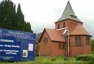
Saughall is a village in the civil parish of Saughall and Shotwick Park, in the unitary authority area of Cheshire West and Chester and the ceremonial county of Cheshire, England. Located between Shotwick and Blacon, it is approximately 4.8 km (3.0 mi) north west of Chester and 1.8 km (1.1 mi) from Sealand across the Welsh border.

Ledsham is a village and civil parish in the unitary authority of Cheshire West and Chester and the ceremonial county of Cheshire, England. The civil parish includes parts of the hamlets of Badger's Rake and Two Mills. It is located on the Wirral Peninsula, approximately 10 km (6.2 mi) to the north of the city of Chester and 6 km (3.7 mi) to the west of Ellesmere Port.

Cheshire West and Chester is a unitary authority area with borough status in Cheshire, England. It was established on 1 April 2009 as part of the 2009 local government changes, by virtue of an order under the Local Government and Public Involvement in Health Act 2007. It superseded the boroughs of Ellesmere Port and Neston, Vale Royal and the City of Chester. The remainder of the ceremonial county of Cheshire is composed of Cheshire East, Halton and Warrington. Cheshire West and Chester has three key urban areas: Chester, Ellesmere Port and Northwich/Winsford.

St Oswald's Church is in the village of Backford, to the northwest of Chester, Cheshire, England, close to the A41 road and adjoining Backford Hall. It is recorded in the National Heritage List for England as a designated Grade II* listed building. The church dates from the 14th century with later additions and restorations. It contains one of the few surviving aumbries in Cheshire and a number of memorial boards painted by the Randle Holme family. It is an active Anglican parish church in the diocese of Chester, the archdeaconry of Chester and the deanery of Wirral South. Its benefice is combined with that of Holy Trinity Church, Capenhurst. From March 2018 this benefice shares a vicar with All Saints, Saughall.

Little Stanney is a suburban village and civil parish in the unitary authority of Cheshire West and Chester and the ceremonial county of Cheshire, England. It is located on the Wirral Peninsula between Chester and Ellesmere Port.

Holy Trinity Church, Capenhurst is in the village of Capenhurst, Cheshire, England. The church is recorded in the National Heritage List for England as a designated Grade II listed building. It is an active Anglican parish church in the diocese of Chester, the archdeaconry of Chester and the deanery of Wirral South. Its benefice is combined with that of St Oswald, Backford.

Lea-by-Backford is a hamlet and civil parish in the unitary authority of Cheshire West and Chester and the ceremonial county of Cheshire, England. It is situated between Chester and Ellesmere Port, west of the A41 trunk road and to the north of the Shropshire Union Canal. Backford is approximately 1.2 mi (2 km) to the east and Mollington is approximately 1.2 mi (2 km) to the south.

Ince Power Station refers to two demolished power stations near Ellesmere Port in Cheshire, North West England.

