
Kelsall is a village and civil parish in the unitary authority of Cheshire West and Chester and the ceremonial county of Cheshire, England. It is located around 8 miles (13 km) east of Chester, 8 miles (13 km) west of Northwich, and 4 miles (6 km) north west of Tarporley. The village is situated on Kelsall Hill, a part of the Mid-Cheshire Ridge, the broken line of sandstone hills that divide the west Cheshire Plain from its eastern counterpart. The ridge includes other hills including Peckforton, Beeston, Frodsham, and Helsby.
Chester was a non-metropolitan local government district of Cheshire, England from 1974 to 2009. It had the status of a city and a borough, and the local authority was called Chester City Council.

A civil parish is a country subdivision, forming the lowest unit of local government in England. There are 333 civil parishes in the ceremonial county of Cheshire, most of the county being parished. Cheshire East unitary authority is entirely parished. At the 2001 census, there were 565,259 people living in 332 parishes, accounting for 57.5 per cent of the county's population.

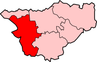
Eddisbury was a constituency in Cheshire last represented in the House of Commons of the UK Parliament since 2019 by Edward Timpson, a Conservative who left office at the dissolution of parliament in advance of the 2024 United Kingdom general election, at which this former constituency was replaced.
Tarvin is a village in the unitary authority of Cheshire West and Chester and the ceremonial county of Cheshire, England. It had a population of 2,693 people at the 2001 UK census, rising to 2,728 at the 2011 census, and the ward covers about 17 square miles (44 km2).

Ashton Hayes is a village and former civil parish, now in the parish of Ashton Hayes and Horton-cum-Peel, in the unitary authority of Cheshire West and Chester and ceremonial county of Cheshire, England. It is located about 8 miles east of Chester on the B5393 road. The nearest villages are Mouldsworth to the north east and Kelsall to the south east. According to the 2011 Census it had a population of 936. The main village in the parish – formerly known as Ashton – was renamed Ashton Hayes following a referendum, to avoid confusion with other places of the same name.
Barrow is a civil parish, in the unitary authority of Cheshire West and Chester and the ceremonial county of Cheshire, England. The civil parish contains the village of Great Barrow and the hamlets of Little Barrow, Broomhill and Stamford Bridge. Great Barrow is situated about 4.5 miles east-north-east of Chester, 6 miles north-west of Tarporley and 6 miles south of Frodsham.

Bruen Stapleford is a former civil parish, now in the parish of Tarvin in the unitary authority area of Cheshire West and Chester and the ceremonial county of Cheshire, England. According to the 2001 census it had a population of 66, rising to 186 at the 2011 Census.

Tushingham cum Grindley is a former civil parish, now in the parish of Tushingham-cum-Grindley, Macefen and Bradley, in the unitary authority of Cheshire West and Chester and the ceremonial county of Cheshire, England. The parish contained the village of Tushingham and the hamlet of Bell o' th' Hill. According to the 2001 UK census, the total population of the civil parish was 166, rising to 187 at the 2011 Census.

Malpas is a market town and a civil parish in the unitary authority of Cheshire West and Chester and the ceremonial county of Cheshire, England. It lies near the borders with Shropshire and Wales, and had a population of 1,673 at the 2011 census.

Tarvin was, from 1894 to 1974, a rural district in the administrative county of Cheshire, England. The district was named after the village of Tarvin, and saw considerable boundary changes throughout its life.

Puddington is a village and civil parish on the Wirral Peninsula, in the unitary authority of Cheshire West and Chester and the ceremonial county of Cheshire, England. It is located to the south east of the town of Neston and close to the border with Wales.

Willington is a village and civil parish 9 miles (14 km) from Chester in Cheshire, England. At the 2011 census, the population was 277.

Burton is a small village and former civil parish, now in the parish of Duddon and Burton, in the unitary authority of Cheshire West and Chester and the ceremonial county of Cheshire, England. In the 2001 census, the parish had a population of 50.

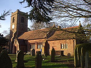
St Andrew's Church is in the village of Tarvin, Cheshire, England. The church is recorded in the National Heritage List for England as a designated Grade I listed building. It is an active Anglican parish church in the diocese of Chester, the archdeaconry of Chester and the deanery of Chester. Its benefice is united with that of St Peter, Duddon.

Foulk Stapleford is a former civil parish, now in the parish of Hargrave and Huxley, in the unitary authority of Cheshire West and Chester and the ceremonial county of Cheshire, England. The population of the civil parish as taken at the 2011 census was 161. Foulk-Stapleford was formerly a township in the parish of Tarvin, in 1866 Foulk Stapleford became a separate civil parish, on 1 April 2015 the parish was abolished to form Hargrave and Huxley.
Hockenhull is a former civil parish, now in the parish of Tarvin, in the borough of Cheshire West and Chester and ceremonial county of Cheshire in England. In 2001 it had a population of 19. Hockenhull was formerly a township, in 1866 Hockenhull became a civil parish, on 1 April 2015 the parish was abolished and merged with Tarvin.

Littleton is a village and civil parish in the Borough of Cheshire West and Chester and ceremonial county of Cheshire, England. It is near the A51 road, approximately 3 miles (4.8 km) east of Chester.
Great Boughton is a former civil parish in Cheshire West and Chester, England. It contained seven buildings that are recorded in the National Heritage List for England as designated listed buildings, all of which are at Grade II. This grade is the lowest of the three gradings given to listed buildings and is applied to "buildings of national importance and special interest". The parish was mainly residential, forming a suburb to the east of Chester, and two of the listed buildings are houses dating from the 18th century. Running through the parish is the Shropshire Union Canal ; associated with this are three listed buildings, two locks and a cottage. The other listed structures are two boundary stones.
Duddon and Burton is a civil parish in the unitary authority of Cheshire West and Chester and the ceremonial county of Cheshire, England. The parish is formed of the villages of Duddon and Burton.

