
West Midlands is a metropolitan and ceremonial county in the larger West Midlands region of England. A landlocked county, it is bordered by Staffordshire to the north and west, Worcestershire to the south, and is surrounded by Warwickshire to the east. The largest settlement is the city of Birmingham.

The M6 motorway is the longest motorway in the United Kingdom. It is located entirely within England, running for just over 230 miles (370 km) from the Midlands to the border with Scotland. It begins at Junction 19 of the M1 and the western end of the A14 at the Catthorpe Interchange, near Rugby before heading north-west. It passes Coventry, Birmingham, Wolverhampton, Stoke-on-Trent, Preston, Lancaster and Carlisle before terminating at Junction 45 near Gretna. Here, just short of the Scottish border it becomes the A74(M) which continues to Glasgow as the M74. Its busiest sections are between junctions 4 and 10a in the West Midlands, and junctions 16 to 19 in Cheshire; these sections have now been converted to smart motorways.

The West Midlands Metro is a light-rail/tram system in the county of West Midlands, England. The network has 33 stops with a total of 14 miles (23 km) of track; it currently consists of a single route, Line 1, which operates between the cities of Birmingham and Wolverhampton via the towns of Bilston, West Bromwich and Wednesbury, on a mixture of former railway lines and urban on-street running. The system is owned by the public body Transport for West Midlands, and operated by Midland Metro Limited, a company wholly owned by the West Midlands Combined Authority.

The M5 is a motorway in England linking the Midlands with the South West. It runs from junction 8 of the M6 at West Bromwich near Birmingham to Exeter in Devon. Heading south-west, the M5 runs east of West Bromwich and west of Birmingham through Sandwell Valley. It continues past Bromsgrove, Droitwich Spa, Worcester, Tewkesbury, Cheltenham, Gloucester, Bristol, Portishead, Clevedon, Weston-super-Mare, Bridgwater, Taunton, Tiverton, Cullompton terminating at junction 31 for Exeter. Congestion on the section south of the M4 is common during the summer holidays, on Friday afternoons and bank holidays.

The West Midlands conurbation is the large conurbation in the West Midlands region of England. The area consists of two cities and numerous towns: to the east, the city of Birmingham, along with adjacent towns of Solihull and Sutton Coldfield; and to the west, the city of Wolverhampton and the area called the Black Country, containing the towns of Dudley, Walsall, West Bromwich, Oldbury, Willenhall, Bilston, Darlaston, Tipton, Smethwick, Wednesbury, Rowley Regis, Stourbridge and Halesowen.
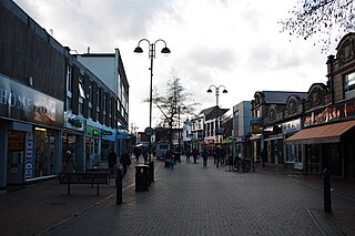
Bilston is a market town in the City of Wolverhampton in the West Midlands, England. It is close to the borders of Sandwell and Walsall. The nearest towns are Darlaston, Wednesbury, and Willenhall. Historically in Staffordshire, three wards of Wolverhampton City Council now cover the town: Bilston East and Bilston North, which almost entirely comprise parts of the historic Borough of Bilston, and Ettingshall, which comprises a part of Bilston and parts of Wolverhampton.

The A31 is a major trunk road in southern England that runs from Guildford in Surrey to Bere Regis in Dorset. Its most well known section is the Hog's Back, a hilly ridge forming part of the North Downs, in the Surrey stretch between Guildford and Farnham.
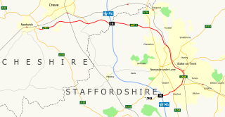
The A500 is a major primary A road in Staffordshire and Cheshire, England. It is dual carriageway for most of its length and connects Nantwich, junctions 16 and 15 of the M6 motorway with the city of Stoke-on-Trent. It is 19 miles (31 km) long.

Coseley is a village in the Dudley Metropolitan Borough, in the West Midlands County, England. It is situated three miles north of Dudley itself, on the border with Wolverhampton and Sandwell. It falls within the Tipton and Wednesbury parliamentary constituency.

The A299, better known as the Thanet Way, is a major road of 22 miles (35 km) in the county of Kent, England, and runs from Brenley Corner near Faversham to Ramsgate via Whitstable and Herne Bay.
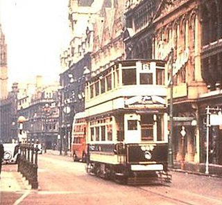
Birmingham Corporation Tramways operated a network of tramways in Birmingham from 1904 until 1953. It was the largest narrow-gauge tramway network in the UK, and was built to a gauge of 3 ft 6 in. It was the fourth largest tramway network in the UK behind London, Glasgow and Manchester.
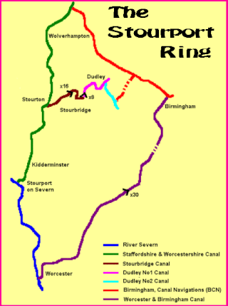
The Stourport Ring is a connected series of canals forming a circuit, or canal ring, around Worcestershire, The Black Country and Birmingham in The Midlands, England. The ring is formed from the River Severn, the Staffordshire and Worcestershire Canal, the Stourbridge Canal, the Dudley Canals, the Birmingham Canal Navigations and the Worcester and Birmingham Canal.
The A491 is an A road in Zone 4 of the Great Britain numbering scheme.
The BCN Main Line, or Birmingham Canal Navigations Main Line is the evolving route of the Birmingham Canal between Birmingham and Wolverhampton in England.

Wolverhampton is a city and metropolitan borough in the West Midlands, England. Located 12 miles (19 km) northwest of Birmingham, the population in 2021 was 263,700.

Wednesbury Old Canal is part of the Birmingham Canal Navigations (BCN) in the English West Midlands. It opened in 1769, and although parts of it were abandoned in 1955 and 1960, the section between Pudding Green Junction and Ryder's Green Junction is navigable, as it provides a link to the Walsall Canal. A short stub beyond Ryder's Green Junction is connected to the network but difficult to navigate.

The Ridgacre Branch is a canal branch of the Wednesbury Old Canal, part of the Birmingham Canal Navigations, in the West Midlands, England. It opened in 1828, to serve collieries and iron works, and was disused by the 1960s. Except for its branches and a small section at the eastern end, which have been filled in, most of it is still in water, but it is not navigable as a low-level bridge carrying the Black Country New Road spans the entrance.
Stephen (Steve) Field RBSA is an English sculptor, muralist and mosaicist, active mainly in the West Midlands, particularly the Black Country, where a number of his works are on public display. He has been resident artist and public art adviser to Dudley Metropolitan Borough Council, since 1988, and is a member of the Royal Birmingham Society of Artists, the Contemporary Glass Society and the British Association of Modern Mosaic. He coordinated Dudley's Millennium Sculpture Trail.
