Warrenton, Georgia

Last updated

Warrenton, Georgia
Warren County Courthouse, Warrenton, GA.jpg
Warren County Courthouse
Warren County Georgia Incorporated and Unincorporated areas Warrenton Highlighted.svg
Location in Warren County and the state of Georgia
Coordinates: 33°24′27″N82°39′46″W / 33.40750°N 82.66278°W / 33.40750; -82.66278
Country United States
State Georgia
County Warren
Area
[1]
  Total1.92 sq mi (4.98 km2)
  Land1.91 sq mi (4.94 km2)
  Water0.02 sq mi (0.04 km2)
Elevation
518 ft (158 m)
Population
 (2020)
  Total1,744
  Density914.53/sq mi (353.09/km2)
Time zone UTC-5 (Eastern (EST))
  Summer (DST) UTC-4 (EDT)
ZIP code
30828
Area code 706
FIPS code 13-80592 [2]
GNIS feature ID0333368 [3]
Website www.warrentonga.gov

Warrenton is a city and the county seat of Warren County, Georgia, United States. [4] The population was 1,744 in 2020.

Contents

History

Warrenton was founded in 1797 as seat of Warren County (est. 1793). It was incorporated as a town in 1810 and as a city in 1908. [5] The community was named for American Revolutionary War general Joseph Warren. [6]

On May 2, 1919 a crowd of three hundred white farmers shot to death and burned the corpse of a black farmer, Benny Richards, who was accused of murdering his own ex-wife. [7]

Geography

Warrenton is located at 33°24′27″N82°39′46″W / 33.40750°N 82.66278°W / 33.40750; -82.66278 (33.407596, -82.662914). [8] According to the United States Census Bureau, the city has a total area of 1.9 square miles (4.9 km2), of which, 1.9 square miles (4.9 km2) of it is land and 0.52% is water.

Climate

Climate data for Warrenton, Georgia, 1991–2020 normals, extremes 19142017
MonthJanFebMarAprMayJunJulAugSepOctNovDecYear
Record high °F (°C)86
(30)
83
(28)
90
(32)
95
(35)
100
(38)
110
(43)
109
(43)
107
(42)
108
(42)
99
(37)
90
(32)
80
(27)
110
(43)
Mean maximum °F (°C)71.1
(21.7)
75.3
(24.1)
81.1
(27.3)
86.3
(30.2)
90.6
(32.6)
95.8
(35.4)
97.8
(36.6)
96.9
(36.1)
92.5
(33.6)
85.7
(29.8)
79.7
(26.5)
73.2
(22.9)
99.2
(37.3)
Mean daily maximum °F (°C)56.2
(13.4)
59.4
(15.2)
67.1
(19.5)
75.0
(23.9)
82.2
(27.9)
88.0
(31.1)
91.2
(32.9)
89.5
(31.9)
84.4
(29.1)
75.3
(24.1)
65.9
(18.8)
58.1
(14.5)
74.4
(23.5)
Daily mean °F (°C)44.7
(7.1)
47.4
(8.6)
54.1
(12.3)
61.6
(16.4)
69.6
(20.9)
76.6
(24.8)
80.2
(26.8)
78.8
(26.0)
73.3
(22.9)
63.0
(17.2)
53.0
(11.7)
46.7
(8.2)
62.4
(16.9)
Mean daily minimum °F (°C)33.1
(0.6)
35.4
(1.9)
41.1
(5.1)
48.3
(9.1)
57.1
(13.9)
65.3
(18.5)
69.1
(20.6)
68.2
(20.1)
62.2
(16.8)
50.7
(10.4)
40.1
(4.5)
35.3
(1.8)
50.5
(10.3)
Mean minimum °F (°C)16.4
(−8.7)
20.9
(−6.2)
25.6
(−3.6)
33.1
(0.6)
43.8
(6.6)
56.1
(13.4)
62.2
(16.8)
60.5
(15.8)
48.5
(9.2)
35.1
(1.7)
27.8
(−2.3)
19.7
(−6.8)
14.0
(−10.0)
Record low °F (°C)−3
(−19)
7
(−14)
11
(−12)
26
(−3)
37
(3)
40
(4)
53
(12)
52
(11)
36
(2)
26
(−3)
9
(−13)
5
(−15)
−3
(−19)
Average precipitation inches (mm)4.47
(114)
4.21
(107)
4.94
(125)
3.04
(77)
3.07
(78)
4.04
(103)
3.94
(100)
4.59
(117)
3.97
(101)
3.42
(87)
3.38
(86)
3.93
(100)
47
(1,195)
Average precipitation days (≥ 0.01 in)7.56.96.85.76.06.87.17.35.04.85.46.876.1
Source 1: NOAA [9]
Source 2: National Weather Service (mean maxima/minima, precip/precip days 19812010) [10]

Demographics

Historical population
CensusPop.Note
1880 1,022
1890 974−4.7%
1900 1,11314.3%
1910 1,36822.9%
1920 1,4072.9%
1930 1,289−8.4%
1940 1,284−0.4%
1950 1,44212.3%
1960 1,77022.7%
1970 2,07317.1%
1980 2,1724.8%
1990 2,056−5.3%
2000 2,013−2.1%
2010 1,937−3.8%
2020 1,744−10.0%
U.S. Decennial Census [11]
Warrenton racial composition as of 2020 [12]
RaceNum.Perc.
White (non-Hispanic)40923.45%
Black or African American (non-Hispanic)1,27673.17%
Native American 20.11%
Asian 100.57%
Other/Mixed 352.01%
Hispanic or Latino 120.69%

As of the 2020 United States census, there were 1,744 people, 840 households, and 528 families residing in the city.

Education

Warren County School District

The Warren County School District holds pre-school to grade twelve, and consists of one elementary school, a middle school, and a high school. [13] (The district has only 2 physical buildings, one for Pre-K and K, the other for 1-12.)The district has 70 full-time teachers and over 894 students. [14]

See also

Related Research Articles

<span class="mw-page-title-main">Warren County, Georgia</span> County in Georgia, United States

Warren County is a county located in the U.S. state of Georgia. As of the 2020 United States census, the population was 5,215, a decrease from 2010. The county seat is Warrenton. The county was created on December 19, 1793, and is named after General Joseph Warren, who was killed in the Battle of Bunker Hill.

<span class="mw-page-title-main">Nahunta, Georgia</span> City in Georgia, United States

Nahunta is a city and the county seat in Brantley County, Georgia, United States. It is part of the Brunswick, Georgia metropolitan statistical area. The population was 1,013 at the 2020 census. The city is an important crossroad which is intersected by U.S. Route 82 and U.S. Route 301 in its downtown area.

<span class="mw-page-title-main">Metter, Georgia</span> City in Georgia, United States

Metter is a city and the county seat of Candler County, Georgia, United States. The population was 4,130 at the 2010 census. In 2020, its population was 4,004.

<span class="mw-page-title-main">Douglas, Georgia</span> City in Georgia, United States

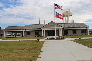
Douglas is a city in Coffee County, Georgia, United States. As of the 2020 census, the city had a population of 11,722. Douglas is the county seat of Coffee County and the core city of the Douglas micropolitan statistical area, which had a population of 50,731 as of the 2010 census.

<span class="mw-page-title-main">Springfield, Georgia</span> City in Georgia, United States

Springfield is a city in Effingham County, Georgia, United States. The population was 2,703 as of the 2020 census. The city is the county seat of Effingham County. Springfield is part of the Savannah Metropolitan Statistical Area.

<span class="mw-page-title-main">Gibson, Georgia</span> City in Georgia, United States

Gibson is a city and the county seat of Glascock County, Georgia, United States, and is home to the Glascock County Courthouse, a National Register of Historic Places listed site. The population was 663 at the 2010 census, and 630 in 2020.

<span class="mw-page-title-main">Greensboro, Georgia</span> City in Georgia, United States

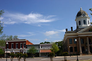
Greensboro is a city in and the county seat of Greene County, Georgia, United States. Its population was 3,648 as of the 2020 census. The city is located approximately halfway between Atlanta and Augusta on Interstate 20.

<span class="mw-page-title-main">Sparta, Georgia</span> City in Georgia, United States

Sparta is a city in and the county seat of Hancock County, Georgia, United States. It used to be part of the Milledgeville micropolitan statistical area until 2023. The city's population was 1,400 at the 2010 census.

<span class="mw-page-title-main">Hartwell, Georgia</span> City in Georgia, United States

Hartwell is a city in Hart County, Georgia, United States. The population was 4,469 at the 2010 census. The city is the county seat of Hart County.

<span class="mw-page-title-main">Monticello, Georgia</span> City in Georgia, United States

Monticello is the largest city in and the county seat of Jasper County, Georgia, United States. The city includes historic buildings such as the Jasper County Courthouse, Monticello High School and the Monticello Historic District. The population was 2,541 in 2020. It is 56 miles (90 km) southeast of Atlanta.

<span class="mw-page-title-main">Stapleton, Georgia</span> City in Georgia, United States

Stapleton is a city in Jefferson County, Georgia, United States. The population was 402 in 2020.

<span class="mw-page-title-main">Mount Vernon, Georgia</span> City in Georgia, United States

Mount Vernon is a city in, and the county seat of, Montgomery County, Georgia, United States. The population was 1,900 at the 2020 census, down from 2,451 in 2010. It is home to Brewton–Parker College.

<span class="mw-page-title-main">Lexington, Georgia</span> City in Georgia, United States

The city of Lexington is the county seat of Oglethorpe County, Georgia, United States. The population was 239 at the 2000 census.

<span class="mw-page-title-main">Concord, Georgia</span> City in Georgia, United States

Concord is a city in Pike County, Georgia, United States. The population was 378 in 2020.

<span class="mw-page-title-main">Molena, Georgia</span> City in Georgia, United States

Molena is a city in Pike County, Georgia, United States. The population was 392 in 2020.

<span class="mw-page-title-main">Zebulon, Georgia</span> City in Georgia, United States

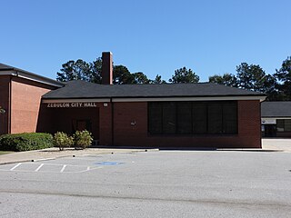
Zebulon is a city in Pike County, Georgia, United States. The population was 1,225 in 2020. The city is the county seat of Pike County. The city and county were named after explorer Zebulon Pike.

<span class="mw-page-title-main">Varnell, Georgia</span> City in Georgia, United States

Varnell is a city in Whitfield County, Georgia, United States. It is part of the Dalton, Georgia Metropolitan Statistical Area. The population was 2,179 at the 2020 census.

<span class="mw-page-title-main">Warrenton, Missouri</span> City in Missouri, United States

Warrenton is a city and county seat of Warren County, Missouri, United States. The population was 7,880 according to the 2010 Census. Warrenton is an exurb of St. Louis, and is located in the St. Louis Metropolitan Statistical Area. Warrenton's slogan is "A City for All Seasons."

<span class="mw-page-title-main">Waynesboro, Georgia</span> City in Georgia, United States

Waynesboro is a city and the county seat of Burke County, Georgia, United States. The population was 5,472 at the 2024 census. It is part of the Augusta, Georgia metropolitan area.

Appling is an unincorporated community and census-designated place (CDP) in and the county seat of Columbia County, Georgia, United States. As of the 2020 census, its population is 658. It is part of the Augusta metropolitan area.

References

  1. "2020 U.S. Gazetteer Files". United States Census Bureau. Retrieved December 18, 2021.
  2. "U.S. Census website". United States Census Bureau . Retrieved January 31, 2008.
  3. "US Board on Geographic Names". United States Geological Survey. October 25, 2007. Retrieved January 31, 2008.
  4. "Find a County". National Association of Counties. Retrieved June 7, 2011.
  5. Hellmann, Paul T. (May 13, 2013). Historical Gazetteer of the United States. Routledge. p. 252. ISBN   978-1135948597 . Retrieved November 30, 2013.
  6. Krakow, Kenneth K. (1975). Georgia Place-Names: Their History and Origins (PDF). Macon, GA: Winship Press. p. 247. ISBN   0-915430-00-2.
  7. Burning at Stake in the United States: A Record of the Public Burning by Mobs of Five Men, During the First Five Months of 1919. Black Classic Press. 1986. p. 13. ISBN   978-0-933121-13-3.
  8. "US Gazetteer files: 2010, 2000, and 1990". United States Census Bureau. February 12, 2011. Retrieved April 23, 2011.
  9. "U.S. Climate Normals Quick Access – Station: Warrenton, GA". National Oceanic and Atmospheric Administration. Retrieved May 11, 2023.
  10. "NOAA Online Weather Data – NWS Atlanta". National Weather Service. Retrieved May 11, 2023.
  11. "Census of Population and Housing". Census.gov. Retrieved June 4, 2015.
  12. "Explore Census Data". data.census.gov. Retrieved December 15, 2021.
  13. Georgia Board of Education, Retrieved June 29, 2010.
  14. School Stats, Retrieved June 29, 2010.