
Worth County is a county located in the south-central portion of the U.S. state of Georgia. As of the 2020 census, the population was 20,784. The county seat is Sylvester. Worth County is included in the Albany, GA metropolitan statistical area.

Franklin County is a county located in the northeastern part of the U.S. state of Georgia. As of the 2020 census, the population was 23,424. The county seat is Carnesville. On February 25, 1784, Franklin and Washington became Georgia's eighth and ninth counties, with Franklin named in honor of patriot Benjamin Franklin.

Dooly County is a county located in the central portion of the U.S. state of Georgia. As of the 2020 census, the population was 11,208. The county seat is Vienna. The county was created by an act of the Georgia General Assembly on May 15, 1821, and named for Colonel John Dooly, a Georgia American Revolutionary War fighter. It was one of the original landlot counties created from land ceded from the Creek Nation.

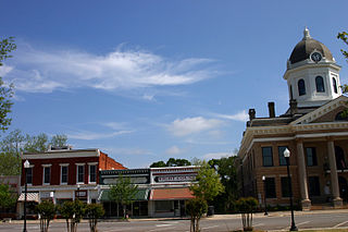
Colquitt County is a county in the U.S. state of Georgia. As of the 2020 census, the population was 45,898. The county seat is Moultrie. The county was created on February 25, 1856, and is named for Walter Terry Colquitt, a U.S. senator. Colquitt County comprises the Moultrie, GA micropolitan statistical area.
Bleckley County is a county located in the central portion of the U.S. state of Georgia. As of the 2020 census, the population was 12,583. The county seat is Cochran.

Statham is a city in Barrow County, Georgia, United States. The population was 2,408 at the 2010 census, and 2,813 in 2020.

Jackson is a city in and the county seat of Butts County, Georgia, United States. The population was 5,045 in 2010, up from 3,934 at the 2000 census. In 2020, its population was 5,557. The community was named after governor James Jackson.

Folkston is a city in and the county seat of Charlton County, Georgia, United States. The population was 4,464 in 2020.

Greensboro is a city in and the county seat of Greene County, Georgia, United States. Its population was 3,648 as of the 2020 census. The city is located approximately halfway between Atlanta and Augusta on Interstate 20.

Grayson is a city in Gwinnett County, Georgia, United States. The 2020 estimated population of Grayson, GA is 4740 people. The population was 2,666 at the 2010 census, up from 765 in 2000.

Norcross is a city located in Gwinnett County, Georgia, United States. According to the 2010 census, the population was 9,116, while in 2020, the population increased to 17,209. Norcross is part of the Atlanta-Sandy Springs-Marietta metropolitan statistical area.
Monticello is the largest city in and the county seat of Jasper County, Georgia, United States. The city includes historic buildings such as the Jasper County Courthouse, Monticello High School and the Monticello Historic District. The population was 2,541 in 2020. It is 56 miles (90 km) southeast of Atlanta.
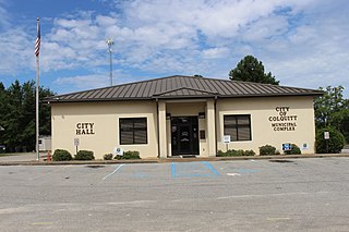
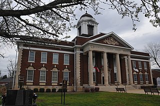
Colquitt is a city and the county seat of Miller County, in the southwestern portion of the U.S. state of Georgia. The population was 2,001 at the 2020 census. Colquitt has been the county seat of Miller County since Miller County was incorporated by the Georgia Legislature in 1856. The city formally incorporated on December 19, 1860, and is Miller County's only incorporated municipality. Colquitt is named for U.S. Congressman and Senator Walter Terry Colquitt.

Camilla is a city in Mitchell County, Georgia, United States, and is its county seat. As of the 2020 census, the city had a population of 5,187, down from 5,360 in 2010.

The city of Blackshear is the county seat of Pierce County, Georgia, United States. As of the 2020 census, the city had a population of 3,506.

Lyons is a city in Toombs County, Georgia, United States. The population was 4,239 in 2020. The city is the county seat of Toombs County.

The city of Ashburn is the county seat of Turner County, Georgia, United States. As of 2020, its population was 4,291. Ashburn's government is classified as a council/manager form of municipal government.

Monroe is a city and the county seat of Walton County, Georgia, United States. It is located both one hour east of Atlanta via US 78 and GA 138 to I-20 and east of Hartsfield–Jackson International Airport and is one of the exurban cities in the Atlanta metropolitan area. The population was 14,928 at the 2020 U.S. census.

Jesup is a city in Wayne County, Georgia, United States. The population was 9,809 at the 2020 census. The city is the county seat of Wayne County.

Irwinton is a city in Wilkinson County, Georgia, United States. The population was 531 in 2020. The city is the county seat of Wilkinson County.


