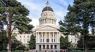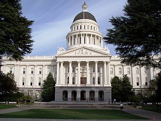
Sacramento is the capital city of the U.S. state of California and the seat of Sacramento County. Located at the confluence of the Sacramento River and the American River in Northern California's Sacramento Valley, Sacramento's estimated 2018 population of 501,334 makes it the sixth-largest city in California and the ninth largest capital in the United States. Sacramento is the seat of the California Legislature and the Governor of California, making it the state's political center and a hub for lobbying and think tanks. Sacramento is also the cultural and economic core of the Sacramento metropolitan area, which had a 2010 population of 2,414,783, making it the fifth largest in California.

Sacramento County is a county in the U.S. state of California. As of the 2010 census, the population was 1,418,788. Its county seat is Sacramento, which has been the state capital of California since 1854.

El Dorado County, officially the County of El Dorado, is a county in the U.S. state of California. As of the 2010 census, the population was 181,058. The county seat is Placerville.

The Central Valley is a flat valley that dominates the interior of California. It is 40 to 60 miles wide and stretches approximately 450 miles (720 km) from north-northwest to south-southeast, inland from and parallel to the Pacific Ocean coast. It covers approximately 18,000 square miles (47,000 km2), about 11% of California's total land area. The valley is bounded by the Sierra Nevada to the east and the Coast Ranges to the west.

Gridley is a neighborhood community with agricultural roots and an historic downtown. It's located in Butte County, California, United States, 29 miles south of Chico, California and 56 miles north of Sacramento, California. The 2019 State of California population estimate was 7,224. California State Route 99 runs through Gridley and Interstate 5 and California State Route 70 are both nearby.

Northern California is the northern portion of the U.S. state of California. Spanning the state's northernmost 48 counties, its main population centers include the San Francisco Bay Area, the Greater Sacramento area, and the Metropolitan Fresno area. Northern California also contains redwood forests, along with the Sierra Nevada, including Yosemite Valley and part of Lake Tahoe, Mount Shasta, and most of the Central Valley, one of the world's most productive agricultural regions.

Anderson Marsh State Historic Park is a California State Historic Park and nature reserve preserving a tule marsh, archaeological sites of the Pomo people, and historic ranch structures. It is located in Lake County, California, USA. Anderson Marsh is located at the head of Cache Creek on the southeast corner of Clear Lake, the largest natural lake completely within the borders of California. The park is between the cities of Lower Lake and Clearlake on State Route 53, north of Calistoga in the wine country. The park is open year-round.

Bidwell–Sacramento River State Park is a state park of California, United States, preserving riparian habitat on the Sacramento River and its tributary Big Chico Creek. The park is located on the border of Butte County and Glenn County. Popular activities include fishing for salmon, steelhead and shad; and floating the river on inner tubes, canoes or kayaks. The 349-acre (141 ha) property was established as a state park in 1979.

The Folsom Lake State Recreation Area surrounds Folsom Lake in the foothills of the Sierra Nevada, and is managed by the California Department of Parks and Recreation. It is located near the city of Folsom, California, about 25 miles (40 km) east of Sacramento.

State Route 120 is a state highway in the U.S. state of California, running west to east across the central part of the state. It runs from Interstate 5 in the San Joaquin Valley near Lathrop through Yosemite National Park, to its end at U.S. Route 6 in Mono County, eastern California. While the route is signed as a contiguous route through Yosemite National Park, the portion in park boundaries is federally maintained, and is not included in the state route logs. The portion at Tioga Pass is the highest paved through road in the California State Route system. This part is not maintained in the winter and is usually closed during the winter season.
The State Scenic Highway System in the U.S. state of California is a list of highways, mainly state highways, that have been designated by the California Department of Transportation (Caltrans) as scenic highways. They are marked by the state flower, a California poppy, inside either a rectangle for state-maintained highways or a pentagon for county highways.

State Route 16 is a state highway in the northern region of the U.S. state of California that runs from Route 20 in Colusa County to Route 49 just outside Plymouth in Amador County, primarily crossing the Sacramento Valley. Much of the route through the Sacramento area is unsigned as it runs on a concurrency with the I-5 and US 50 freeways.

State Route 29 is a state highway in the U.S. state of California that travels from Interstate 80 in Vallejo north to State Route 20 in Upper Lake. It serves as the primary road through the Napa Valley, providing access to the Lake County region to the north and the rest of the San Francisco Bay Area to the south.

State Route 88, also known as the Carson Pass Highway, is a state highway in the U.S. state of California. It travels in an east–west direction from Stockton in the San Joaquin Valley, crossing the Sierra Nevada at Carson Pass, and ending at the Nevada state line, whereupon it becomes Nevada State Route 88, eventually terminating at U.S. Route 395.

State Route 89 is a state highway in the U.S. state of California that travels in the north–south direction, serving as a major thoroughfare for many mountain communities in the Sierra Nevada and the Cascade Range. It starts from U.S. Route 395 near Topaz Lake, winding its way up to the 8,314-foot (2,534 m) Monitor Pass, down to the Carson River, and up again over the 7,740-foot (2,359 m) Luther Pass. From that point on, the route generally loses elevation on its way past Lake Tahoe, through Tahoe and Plumas National Forests until Lake Almanor. For roughly nine miles the route is then a part of State Route 36. The route then ascends to the 5,753-foot (1,754 m) Morgan Summit. After it enters Lassen Volcanic National Park it continues to gain elevation until it reaches its highest point in an unnamed pass in the middle of Lassen Peak and Bumpass Mountain. The road then descends and heads northwest, finally terminating at Interstate 5 at the foot of Mount Shasta at around 3,600 feet (1,100 m).

State Route 127 is a state highway in the U.S. state of California that connects Interstate 15 in Baker to Nevada State Route 373 at the Nevada state line, passing near the eastern boundary of Death Valley National Park. The entire length of the highway closely follows the central portion of the former Tonopah and Tidewater Railroad and loosely follows the Amargosa River.

Folsom Lake is a reservoir on the American River in the Sierra Nevada foothills of California, United States.

Lake Natoma is an intermediate lake in the western United States, along the lower American River, between Folsom and Nimbus Dams in Sacramento County, California. The lake is located within the Folsom Lake State Recreation Area. From the Folsom Lake Dam, Lake Natoma is located east of Sacramento, and is about 500 acres (2.0 km2) of surface area away from the dam.

The Greater Sacramento area, or officially Sacramento–Roseville, CA Combined Statistical Area, is a combined statistical area consisting of several metropolitan statistical areas and seven counties in Northern California, namely Sacramento, Yolo, El Dorado, Placer, Sutter, Yuba, and Nevada counties.


