Wixoe

Last updated

Wixoe
St Leonard's Church, Wixoe - geograph.org.uk - 508930.jpg
St Leonard's Church, Wixoe
Suffolk UK location map.svg
Red pog.svg
Wixoe
Location within Suffolk
Population140 (2005) [1]
145 (2011) [2]
District
Shire county
Region
Country England
Sovereign state United Kingdom
Post town Sudbury
Postcode district CO10
Police Suffolk
Fire Suffolk
Ambulance East of England
UK Parliament
List of places
UK
England
Suffolk
52°03′32″N0°30′14″E / 52.059°N 0.504°E / 52.059; 0.504

Wixoe is a village and civil parish in the West Suffolk district of Suffolk in eastern England. Located on the northern bank of the River Stour, two miles south-east of Haverhill, in 2005 its population was 140. [1] It consists largely of Victorian cottages along a narrow lane. There is a church of 12th-century origin, St Leonard's, much restored in the 1880s. [3] It was recorded in the Domesday Book, [4] at 600 acres one of the smallest parishes in the hundred of Risbridge. There are some 13 listed buildings, including a 19th-century bridge and a water mill. [5]

Contents

The Great Eastern Railway ran through the village, part of the Stour Valley line from 1865 until its closure in March 1967 under the Beeching 'axe'. The nearest stations were Sturmer to the west and Stoke-by-Clare to the east. [6] The track bed and embankments remain clearly visible.

The Roman town

Roman remains have been frequently located in the vicinity, mostly on the Essex side of the Stour and a settlement has long been proposed. [7] In 1803 close to Watsoe Bridge TL 706 430, an earthwork enclosure was identified as a 'camp', along with two cemeteries. [8] In 1973 aerial photography showed many large pits, two streets and a building with flint foundations, close to the river. [9] Fieldwalking and metal detection over many years revealed multiple finds of coins and other artefacts: brooches, figurines, pottery. The location has been identified as one of eight small Roman towns in Suffolk, including Icklingham, Long Melford and Felixstowe, that of Wixoe being estimated to occupy 12 hectares. [10]

In 2011, on the Suffolk side of the Stour, archaeological digs and magnetic survey, as part of the Abberton pipeline installation, have revealed a small town occupied from 100-400 AD, occupying a position of some local strategic significance because of its road connections. The Via Devana from Chester to Colchester, a military track, passed through. Another road led east from Wixoe, on the north side of the Stour, passing through Long Melford, before heading north-east to Baylham and possibly to Dunwich. A third road led north, probably towards Icklingham and the Icknield Way. A fourth, close to the Ains Ford, is surmised towards the major Roman fort at Great Chesterford, on a more southerly section of the Icknield Way. No clear trace of these roads immediately outside Wixoe can now be seen: the agger in the form of valley side terraces has either been eroded by ploughing or incorporated into field boundaries, as is typical across East Anglia. [11] It is possible that the Stour was navigable as far as Wixoe by flat-bottomed boats; a wharf area may be surmised.

Other features and artefacts date from the 1st century, increasing in the 3rd century and declining in the early 4th century (when Rome withdrew from Britain): a range of domestic buildings and courtyards, boundary ditches, industrial ovens and hearths with evidence of copper, lead and iron workings, cobbled surfaces, pits for quarrying and storage, burials, streets. [12] The estimated size has now been raised to 24 hectares. [13] The town seems to be a rural commercial centre, with industrial production relying on local timber (charcoal) and imported metals. It fits into the pattern of small towns with a hinterland of 8–10 km in radius, representing a day's journey; five other Roman towns lie within 15–25 km. [14] Its size and commercial activity increased in the 3rd century as did many other towns; remains of a defensive ditch may also belong to that period. [15] As with other East Anglian sites, in the absence of building stone, it was timber built. It was a 'planned' settlement in the sense that, though there are limited prehistoric finds, it did not supplant an earlier settlement. Judging by the amount of material, particularly pottery and coins, it was probably built after the Boudiccan revolt and the sacking of Camulodunum (Colchester). This is the biggest Roman find in Suffolk for 25 years. [16] The final report of this excavation is expected in 2013.

Related Research Articles

<span class="mw-page-title-main">Sudbury, Suffolk</span> Town in Suffolk, England

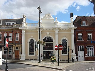
Sudbury is a market town and civil parish in the south west of Suffolk, England, on the River Stour near the Essex border, 60 miles (97 km) north-east of London. It is the largest town in the Babergh local government district and part of the South Suffolk constituency. In 2021 the built-up area had a population of 23,912 and the parish had a population of 13,619.

<span class="mw-page-title-main">River Stour, Suffolk</span> River in East Anglia, England

The River Stour is a major river in East Anglia, England. It is 47 miles (76 km) long and forms most of the county boundary between Suffolk to the north, and Essex to the south. It rises in eastern Cambridgeshire, passes to the east of Haverhill, through Cavendish, Sudbury, Bures, Nayland, Stratford St Mary and Dedham. It becomes tidal just before Manningtree in Essex and joins the North Sea at Harwich.

<span class="mw-page-title-main">Icknield Way</span> Ancient trackway, one of the "Four Highways" of medieval England

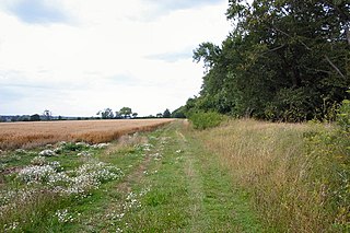
The Icknield Way is an ancient trackway in southern and eastern England that runs from Norfolk to Wiltshire. It follows the chalk escarpment that includes the Berkshire Downs and Chiltern Hills.

<span class="mw-page-title-main">Clare, Suffolk</span> Market town in Suffolk, England

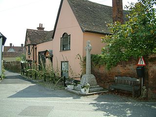
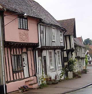
Clare is a market town on the north bank of the River Stour in Suffolk, England. Clare is in southwest Suffolk, 14 miles (23 km) from Bury St Edmunds and 9 miles (14 km) from Sudbury. Clare won Village of the Year in 2010 and Anglia in Bloom award for Best Large Village 2011 for its floral displays in 2011. In March 2015, The Sunday Times and Zoopla placed Clare amongst the top 50 UK rural locations, having "period properties and rich history without the chocolate-box perfection – and the coach trips".

<span class="mw-page-title-main">Nayland</span> Human settlement in England

Nayland is a village and former civil parish, now in the parish of Nayland-with-Wissington, in the Babergh district, in the county of Suffolk, England. It is in the Stour Valley on the Suffolk side of the border between Suffolk and Essex. In 2011 the built-up area had a population of 938.

<span class="mw-page-title-main">Long Melford</span> Village in Suffolk, England

Long Melford, colloquially and historically also referred to as Melford, is a large village and civil parish in the Babergh district, in the county of Suffolk, England. It is on Suffolk's border with Essex, which is marked by the River Stour, 3 miles (4.8 km) from Sudbury, approximately 16 miles (26 km) from Colchester and 14 miles (23 km) from Bury St Edmunds. It is one of Suffolk's "wool towns" and is a former market town. The parish also includes the hamlets of Bridge Street and Cuckoo Tye. In 2011 the parish had a population of 3918.

<span class="mw-page-title-main">Bures St Mary</span> Civil parish in Suffolk, England

Bures St Mary is a civil parish in the Babergh district of the English county of Suffolk. In 2005 it had a population of 940, reducing to 918 at the 2011 Census. The parish covers the eastern part of the village of Bures, the western part being in the Bures Hamlet parish in Essex divided by the River Stour.

<span class="mw-page-title-main">Mistley</span> Village in Essex, England

Mistley is a village and civil parish in the Tendring district of northeast Essex, England. It is around 11 miles northeast of Colchester and is east of, and almost contiguous with, Manningtree. The parish consists of Mistley and New Mistley, both lying beside the Stour Estuary, and Mistley Heath, about a mile to the south. The village is in the parliamentary constituency of Harwich and North Essex. The village has its own parish council.

<span class="mw-page-title-main">Dedham, Essex</span> Village in Essex, England

Dedham is a village in the City of Colchester district of Essex, England. It is near the River Stour, which is the border of Essex and Suffolk. The nearest town to Dedham is the small market town of Manningtree.

<span class="mw-page-title-main">Great Chesterford</span> Human settlement in England

Great Chesterford is a village and civil parish in the Uttlesford district of Essex, England. The village is 13 miles (20 km) north from Bishop's Stortford, 10 miles (16 km) south from Cambridge and about 25 miles (40 km) northwest from the city and Essex county town of Chelmsford.

<span class="mw-page-title-main">Wormingford</span> Human settlement in England

Wormingford is a village and civil parish in the City of Colchester district of Essex, England.

<span class="mw-page-title-main">Icknield Way Path</span> Long-distance footpath in East Anglia, England

The Icknield Way Path or Icknield Way Trail is a long distance footpath and riding route in East Anglia, England. The ancient Icknield Way itself is unique among long-distance trails because it can claim to be ‘the oldest road in Britain’. It consists of prehistoric pathways, ancient when the Romans came; the route is dotted with archaeological remains. It survives today in splendid tracks and green lanes along the ‘chalk spine’ of southern England.

<span class="mw-page-title-main">Icklingham</span> Human settlement in England

Icklingham is a village and civil parish in the West Suffolk district of Suffolk in eastern England. It is located about 7 miles (11 km) north-west of Bury St Edmunds, 4 miles (6.4 km) south-east of Mildenhall and 9 miles (14 km) south-west of Thetford in Norfolk. The village is on the A1101 road between Bury St Edmunds and Mildenhall in the north-west of the county. The area around the village, characterised by a sandy gravel-laden soil, is known as Breckland, though an arm of the fen-like peat follows the River Lark past the village.

The Long Melford–Bury St Edmunds branch line was a railway between Long Melford on the Stour Valley Railway and Bury St Edmunds on the Ipswich to Ely Line. The line opened on 9 August 1865 and closed to passengers on 10 April 1961 and freight on 19 April 1965.

<span class="mw-page-title-main">Black Ditches, Cavenham</span>

Black Ditches is an earthwork close to the village of Cavenham of Suffolk, and part of it is a biological Site of Special Scientific Interest (SSSI). The earthwork is 4.5 miles long between the River Lark at Lackford and the Icknield Way. It is described by the Suffolk Historic Environment Record as having no direct dating evidence but "by analogy with other linear earthworks in the region it is usually assumed to be post Roman".

<span class="mw-page-title-main">Clare Camp</span> Roman fortification in Suffolk, England

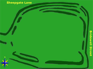
Within the boundaries of Clare Parish lies what appears to be an ancient camp, an earthwork enclosure known variously as Erbury, Clare Camp or the Anglo-Roman fort, at the north end of the town, just to the west of Bridewell Street. The name Erbury is first seen in an inquest and land valuation in 1295, referring to a house, the land around it and a garden. This seemed to be part of the largest and most profitable pasture land in the area, lying outside the town and forming a part of Clare Manor. Erbury means 'earthen fort' from Old English. Bury is a common placename across Britain and refers to a fortified place: it turns up in various guises across Western Europe: borough, burgh, bourg, burg.

<span class="mw-page-title-main">St Peter and St Paul's Church, Clare</span> Church in Suffolk, England

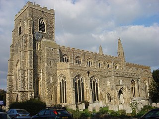
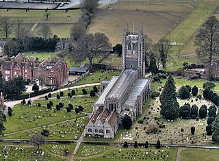
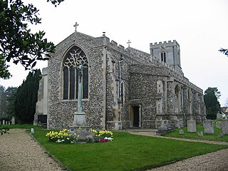
St Peter and St Paul's Church, Clare is a Grade I listed parish church in the Church of England in Clare, Suffolk. It is one of the largest in East Anglia, and is included by Simon Jenkins in his 2009 book England's Thousand Best Churches, where he awards it three stars.

<span class="mw-page-title-main">Wool town</span> Towns and villages associated with the medieval English wool industry

A Wool town is a name given to towns and villages, particularly in Suffolk and north Essex, that were the centre of the woven cloth industry in the Middle Ages.

Nina Crummy is a British archaeologist and artefact specialist, especially of Roman material culture.

Freston is a Neolithic causewayed enclosure, an archaeological site near the village of Freston, in Suffolk, England. Causewayed enclosures were built in England from shortly before 3700 BC until at least 3500 BC; they are characterized by the full or partial enclosure of an area with ditches that are interrupted by gaps, or causeways. Their purpose is not known; they may have been settlements, meeting places, or ritual sites.

References

  1. 1 2 Estimates of Total Population of Areas in Suffolk Archived 19 December 2008 at the Wayback Machine Suffolk County Council: this page is no longer available - update from Census 2011 when available
  2. "Civil Parish population 2011". Neighbourhood Statistics. Office for National Statistics. Retrieved 30 August 2016.
  3. Suffolk Churches website: Simon Knott
  4. http://domesdaymap.co.uk/place/TL7142/wixoe/ Online copy
  5. British Listed Buildings website
  6. Any Wallis, Stour Valley Railway Part 2 Through Time Clare to Shelford and Audeley End, Amberley Publishing 2011 ISBN   978 1-4456-0473-2, pp 13-24
  7. http://www.roman-britain.org/places/wixoe.htm Roman British Organisation
  8. Walford T, An account of a Roman military way, in Essex, and of Roman antiquities found near it, Archaeologica 14, 1803, pp 141-176
  9. St Joseph J K, Air reconnaissance in Roman Britain, 1973-76, Journal of Roman Studies, 1977, 67, 125-61
  10. Jane Plouviez, ‘A hole in the distribution map: the characteristic of small towns in Suffolk’, in Brown, AE (ed), Roman Small Towns in Eastern England and beyond, Oxford: Oxbow Books 1995, pp69-80
  11. Ivan Margary, Roman Roads in Britain, John Baker 1973, 3rd ed. ISBN   0-212-97001-1 pp 243-277
  12. Oxford Archaeology Report No 1283: Excavations at Wixoe Roman Town (Wix 022), September 2012 update
  13. Oxford Archaeology, op cit. p58
  14. Oxford Archaeology, op cit p61
  15. Burnham, Barry, 'Small Towns: the British perspective', in Brown, AE (ed), Roman Small Towns in Eastern England and beyond, Oxford: Oxbow Books 1995, pp 7-14
  16. Oxford Archaeology, op cit, pp 57-73