
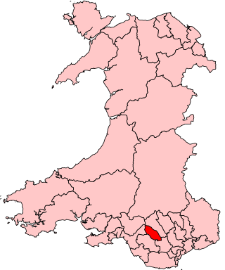
Rhondda Cynon Taf is a county borough in the south-east of Wales. It consists of five valleys: the Rhondda Fawr, Rhondda Fach, Cynon, Taff and Ely valleys, plus a number of towns and villages away from the valleys. Results from the 2011 census showed 19.1% of its 234,410 residents self-identified as having some ability in the use of the Welsh language. The county borough borders Merthyr Tydfil County Borough and Caerphilly County Borough to the east, Cardiff and the Vale of Glamorgan to the south, Bridgend County Borough and Neath Port Talbot to the west and Powys to the north. Its principal towns are - Aberdare, Llantrisant with Talbot Green and Pontypridd, with other key settlements/towns being - Maerdy, Ferndale, Hirwaun, Llanharan, Mountain Ash, Porth, Tonypandy, Tonyrefail and Treorchy.

Maerdy is a village and community in the county borough of Rhondda Cynon Taf, and within the historic county boundaries of Glamorgan, Wales, lying at the head of the Rhondda Fach Valley.
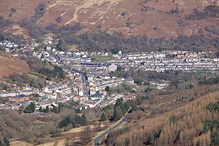
Treorchy is a town and community in Wales. Once a mining town, it retains such characteristics. Situated in the county borough of Rhondda Cynon Taf in the Rhondda Fawr valley. Treorchy is also one of the 16 communities of the Rhondda. It includes the villages of Cwmparc and Ynyswen.

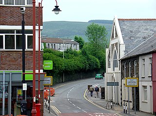
Tonypandy is a town, community and electoral ward located in the county borough of Rhondda Cynon Taf, within the historic county boundaries of Glamorgan, Wales, lying in the Rhondda Fawr Valley. A former industrial coal mining town, the town was the scene of the 1910 Tonypandy riots.
Ynysybwl is a village in Cwm Clydach in Wales. It is situated in the county borough of Rhondda Cynon Taf, roughly 15 miles (24 km) north-north-west of Cardiff, 4 miles (6 km) north of Pontypridd and 16 miles (26 km) south of Merthyr Tydfil, and forms part of the community of Ynysybwl and Coed-y-Cwm.
Llwynypia is a village and community in Rhondda Cynon Taf, Wales, near Tonypandy in the Rhondda Fawr Valley. Before 1850 a lightly populated rural farming area, Llwynypia experienced a population boom between 1860 and 1920 with the sinking of several coal mines after the discovery of large coal deposits throughout the Rhondda Valleys.

Ynyshir is a village and community located in the Rhondda Valley, within Rhondda Cynon Taf, South Wales. The name of the village means "long island" in Welsh and takes its name from a farm in the area, falling within the historic parishes of Ystradyfodwg and Llanwynno (Llanwonno). The community of Ynyshir lies between the small adjoining village of Wattstown and the larger town of neighbouring Porth.
Rhondda, or the Rhondda Valley, is a former coalmining area in South Wales, historically in the county of Glamorgan. It takes its name from the River Rhondda, and embraces two valleys – the larger Rhondda Fawr valley and the smaller Rhondda Fach valley – so that the singular "Rhondda Valley" and the plural are both commonly used. The area forms part of the South Wales Valleys. From 1897 until 1996 there was a local government district of Rhondda. The former district at its abolition comprised sixteen communities. Since 1996 these sixteen communities of the Rhondda have been part of Rhondda Cynon Taf County Borough. The area of the former district is still used as the Rhondda Senedd constituency and Westminster constituency, having an estimated population in 2020 of 69,506. It is most noted for its historical coalmining industry, which peaked between 1840 and 1925. The valleys produced a strong Nonconformist movement manifest in the Baptist chapels that moulded Rhondda values in the 19th and early 20th centuries. It is also known for its male voice choirs and in sport and politics.

Ferndale is a town and community located in the Rhondda Valley in the county borough of Rhondda Cynon Taf, Wales. Neighbouring villages are Blaenllechau, Maerdy and Tylorstown. Ferndale was industrialised in the mid-19th century. The first coal mine shaft was sunk in 1857 and was the first community to be intensively industrialised in the Rhondda Valley.
Ystrad is a village and community in the Rhondda Fawr valley, Rhondda Cynon Taf, Wales.

Tylorstown (Pendyrus) is a village and community located in the Rhondda valley, in the county borough of Rhondda Cynon Taf, Wales. It is neighboured by the villages of Blaenllechau, Ferndale, Penrhys, Pontygwaith and Stanleytown.

Dinas is a village near Tonypandy in the county borough of Rhondda Cynon Taf, Wales. Dinas is often referred to as Dinas Rhondda to avoid confusion with Dinas Powys in the Vale of Glamorgan. The word dinas in Modern Welsh means "city", but here it means "hill fort".
Clydach Vale is a village in the community of Cwm Clydach, northwest of Tonypandy in the county borough of Rhondda Cynon Taf, within the Rhondda Valley, Wales. It is named for its situation on the Nant Clydach, a tributary of the River Rhondda. The village is deemed part of the Tonypandy built-up area by the Office for National Statistics and comes under the Tonypandy post town.

Rhondda Cynon Taf County Borough Council is the governing body for Rhondda Cynon Taf, one of the Principal Areas of Wales. The council headquarters are located in the community of Cwm Clydach on the outskirts of Tonypandy.
Cymmer is a village and community in the Rhondda Valley, Wales. It is so named because of being located at the 'confluence' of the Rhondda Fawr and Rhondda Fach river valleys. Several collieries were opened here in the middle part of the nineteenth century. A coal mine disaster in 1856 resulted in 114 casualties, and the lack of payment of any compensation to the miners' families caused bitter feelings in the community.

Penygraig is a village and community in the Rhondda Valley in the county borough of Rhondda Cynon Taf, Wales. As a community Penygraig contains the neighbouring districts of Dinas, Edmondstown, Penrhiwfer and Williamstown. Penygraig is within the historic county boundaries of Glamorgan. The name Penygraig is Welsh for 'head of the rock'.
Pentre is a village, community and electoral ward near Treorchy in the Rhondda valley, falling within the county borough of Rhondda Cynon Taf, Wales. The village's name is taken from the Welsh word Pentref, which translates as homestead, though Pentre is named after a large farm that dominated the area before the coming of industrialisation. The community takes in the neighbouring village of Ton Pentre.
Cwm Clydach is a community and electoral ward to the northwest of Tonypandy in Rhondda Cynon Taf, Wales. The community and ward covers the valley of the Nant Clydach, which includes the cojoined villages of Clydach Vale and Blaenclydach.


