The London Borough of Croydon is a London borough in south London, part of Outer London. It covers an area of 87 km2 (33.6 sq mi). It is the southernmost borough of London. At its centre is the historic town of Croydon from which the borough takes its name; while other urban centres include Coulsdon, Purley, South Norwood, Norbury, New Addington, Selsdon and Thornton Heath. Croydon is mentioned in Domesday Book, and from a small market town has expanded into one of the most populous areas on the fringe of London. The borough is now one of London's leading business, financial and cultural centres, and its influence in entertainment and the arts contribute to its status as a major metropolitan centre. Its population is 390,719, making it the largest London borough and sixteenth largest English district.

Waddon is a neighbourhood in the London Borough of Croydon, at the western end of the town of Croydon. The area borders the London Borough of Sutton.

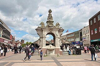
Wallington is a town in the London Borough of Sutton, South London, England, 9.7 miles (15.6 km) south-west of Charing Cross. Before the Municipal Borough of Beddington and Wallington merged into the London Borough of Sutton in Greater London in 1965, it was part of the county of Surrey. Wallington is a post town in the SM postcode area.

Croydon Airport was the UK's only international airport during the interwar period. It opened in 1920, located in Croydon, then part of Surrey. Built in a Neoclassical style, it was developed as Britain's main airport, handling more cargo, mail, and passengers than any other UK airport at the time. Innovations at the site included the world's first air traffic control and the first airport terminal. During World War II the airport was named RAF Croydon as its role changed to that of a fighter airfield during the Battle of Britain; and in 1943 RAF Transport Command was founded at the site, which used the airport to transport thousands of troops into and out of Europe.
The Metropolitan Borough of Dudley is a metropolitan borough of West Midlands, England. It was created in 1974 following the Local Government Act 1972, through a merger of the existing Dudley County Borough with the municipal boroughs of Stourbridge and Halesowen.

Sandwell Metropolitan Borough Council was created in 1974 to administer the newly formed Metropolitan Borough of Sandwell, in the West Midlands county of England.

Croydon is a large town in South London, England, 9.4 miles (15.1 km) south of Charing Cross. Part of the London Borough of Croydon, a local government district of Greater London, it is one of the largest commercial districts in Greater London, with an extensive shopping district and night-time economy. The entire town had a population of 192,064 as of 2011, whilst the wider borough had a population of 384,837.

Castle Vale is a housing estate located between Erdington, Minworth and Castle Bromwich. Currently Castle Vale makes up the Castle Vale Ward of Birmingham City Council which is part of Erdington constituency, 6 miles (9 km) northeast of Birmingham city centre in England. The area has an approximate population of 10,000 people and has a distinctly modern residential character stemming from its history as a postwar overspill estate.

Chelmsley Wood, sometimes called just Chelmsley, is a town and civil parish in the Metropolitan Borough of Solihull, West Midlands, England, with a population of 12,453. It is located near Birmingham Airport and the National Exhibition Centre. It lies about eight miles east of Birmingham City Centre and 5 miles to the north of Solihull. The town is also close to both Coleshill and Water Orton in Warwickshire, the county the area was historically part of.
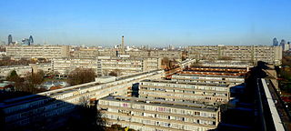
The Aylesbury Estate is a large housing estate located in Walworth, South East London.
Sighthill is a neighbourhood in the Scottish city of Glasgow. It is situated north of the River Clyde and is part of the wider Springburn district in the north of the city. It is bordered to the north by Cowlairs, to the east by the Springburn Bypass road and the Royston neighbourhood, to the west by the Glasgow to Edinburgh via Falkirk Line and to the south by the Townhead interchange of the M8 Motorway.
Mitcham Common is 182 hectares (460 acres) of common land situated in south London. It is predominantly in the London borough of Merton, with parts straddling the borders of Croydon and Sutton. It is designated a Site of Metropolitan Importance for Nature Conservation.

Hackbridge is a suburb in the London Borough of Sutton, south-west London, just over two miles north-east of the town of Sutton itself. It is 8.8 miles (15 km) south-west of Charing Cross.

Pollards Hill is a small residential district straddling south London boroughs of Croydon and Merton between Mitcham, Norbury and Thornton Heath. The boundary of the two boroughs is a street named Recreation Way. No roads directly cross the Croydon and Merton divide, and streets were planned according to borough, leading to differing architectural or building schemes. It lends its name to a ward of the London Borough of Merton.
Pype Hayes is a modern housing estate area in the east of the Erdington district of Birmingham. It is within the Tyburn ward. Covering the postcodes of B24 and B76.
South Acton is an area in Acton, West London, 6.4 miles (10.3 km) west of Charing Cross. At the 2001 census, Acton, comprising the wards of East Acton, Acton Central, South Acton and Southfield, had a population of 53,689 people.
The 1950s and 1960s saw the construction of numerous brutalist apartment blocks in Sheffield, England. The Sheffield City Council had been clearing inner-city residential slums since the early 1900s. Prior to the 1950s these slums were replaced with low-rise council housing, mostly constructed in new estates on the edge of the city. By the mid-1950s the establishment of a green belt had led to a shortage of available land on the edges of the city, whilst the government increased subsidies for the construction of high-rise apartment towers on former slum land, so the council began to construct high-rise inner city estates, adopting modernist designs and industrialised construction techniques, culminating in the construction of the award-winning Gleadless Valley and Park Hill estates.
Stonegrove and Spur Road Estates (Stonegrove), Edgware, are situated on the edge of the green belt at the very northern edge of the London Borough of Barnet, close to Stanmore tube station and adjoining the London Borough of Harrow. The estates were built in the 60s and 70s, and are a mixture of 11-storey tower blocks and four-storey maisonette blocks.
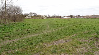
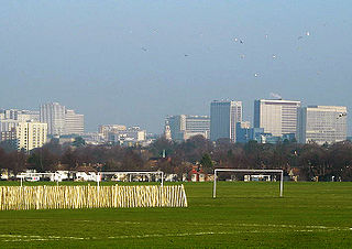
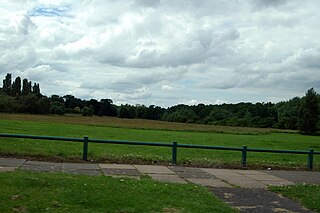
Roundshaw Downs is a 52.7-hectare (130-acre) Site of Metropolitan Importance for Nature Conservation Roundshaw in the London Boroughs of Sutton and Croydon. An area of 19.6 hectares in Sutton is also a local nature reserve. In the nineteenth century the area was farmland, and in the first half of the twentieth it was Croydon Airport.

Public housing in the United Kingdom, also known as council housing or social housing, provided the majority of rented accommodation until 2011 when the number of households in private rental housing surpassed the number in social housing. Dwellings built for public or social housing use are built by or for local authorities and known as council houses. Since the 1980s non-profit housing associations became more important and subsequently the term "social housing" became widely used, as technically council housing only refers to housing owned by a local authority, though the terms are largely used interchangeably.


