
Coulsdon is a town in south London, England, within the London Borough of Croydon. Coulsdon was an ancient parish in the county of Surrey that included the settlements of Purley and Kenley. It was merged with Sanderstead in 1915 to form the Coulsdon and Purley Urban District and has formed part of Greater London since 1965.

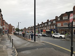
Purley is an area of the London Borough of Croydon in London, England, 11.7 miles (18.8 km) south of Charing Cross, with a history going back at least 800 years. It was originally granted as an estate from holdings at Sanderstead and until as a district of Surrey and then, with neighbouring Coulsdon, as an urban district that became an electoral ward of the London Borough of Croydon, becoming part of the ceremonial county of London, in 1965. In 2018 the Purley ward was divided into two: Purley and Woodcote, and Purley Oaks and Riddlesdown.
Selsdon is an area in South London, England, located in the London Borough of Croydon, in the ceremonial county of Greater London. Prior to 1965 it was in the historic county of Surrey. It now has the character of a suburb and sits at a high elevation, bordering downland.
Tandridge is a local government district in east Surrey, England. Its council is based in Oxted, although the largest settlement is Caterham; other notable settlements include Warlingham, Godstone and Lingfield. In mid-2019, the district had an estimated population of 88,129.

Warlingham is a village and civil parish in the Tandridge district of Surrey, England, 14 miles (23 km) south of London and 22 miles (35 km) east of Guildford. Warlingham is the centre of a civil parish that includes Hamsey Green to the north. Caterham is 2 miles (3.2 km) to the southwest.

Kenley is a residential suburb within the London Borough of Croydon. It is located 13 miles (21 km) south of Charing Cross and within the southern boundary of London, England. Surrounded by the Metropolitan Green Belt on three sides, it includes the large open spaces of Kenley Common and Kenley Aerodrome. Kenley was part of the ancient parish of Coulsdon in the county of Surrey and was connected to central London by rail in 1856. As the population of the area was growing, it became part of Coulsdon and Purley Urban District in 1915 and has formed part of Greater London since 1965. At the 2011 Census, Kenley had a population of 14,966.

Sanderstead is a village and medieval-founded church parish at the southern end of Croydon in south London, England, within the London Borough of Croydon, and formerly in the historic county of Surrey, until 1965. It takes in Purley Downs and Sanderstead Plantation, an area of woodland that includes the second-highest point in London. Sanderstead sits above a dry valley at the edge of the built-up area of Greater London. Cementing its secular identity from the late 19th century until abolition in 1965 it had a civil parish council. The community had a smaller farming-centred economy until the mid 19th century.

The Oxted line is a railway in southern England and part of the Southern franchise. The railway splits into two branches towards the south and has direct trains throughout to London termini.

East Surrey is a constituency represented in the House of Commons of the UK Parliament since 2019 by Claire Coutinho, a Conservative who formerly served as Secretary of State for Energy Security and Net Zero. The seat covers an affluent area in the English county of Surrey.

Whyteleafe South railway station serves part of the suburban village of Whyteleafe in the district of Tandridge, Surrey, England. The station and all trains serving it are operated by Southern, and it is on the Caterham Line 18 miles 18 chains (29.3 km) from Charing Cross.
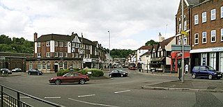
Caterham is a town in the Tandridge district of Surrey, England. The town is administratively divided into two: Caterham on the Hill, and Caterham Valley, which includes the main town centre in the middle of a dry valley but rises to equal heights to the south. The town lies close to the A22, 21 miles from Guildford and 6 miles south of Croydon, in an upper valley cleft into the dip slope of the North Downs. Caterham on the Hill is above the valley to the west.
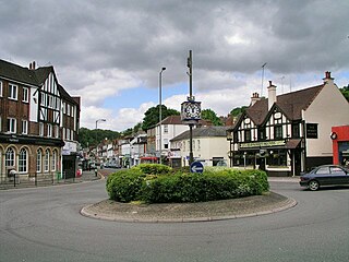
Whyteleafe is a village in the district of Tandridge, Surrey, England, with a few streets falling inside the London Borough of Croydon. The village, in a dry valley of the North Downs, has three railway stations. Neighbouring villages and towns include Woldingham, Caterham, Coulsdon, Warlingham, and Kenley. To the west are Kenley Aerodrome, Kenley Common, Coxes Wood, and Blize Wood. To the east are Riddlesdown, the Dobbin and Marden Park.

Coulsdon and Purley Urban District was a local government district in northeast Surrey from 1915 to 1965. The local authority was Coulsdon and Purley Urban District Council. The former area of the district is now mostly part of the London Borough of Croydon in Greater London, with parts in the Tandridge District and the Borough of Reigate and Banstead in Surrey.

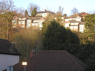
Riddlesdown is a place in the London Borough of Croydon, one mile east from the centre of its post town of Purley. The name applies to the residential district and to the green space maintained by the City of London Corporation which is also known as Riddlesdown Common.

Farleigh is a village and former civil parish, now in the parish of Chelsham and Farleigh in the Tandridge district of Surrey, England. It is located in the North Downs AONB and the Metropolitan Green Belt, 4.5 miles (7.2 km) south east of Croydon, 13.4 miles (21.6 km) south of London and 25 miles (40 km) WNE of Surrey's county town, Guildford. In 1961 the parish had a population of 1285.

The A2022 is a non-primary road in England. It runs south-west into the foothills of the North Downs from West Wickham in the London Borough of Bromley through Selsdon, Sanderstead, Addington, Purley, the Woodcote part of that town, Banstead in Surrey and Epsom Downs through which it descends to a similar altitude as at its beginning to end at Epsom.

Woodmansterne is a village in the borough of Reigate and Banstead, Surrey, bordering Greater London, England. It sits on a small plateau of and a southern down slope of the North Downs and its ecclesiastical parish borders continue to span old boundaries and reach into Chipstead, Coulsdon and Wallington.

Chelsham is a village and former civil parish, now in the parish of Chelsham and Farleigh and the Tandridge district of Surrey, England. It is located in the Metropolitan Green Belt, 15.3 miles (24.6 km) from London, 3 miles (4.8 km) from Oxted and 23.8 miles (38.3 km) from Guildford. In 1961 the parish had a population of 1285.
The Southern Heights Light Railway (SHLR) was to have been a speculative London area suburban electric railway between Orpington, Kent and Sanderstead, Surrey. It was authorised in 1928 under the Light Railways Act 1896, but ultimately not constructed. The engineer was to have been Colonel Holman Fred Stephens, heavily involved in the promotion of light railways.


