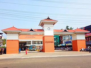
Perambra

Last updated

Perambra
Town
India Kerala location map.svg
Red pog.svg
Perambra
Location in Kerala, India
India location map.svg
Red pog.svg
Perambra
Perambra (India)
Coordinates: 11°33′27″N75°45′38″E / 11.5575°N 75.7605°E / 11.5575; 75.7605
Pba twn.jpg
CountryFlag of India.svg India
State Kerala
District Kozhikode
Government
  TypePanchayat
  BodyPerambra Grama Panchayat
Area
  Total26.12 km2 (10.08 sq mi)
Population
 (2011) [1]
  Total32,784
  Density1,300/km2 (3,300/sq mi)
Languages
  Official Malayalam, English
Time zone UTC+5:30 (IST)
PIN
673 525
Telephone code91 496
ISO 3166 code IN-KL
Vehicle registration KL-77
Website www.kozhikode.nic.in

Perambra is a major town in Koyilandy taluk of Kozhikode district in North Malabar region of Kerala state, India. It is one of the 140 assembly constituencies in Kerala, and one of the 12 block Panchayats in Kozhikode district. Perambra lies almost at the centre of the district. The area which was formerly known as Payyormalanadu, eventually became Perambra. In the Northern Songs, there are references to the Payyormalanadu of Old Kurumbranadu.

Contents

Demographics

As of 2011 Indian Census,Perambra had a population of 32,784.Perambra has an average literacy rate of 95.5%,higher than the national average of 74%.

Religion in Perambra (2011)
Hinduism
68.74%
Islam
29.41%
Christianity
1.65%
No religion
0.14%
Others
0.05%

Block Panchayat

perambra block panchayat Perambra Block.jpg
perambra block panchayat

The block has a population of 1,71,433; (86,019 males and 85414 females). The Perambra block has seven panchayats: Changaroth, Cheruvannur, Kayanna, Koothali, Chakkittapara, Nochad and Perambra.

Transportation

Perambra Vadakara Road Perambra Vadakara Road.jpg
Perambra Vadakara Road

Perambra town connects to other parts of India through Koyilandy, kozhikode and Vadakara. The nearest airports are at Kannur and Kozhikode. The nearest railway station is at Koyiandy. The national highway no.66 passes through Koyilandy and the northern stretch connects to Mangalore, Goa and Mumbai. The southern stretch connects to Cochin and Trivandrum.

Educational History

The social reform movements, missionary work, drinking places, and service of the ground clerk are all factors that contribute to the educational activities of the Perambra block in the early stages. A board school was established in Perambra as a result of the activities of the Basel Mission. Groundbreaking schools, mosques and monastic schools existed in Cheruvannur, Nochat, Kayanna, Koothali, Changaroth and Perambra. Growing up in the traditional tradition of indigenous medicine, astrology, carpentry, veterinary medicine, music and dance, informal education contributed to social development. As colonial education began to proliferate, informal and traditional education became a setback. The activities of the Malabar District Board have expanded and formal educational institutions have emerged. The oldest school on the block was the Muipotpol ALP School, established in 1860 at Muipotpot in Cheruvannur. During the period when the caste system was rampant, the Pancham schools, which were set up for the Harijans in the villages of Perambra and Cheruvannur, did not work for many social reasons. The lower castes have been admitted to public schools as part of the agitations against the caste system and practices of untouchability. The schools started from 1944 in the settlement area of Chakkitapara.

PHSS C.K.G. Memorial Government College, Perambra, Kerala, India (2020).jpg
PHSS PHSS.jpg
PHSS

There are 50 LP schools, 22 UP schools and 9 high schools in Block Panchayat. Established in 1975, CKGM Government College has facilities for undergraduate and postgraduate studies. Perambra High School has been upgraded from 1991 to Higher Secondary School.

History Of Perambra

Perambra 1981.jpg
Permbra old.jpg

The area which was formerly known as Payyarmalanadu, eventually became Perambra. In the Northern Songs, there are references to the Paayyormalanadu of Old Kurumbranadu.

Notable people

P.K.Appa Nair, Advocate and Politician

K.A.Devassy, Advocate and Politician

See also

Related Research Articles

<span class="mw-page-title-main">Balussery</span> Town in Kerala, India

Balussery is a town located about 25 km northeast of Kozhikode city and lies on State Highway 34. It is one of the 12 block Panchayats in Kozhikode district. Balussery is the Northeast side entry of Calicut city.

<span class="mw-page-title-main">Payyoli</span> Municipality in Kerala, India

Payyoli is a municipality town on the Malabar Coast of Kozhikode district in the South Indian state of Kerala. Payyoli is famous for being the hometown of athlete PT Usha, who is nicknamed as the Payyoli Express. It is a town in Quilandy Taluk, Kozhikode District.

<span class="mw-page-title-main">Koyilandy</span> Town in Kerala, India

Koyilandy is a major town municipality and a taluk in Kozhikode district, Kerala on the Malabar Coast. The historical town is located right in the middle of the coast of Kozhikode district, between Kozhikode (Calicut) and Kannur, on National Highway 66.

Meppayur is a town in Kozhikode district of Kerala state, South India.

Kottur is a grama panchayat and a community development block in the Kozhikode district of Kerala, India.

<span class="mw-page-title-main">Kulathuvayal</span> Village in Kerala, India

Kulathuvayal is a place near Perambra in Kozhikode district of Kerala state, India. Administratively, Kulathuvayal comes under the Chakkittapara panchayat, Perambra block panchayat and Koyilandy Taluk.

Chakkittapara is a panchayat in the Kozhikode district of Kerala state, India. Chakkittapara borders Wayanad district to the east. Administratively, Chakkittapara comes under the Perambra block panchayat and Koyilandy Taluk, containing 15 wards and destinations like Kulathuvayal, Peruvannamuzhi, Chempanoda, Poozhithode, Muthukadu, Koovapoyil, Narinada, Chempra, and Pannikkottoor.

<span class="mw-page-title-main">Thiruvangoor</span> Village in Kerala, India

Thiruvangoor (തിരുവങ്ങൂർ) is a small village 16 kilometres (9.9 mi) away from Kozhikode, Kerala, India. It lies to the east of the Arabian Sea (Kappad) and west of Kuniyil Kadavu. Portuguese navigator Vasco de Gama is believed to have landed near Thiruvangoor, at Kappad, during one of his voyages, on 20 May 1498. Thiruvangoor lies on National highway 66.Nearby major towns are Atholi and Koyilandy. The Kuniyil Kadavu Bridge allows for transportation between Thiruvangoor and Atholi town.

Changaroth is a village in Kozhikode district in the state of Kerala, India.

Keezhariyur is a village near Koyilandy in Kozhikode district, that lies on the eastern shore of Akalapuzha Lake. This village is famous for the bomb case happened during Independence struggle. Malayalam is the Local Language here. Keezhariyur has its own post office and the Pincode is 673307. Keezhriyur Panchayat was formed on 27 September 1968.

Koothali is a village near Perambra in Kozhikode district in the state of Kerala, India, and the traditional seat of the Koothali Nair.

<span class="mw-page-title-main">Maniyur</span> Grama Panchayath in Kerala, India

Maniyur Grama Panchayat is located in Vadakara Taluk, in the Kozhikode district in the state of Kerala, India. It covers an area of 31.03 km2.

Naduvannur is a Grama Panchayath and a Census town in Kozhikode district in the state of Kerala, India. It lies at the center of the district. Naduvannur is part of Kozhikode Urban Agglomeration. The name Naduvannur denotes that it was the center of the territory of Kurumbranad. 'Nadu' means center and ur(oor) means place.

Nochad is a village in Kozhikode district in the state of Kerala, India.

Ulliyeri is a village in Kozhikode district in the state of Kerala, India. Ulliyeri is between Koyilandy and Balussery and also between Kuttiyadi and Kozhikode.

Orkkatteri is a small town in Kozhikode district in the North Malabar region of state of Kerala, India. This is the center town for Eramala grama panchayath.

Cheruvannur one of the 78 grama panchayats of Kozhikode district, lies between North Latitude 11° 32′ 37.11" and 11° 36′ 4.67", East Longitude 75° 40′ 26.32" and 75° 43′ 55.22". It has a total area of 21.61 square kilometers. The adjoining grama panchayats are Thiruvallur and Velom in the north, Perambra in the east, Nochad, Meppayur, and Thurayur in the south, Maniyur and Thiruvallur in the west.

Panangad Grama panchayat is one among the 75 grama panchayat in Kozhikode district. It is near Balussery and coming under Balussery block.

Muyippoth is a beautiful agricultural village in Cheruvannur Grama Panchayat, a part of Perambra Legislative Assembly Constituency in Koyilandi Taluk of Kozhikode District. Surrounded by the Kuttyadi river on three sides, about 40% of the area of Muyippoth village is vast paddy fields. There are many scenic spots in this village, which also includes small hills and plains. Muyippoth is also an important cultural center of Kozhikode district: this village has given birth to many famous personalities in various fields.

Kadiyangad is a village near Perambra in Kozhikode district, Kerala.

References

  1. dop.lsgkerala.gov.in › node കോഴിക്കോട് ജില്ലയിലെ ഗ്രാമ ...