Onion Creek, Austin, Texas

Last updated
Onion Creek, Texas
Former CDP
Onion Creek, Austin, Texas
Neighborhood Boundaries
USA Texas location map.svg
Red pog.svg
Onion Creek, Texas
Location within the state of Texas
Coordinates: 30°07′47″N97°47′18″W / 30.12972°N 97.78833°W / 30.12972; -97.78833
Country United States
State Texas
County Travis
Area
  Total3.2 sq mi (8.4 km2)
  Land3.2 sq mi (8.4 km2)
  Water0.0 sq mi (0.0 km2)
Elevation
[1]
594 ft (181 m)
Population
 (2000)
  Total2,116
  Density656.1/sq mi (253.3/km2)
Time zone UTC-6 (Central (CST))
  Summer (DST) UTC-5 (CDT)
FIPS code 48-54063 [2]
GNIS feature ID2408990 [1]

Onion Creek is a neighborhood in Austin, Texas, United States.

Contents

Onion Creek is also the name of a creek that starts in Hays County and empties into the Colorado River.

Geography

Onion Creek is located 10 miles (16 km) south of downtown Austin.

According to the United States Census Bureau, the CDP has a total area of 3.2 square miles (8.3 km2), all of it land.

Demographics

As of the census [2] of 2000, there were 2,116 people, 1,002 households, and 742 families living in the CDP. The population density was 656.1 inhabitants per square mile (253.3/km2). There were 1,038 housing units at an average density of 321.9 per square mile (124.3/km2). The racial makeup of the CDP was 93.10% White, 1.18% African American, 0.28% Native American, 1.13% Asian, 0.05% Pacific Islander, 2.65% from other races, and 1.61% from two or more races. Hispanic or Latino of any race were 9.12% of the population.

There were 1,002 households, out of which 12.6% had children under the age of 18 living with them, 69.5% were married couples living together, 3.6% had a female householder with no husband present, and 25.9% were non-families. 21.9% of all households were made up of individuals, and 11.7% had someone living alone who was 65 years of age or older. The average household size was 2.11 and the average family size was 2.41.

In the CDP, the population was spread out, with 10.0% under the age of 18, 3.4% from 18 to 24, 18.0% from 25 to 44, 40.3% from 45 to 64, and 28.3% who were 65 years of age or older. The median age was 55 years. For every 100 females, there were 89.3 males. For every 100 females age 18 and over, there were 88.1 males.

The median income for a household in the CDP was $87,924, and the median income for a family was $97,151. Males had a median income of $70,260 versus $45,781 for females. The per capita income for the CDP was $54,758. About 1.0% of families and 1.2% of the population were below the poverty line, including none of those under age 18 and 2.1% of those age 65 or over.

Related Research Articles

Willow Creek is a census-designated place (CDP) in Copper River Census Area, Alaska, United States. At the 2020 census the population was 190, down from 191 in 2010.

<span class="mw-page-title-main">Mesquite Creek, Arizona</span> CDP in Mohave County, Arizona

Mesquite Creek is an unincorporated community and census-designated place (CDP) in Mohave County, Arizona, United States. The population was 403 at the 2020 census.

<span class="mw-page-title-main">Dixon Lane-Meadow Creek, California</span> Census-designated place in California, United States

Dixon Lane-Meadow Creek is a census-designated place (CDP) in Inyo County, California, United States. The population was 2,645 at the 2010 census, down from 2,702 at the 2000 census.

<span class="mw-page-title-main">North El Monte, California</span> Census-designated place in California, United States

North El Monte is a census-designated place (CDP) in the San Gabriel Valley, in Los Angeles County, California, United States. The population was 3,723 at the 2010 census, up from 3,703 at the 2000 census.

<span class="mw-page-title-main">South San Gabriel, California</span> Census-designated place in California, United States

South San Gabriel is a census-designated place (CDP) in Los Angeles County, California, United States. The population was 8,070 at the 2010 census, up from 7,595 at the 2000 census.

<span class="mw-page-title-main">Mission Hills, Santa Barbara County, California</span> Census-designated place in the U.S. state of California

Mission Hills is a census-designated place (CDP) in Santa Barbara County, California, a short distance north of Lompoc on Highway 1. The population was 3,576 at the 2010 census, up from 3,142 at the 2000 census.

<span class="mw-page-title-main">Ducor, California</span> Census-designated place in California, United States

Ducor is a census-designated place (CDP) in Tulare County, California, United States. The population was 616 at the 2020 census, up from 612 at the 2010 census. Ducor is an abbreviation of an earlier name, Dutch Corners, which was given because several early settler families were German. The word "Dutch" in this case derives from German deutsch "German".

<span class="mw-page-title-main">South Wallins, Kentucky</span> Census-designated place in Kentucky, United States

South Wallins is an unincorporated community and census-designated place (CDP) in Harlan County, Kentucky, United States. The population was 859 at the 2010 census, down from 996 at the 2000 census.

<span class="mw-page-title-main">Escatawpa, Mississippi</span> Census-designated place in Mississippi, United States

Escatawpa is an unincorporated community and census-designated place (CDP) in Jackson County, Mississippi, United States. It is part of the Pascagoula Metropolitan Statistical Area. The population was 3,254 at the 2020 census.

<span class="mw-page-title-main">Collinsville, Mississippi</span> Census-designated place in Mississippi, United States

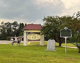
Collinsville is an unincorporated community and census-designated place (CDP) in Lauderdale County, Mississippi, United States. The population was 1,984 at the 2020 census.

<span class="mw-page-title-main">Helena West Side, Montana</span> Census-designated place in Montana, United States

Helena West Side is a census-designated place (CDP) in Lewis and Clark County, Montana, United States. The population was 1,637 at the 2010 census, down from 1,711 at the 2000 census due to annexation of part of the CDP by the city of Helena. It is part of the Helena Micropolitan Statistical Area.

<span class="mw-page-title-main">Golden Triangle, New Jersey</span> Populated place in Camden County, New Jersey, US

Golden Triangle is an unincorporated community and census-designated place (CDP) located within Cherry Hill, in Camden County, in the U.S. state of New Jersey. As of the 2010 United States Census, the CDP's population was 4,145.

<span class="mw-page-title-main">Turnersville, New Jersey</span> Populated place in Gloucester County, New Jersey, US

Turnersville is an unincorporated community and census-designated place (CDP) located within Washington Township, in Gloucester County, in the U.S. state of New Jersey. As of the 2010 United States census, the CDP's population was 3,742.

<span class="mw-page-title-main">Bolindale, Ohio</span> Census-designated place in Ohio, United States

Bolindale is an unincorporated community and census-designated place in southern Howland Township, Trumbull County, Ohio, United States. The population was 1,921 at the 2020 census. It is part of the Youngstown–Warren metropolitan area.

<span class="mw-page-title-main">Barton Creek, Texas</span> CDP in Texas, United States

Barton Creek is a census-designated place (CDP) in Travis County, Texas, United States. As of the 2020 census, the CDP population was 3,356.

<span class="mw-page-title-main">Montezuma Creek, Utah</span> Census-designated place in Utah, United States

Montezuma Creek is a census-designated place (CDP) in San Juan County, Utah, United States. The population was 335 at the 2010 census, a decrease from the 2000 figure of 507.

<span class="mw-page-title-main">Canyon Creek, Washington</span> CDP in Washington, United States

Canyon Creek is a census-designated place (CDP) in Snohomish County, Washington, United States. The population was 3,445 at the 2020 census, up from 3,200 at the 2010 census. Prior to the 2010 census, the CDP was known as Jordan Road-Canyon Creek.

<span class="mw-page-title-main">May Creek, Washington</span> CDP in Washington, United States

May Creek is a census-designated place (CDP) in Snohomish County, Washington, United States. The population was 849 at the 2020 census.

<span class="mw-page-title-main">Woods Creek, Washington</span> CDP in Washington, United States

Woods Creek is a census-designated place (CDP) in Snohomish County, Washington, United States. The population was 6,017 at the 2020 census.

<span class="mw-page-title-main">Tainter Lake, Wisconsin</span> CDP in Wisconsin, United States

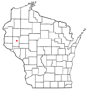
Tainter Lake is a census-designated place (CDP) in part of the Town of Tainter, Dunn County, Wisconsin, and part of the Town of Red Cedar, Dunn County, Wisconsin, United States. The population was 2,550 at the 2020 census.

References

  1. 1 2 U.S. Geological Survey Geographic Names Information System: Onion Creek, Austin, Texas
  2. 1 2 "U.S. Census website". United States Census Bureau . Retrieved 2008-01-31.