Upper Miocene Migeulito member exposed at Hazard Reef, Montana de Oro State Park. This is the first onshore outcrop of the Monterey Formation south of the Monterey Peninsula. Large exposures continue south along the coast, often associated with important oilfields.Tar "volcano" in the old Carpinteria Asphalt mine. Heavy oil exudes from joint cracks in the upturned Monterey shale forming the floor of mine. 1906 photo, U.S. Geological Survey Bulletin 321
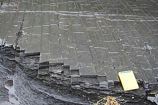
Fold in Monterey FormationFossil crab (Pinnixa galliheri), Monterey Formation, Pacific Grove, California. Carapace is about 3cm. wide.Diatomite (diatomaceous earth), Monterey Formation, from a diatomite quarry just south of LompocHeavy oil saturated sandstone from a unit of the Monterey Formation.
The Monterey Formation is an extensive Miocene oil-rich geologicalsedimentary formation in California, with outcrops of the formation in parts of the California Coast Ranges, Peninsular Ranges, and on some of California's off-shore islands. The type locality is near the city of Monterey, California.[1] The Monterey Formation is the major source-rock for 37 to 38billion barrels of oil in conventional traps such as sandstones.[2] This is most of California's known oil resources.[3] The Monterey has been extensively investigated and mapped for petroleum potential, and is of major importance for understanding the complex geological history of California. Its rocks are mostly highly siliceous strata that vary greatly in composition, stratigraphy, and tectono-stratigraphic history.
The US Energy Information Administration (EIA) estimated in 2014 that the 1,750 square mile Monterey Formation could, as an unconventional resource, yield about 600million barrels of oil, from tight oil contained in the formation, down sharply from their 2011 estimate of a potential 15.4billion barrels.[4][5] An independent review by the California Council on Science and Technology found both of these estimates to be "highly uncertain."[6] Despite intense industry efforts, there has been little success to date (2013) in producing Monterey-hosted tight oil/shale oil, except in places where it is already naturally fractured, and it may be many years, if ever, before the Monterey becomes a significant producer of shale oil.[7]
The Monterey Formation strata vary. Its lower Miocene members show indications of weak coastal upwelling, with fossil assemblages and calcareous-siliceous rocks formed from diatoms and coccolithophorids. Its middle and upper Miocene upwelling-rich assemblages, and its unique highly siliceous rocks from diatom-rich plankton, became diatomites, porcelainites, and banded cherts.[8]
Shale oil resources and exploitation
The Monterey formation has long been recognized as the primary source of the oil produced from other formations in Southern California; the Monterey itself has been very productive where it is naturally fractured. Since 2011, the possibility that hydraulic fracturing might make the Monterey Shale productive over large areas has gained widespread public attention.[9]
According to the US Energy Information Administration (EIA) in 2011, the 1,750-square-mile (4,500km2) Monterey Shale Formation contained more than half of the United States's total estimated technically recoverable shale oil (tight oil contained in shale, as distinct from oil shale) resource, about 15.4 billion barrels (2.45×10^9m3).[10] In 2012, the EIA revised its recoverable volume downward, to 13.7 billion barrels (2.18×10^9m3).[11] As of 2013 advances in hydraulic fracturing commonly called "fracking," and the high price of oil resulted in spirited bidding by oil companies for leases. Occidental Petroleum and Venoco were reported to have been major players. The deposit lies 6,000 and 15,000 feet (1,800 and 4,600m) below the surface.
A widely cited March 2013 study released by the University of Southern California (USC) estimated that if extensive resource play development of the Monterey through hydraulic fracturing were successful, it could generate as many as 2.8million jobs and as much as $24.6billion in state and local taxes.[12] However, observers have pointed out that as of 2012, however large its theoretical potential, no one as yet has succeeded in making the Monterey Shale widely economic through hydraulic fracturing; to date it has been economic only in those limited locations already naturally fractured.[13]
Richard Behl, a geology professor who heads the "Monterey And Related Sediments" (MARS) consortium at California State University Long Beach, said that "The [EIA] numbers probably were overblown, but it was a simple method and had an essence of truth." Compared to other shale oil plays, the Monterey formation is much thicker and more laterally extensive, but also much more geologically complex and deformed. See the linked photos from a field trip to Monterey outcrops at Vandenberg Air Force Base. "To say California geology is complex is an understatement. ... The Monterey play is no slam-dunk."[14] In 2013, Bakken shale-oil pioneer Harold Hamm said the Monterey "might have a lot of potential, but there are reasons why it’s not being produced."[15]
J. David Hughes, a Canadian geoscientist and Fellow of Post Carbon Institute, published a report[5] in December 2013 analyzing the assumptions behind the EIA's forecast of Monterey tight oil production and the USC's forecast of resulting job and tax revenue growth. He found the EIA report's assumptions on prospective well productivity to be "extremely optimistic," and the total estimate of 15.4billion barrels of recoverable oil "highly overstated." He also found the USC study's assumption that development of the Monterey shale could increase California oil production as much as seven-fold to be "unfounded," and the economic projections regarding jobs and tax revenue to be "extremely suspect."[16]
Source rock
The Monterey Formation is considered the source of 84% of the oil in known fields of the San Joaquin Basin, a total of 12.2billion barrels of oil. Of this, 112million barrels of oil in known fields is produced from the Monterey itself.[17]
Monterey Formation oil was discovered at the Orcutt Oil Field in the Santa Maria Basin of Santa Barbara County in 1901. This was quickly followed by other Monterey discoveries nearby, including the Cat Canyon Oil Field and Lompoc Oil Field. Each of these early Monterey discoveries depended on natural fractures in the Monterey.
Major Monterey production was also discovered in offshore oil fields, such as the South Ellwood Oil Field in the Santa Barbara Channel,[19] and the Point Arguello Field in the Santa Maria Basin.[20]:3
The North Shafter and Rose oil fields of Kern County, which produce primarily from the Monterey Formation, were discovered in 1983, but attempts to produce the oil have not been highly economic.[21] Some horizontal wells were drilled in the Rose field in the early 2000s, with 2,500-foot lateral lengths and single-stage open-hole fracs; the results were said to be improvements over vertical wells.[22]
Carbon dioxide injection has been tested in the Monterey shale, with mixed results. "The main problem was that the carbon dioxide didn't increase production as much as hoped. ... That could be because the rock formation is so jumbled up, it's hard to find the right spot in which to inject the carbon dioxide."[23]
Oil companies such as Occidental Petroleum are using acidizing to stimulate production in Monterey wells, and other companies are experimenting with proprietary mixes of hydrochloric and hydrofluoric acids. "There's a lot of discussion around the Monterey Shale that it doesn't require fracking, that acidizing will be enough to open up the rock," said Chris Faulkner, chief executive officer of Breitling Oil and Gas.[24]
Opposition and regulation
The Monterey Formation underlies the southern half of the San Joaquin Valley, a prime agricultural region. The possibility of environmental damage has caused some farmers in Kern County to press for close regulation of hydraulic fracturing.[25]
Opponents say that hydraulic fracturing poses risks in the seismically active region.[26]
The California legislature passed a bill regulating fracking in September 2013. Some environmentalists criticised the bill as being too lax.[27] Some environmentalists promised not to rest until fracking is banned completely. Oil industry representatives criticized the bill as too restrictive. The measure was supported by state Sen. Fran Pavley, author of a fracking bill defeated the previous year.[28] The bill, which Governor Jerry Brown promised to sign, provided for disclosure of chemical used, pre-testing of nearby water wells, and a study on environmental and safety issues to be completed by January 2015.[29] Given the very limited success with fracking the Monterey to date, some find the controversy "much ado about little." [15]
In Santa Barbara County, Santa Maria Energy LLC (SME) has proposed a total of 136 wells in the Monterey formation that would use cyclic steam injection to produce tight oil. In 2013, the county planning commission declined its staff's recommendation to approve the project, calling for more study on concerns raised by environmentalists about greenhouse-gas emissions.[23] The County Board of Supervisors approved the proposed project on November 18, 2013 and SME was cited as a model operator and applicant during the proceedings.
The history of the petroleum industry in the United States goes back to the early 19th century, although the indigenous peoples, like many ancient societies, have used petroleum seeps since prehistoric times; where found, these seeps signaled the growth of the industry from the earliest discoveries to the more recent.
Shale gas is an unconventional natural gas that is found trapped within shale formations. Since the 1990s a combination of horizontal drilling and hydraulic fracturing has made large volumes of shale gas more economical to produce, and some analysts expect that shale gas will greatly expand worldwide energy supply.
The Bakken Formation is a rock unit from the Late Devonian to Early Mississippian age occupying about 200,000 square miles (520,000 km2) of the subsurface of the Williston Basin, underlying parts of Montana, North Dakota, Saskatchewan and Manitoba. The formation was initially described by geologist J. W. Nordquist in 1953. The formation is entirely in the subsurface, and has no surface outcrop. It is named after Henry O. Bakken (1901–1982), a farmer in Tioga, North Dakota, who owned the land where the formation was initially discovered while drilling for oil.
The Bend Arch–Fort Worth Basin Province is a major petroleum producing geological system which is primarily located in North Central Texas and southwestern Oklahoma. It is officially designated by the United States Geological Survey (USGS) as Province 045 and classified as the Barnett-Paleozoic Total Petroleum System (TPS).
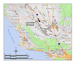
The Lost Hills Oil Field is a large oil field in the Lost Hills Range, north of the town of Lost Hills in western Kern County, California, in the United States.
Within the petroleum industry, proven crude oil reserves in the United States was 44.4 billion barrels (7.06×10⁹ m3) of crude oil as of the end of 2021, excluding the Strategic Petroleum Reserve.
Shale gas in the United States is an available source of unconventional natural gas. Led by new applications of hydraulic fracturing technology and horizontal drilling, development of new sources of shale gas has offset declines in production from conventional gas reservoirs, and has led to major increases in reserves of U.S. natural gas. Largely due to shale gas discoveries, estimated reserves of natural gas in the United States in 2008 were 35% higher than in 2006.
The Duvernay Formation is a stratigraphical unit of Frasnian age in the Western Canadian Sedimentary Basin.
The Utica Shale is a stratigraphical unit of Upper Ordovician age in the Appalachian Basin. It underlies much of the northeastern United States and adjacent parts of Canada.
The inclusion of unconventional shale gas with conventional gas reserves has caused a sharp increase in estimated recoverable natural gas in Canada. Until the 1990s success of hydraulic fracturing in the Barnett Shales of north Texas, shale gas was classed as "unconventional reserves" and was considered too expensive to recover. There are a number of prospective shale gas deposits in various stages of exploration and exploitation across the country, from British Columbia to Nova Scotia.
Tight oil is light crude oil contained in unconventional petroleum-bearing formations of low permeability, often shale or tight sandstone. Economic production from tight oil formations requires the same hydraulic fracturing and often uses the same horizontal well technology used in the production of shale gas. While sometimes called "shale oil", tight oil should not be confused with oil shale or shale oil. Therefore, the International Energy Agency recommends using the term "light tight oil" for oil produced from shales or other very low permeability formations, while the World Energy Resources 2013 report by the World Energy Council uses the terms "tight oil" and "shale-hosted oil".
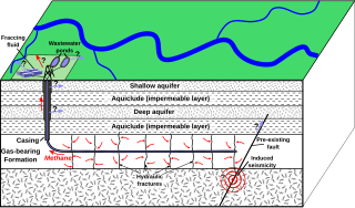
Fracking is a well stimulation technique involving the fracturing of formations in bedrock by a pressurized liquid. The process involves the high-pressure injection of "fracking fluid" into a wellbore to create cracks in the deep-rock formations through which natural gas, petroleum, and brine will flow more freely. When the hydraulic pressure is removed from the well, small grains of hydraulic fracturing proppants hold the fractures open.
Shale gas is an unconventional natural gas produced from shale, a type of sedimentary rock. Shale gas has become an increasingly important source of natural gas in the United States over the past decade, and interest has spread to potential gas shales in Canada, Europe, Asia, and Australia. One analyst expects shale gas to supply as much as half the natural gas production in North America by 2020.
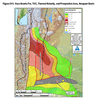
The Vaca Muerta Formation, commonly known as Vaca Muerta, is a geologic formation of Late Jurassic to Early Cretaceous age, located in the Neuquén Basin in northern Patagonia, Argentina. It is well known as the host rock for major deposits of shale oil and shale gas.
The Bazhenov Formation or Bazhenov Shale is a geological stratum in the West Siberian basin. It was formed from sediment deposited in a deep-water sea in Tithonian–early Berriasian time. The sea covered more than one million square kilometers in the central basin area. Highly organic-rich siliceous shales were deposited during this time in anoxic conditions on the sea bottom. The sea was connected to the world's oceans and contains trace minerals derived from dissolved minerals and organic materials similar to sapropel sediments in the Black Sea.
As of 2013 the Cline Shale, also referred to as the "Wolfcamp/Cline Shale", the "Lower Wolfcamp Shale", or the "Spraberry-Wolfcamp shale", or even the "Wolfberry", is a promising Pennsylvanian oil play east of Midland, Texas which underlies ten counties: Fisher, Nolan, Sterling, Coke, Glasscock, Tom Green, Howard, Mitchell, Borden and Scurry counties. Exploitation is projected to rely on hydraulic fracturing.
an organic rich shale, with Total Organic Content (TOC) of 1-8%, with silt and sand beds mixed in. It lies in a broad shelf, with minimal relief and has nice light oil of 38-42 gravity with excellent porosity of 6-12% in thickness varying 200 to 550 feet thick.
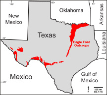
The Eagle Ford Group is a sedimentary rock formation deposited during the Cenomanian and Turonian ages of the Late Cretaceous over much of the modern-day state of Texas. The Eagle Ford is predominantly composed of organic matter-rich fossiliferous marine shales and marls with interbedded thin limestones. It derives its name from outcrops on the banks of the West Fork of the Trinity River near the old community of Eagle Ford, which is now a neighborhood within the city of Dallas. The Eagle Ford outcrop belt trends from the Oklahoma-Texas border southward to San Antonio, westward to the Rio Grande, Big Bend National Park, and the Quitman Mountains of West Texas. It also occurs in the subsurface of East Texas and South Texas, where it is the source rock for oil found in the Woodbine, Austin Chalk, and the Buda Limestone, and is produced unconventionally in South Texas and the "Eaglebine" play of East Texas. The Eagle Ford was one of the most actively drilled targets for unconventional oil and gas in the United States in 2010, but its output had dropped sharply by 2015. By the summer of 2016, Eagle Ford spending had dropped by two-thirds from $30 billion in 2014 to $10 billion, according to an analysis from the research firm Wood Mackenzie. This strike has been the hardest hit of any oil fields in the world. The spending was, however, expected to increase to $11.6 billion in 2017. A full recovery is not expected any time soon.
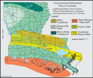
The Tuscaloosa Marine Shale is a 90-million-year-old Late Cretaceous sedimentary rock formation across the Gulf Coast region of the United States.
Fracking in Canada was first used in Alberta in 1953 to extract hydrocarbons from the giant Pembina oil field, the biggest conventional oil field in Alberta, which would have produced very little oil without fracturing. Since then, over 170,000 oil and gas wells have been fractured in Western Canada. Fracking is a process that stimulates natural gas or oil in wellbores to flow more easily by subjecting hydrocarbon reservoirs to pressure through the injection of fluids or gas at depth causing the rock to fracture or to widen existing cracks.
Unconventional reservoirs, or unconventional resources are accumulations where oil & gas phases are tightly bound to the rock fabric by strong capillary forces, requiring specialised measures for evaluation and extraction.
References
↑ M.N. Bramlette (1946). The Monterey Formation of California and the Origin of its Siliceous Rocks. USGS Professional Paper 212.
↑ CCST Releases Report on Well Stimulation Technologies, August 28, 2014. "The 2011 EIA report suggested 15-billion barrels of recoverable oil in these source rocks but a subsequent 2014 correction by EIA reduced the estimate to 0.6billion barrels. Recovering these resources would certainly require well stimulation. However, Berkeley Lab investigators found no reports of successful production from these deep source rocks and had questions about the EIA estimation methodology. The study's review of the two resource projections from deep source rocks in the Monterey Formation developed by EIA concluded that both these estimates are highly uncertain."
↑ Burnett, William C.; Stanley R. Riggs, eds. (1990-05-25). Phosphate Deposits of the World: Volume 3, Neogene to Modern Phosphorites (Cambridge Earth Science Series). Cambridge University Press. ISBN0-521-33370-9.
↑ Mero, W.E., Thurston, S.P., and Kropschot, R.E., 1992, The Point Arguello Field, In Giant Oil and Gas Fields of the Decade, 1978–1988, AAPG Memoir 54, Halbouty, M.T., editor, Tulsa: American Association of Petroleum Geologists, ISBN0891813330
This page is based on this Wikipedia article Text is available under the CC BY-SA 4.0 license; additional terms may apply. Images, videos and audio are available under their respective licenses.


