Elliott, Queensland

Last updated

Elliott
Bundaberg,  Queensland
Australia Queensland location map.svg
Red pog.svg
Elliott
Elliott, Queensland
Coordinates 25°00′17″S152°16′41″E / 25.0047°S 152.2780°E / -25.0047; 152.2780 (Elliott (centre of locality))
Population156 (2021 census) [1]
 • Density1.077/km2 (2.790/sq mi)
Postcode(s) 4670
Area144.8 km2 (55.9 sq mi)
Time zone AEST (UTC+10:00)
LGA(s) Bundaberg Region
State electorate(s) Burnett
Federal division(s) Hinkler
Suburbs around Elliott:
South Bingera Branyan
Kensington
Alloway
Pine Creek Elliott Kinkuna
Promisedland
Gregory River
North Gregory Goodwood

Elliott is a rural locality in the Bundaberg Region, Queensland, Australia. [2] In the 2021 census, Elliott had a population of 156 people. [1]

Contents

Geography

The locality is bounded in part by the Childers Road to the west and by Goodwood Road to the east. [3]

The Springs is a neighbourhood in the north of the locality ( 24°57′00″S152°16′00″E / 24.95°S 152.2666°E / -24.95; 152.2666 (The Springs) ) [4]

The Elliott River rises in the west of the locality ( 25°00′28″S152°12′51″E / 25.00787°S 152.21410°E / -25.00787; 152.21410 (Elliott River (source)) ) and flows east, forming part of the boundary with Alloway and exiting the locality. The river flows into the Coral Sea at Elliott Heads. [3]

Several large areas of the locality are within the Elliott River State Forest which extends into neighbouring Gregory River and Promisedland to the south-west. [3]

Other large areas are within the Bingera National Park and the Bingera Conservation Parks (1 and 2). [3] These parks seek to protect coastal plant communities, the waterholes along Mahogany Creek and an important habitat corridor. Although open to the public, the parks do not have visitor facilities as they are intended to be natural places and therefore only suitable for "self-reliant" visitors. [5]

The remainder of the locality is used for agriculture, mostly growing sugarcane with some grazing on native vegetation. There is a network of cane tramways in the locality to transport the harvested sugarcane to the Isis Central sugar mill. [3]

History

The locality is named after the Elliott River, which in turn is named after pastoralist and politician Gilbert Eliott (albeit with a slightly different spelling). [2]

Elliott State School opened on 4 February 1886 and it is believed there was a "school at Bingera and Baranyan Homestead near Bundaberg" on the site prior to this. In 1960, it was renamed Alloway State School. [6] It is now within the boundaries of the suburb of Alloway. [3]

The Bundaberg Soaring Club (now the Bundaberg Gliding Club) was established in 1965. [7]

The Bingera National Park was gazetted in 2006. The two Bingera Conservation Parks were gazette in 2010. [5]

Demographics

In the 2016 census, Elliott had a population of 138 people. [8]

In the 2021 census, Elliott had a population of 156 people. [1]

Education

Burnett Youth Learning Centre is a private secondary (7-12) school for boys and girls at 3693 Goodwood Road ( 25°00′27″S152°22′35″E / 25.0075°S 152.3763°E / -25.0075; 152.3763 (Burnett Youth Learning Centre) ). [9] [10] In 2018, the school had an enrolment of 49 students with 10 teachers (9 full-time equivalent) and 8 non-teaching staff (5 full-time equivalent). [11] Operating on a 28.3-hectare (70-acre) site (formerly used by , this Christian school provides individual programs for children who have disengaged from mainstream education, with a strong focus on developing vocational skills in farming, mechanical repairs, and hospitality. [10] [12] [13]

There are no government schools in Elliott. The nearest government primary school are Alloway State School in neighbouring Alloway to the north-west, Branyan Road State School to neighbouring Branyan to the north, Givelda State School in Givelda to the west. The nearest government secondary schools are Bundaberg State High School in Bundaberg Central and Isis District State High School in Childers to the south. [3]

Amenities

The Bundaberg Gliding Club operate their flights from an airfield off Childers Road in Bingera Conservation Park 1 in the west of the locality ( 25°03′03″S152°13′34″E / 25.0508°S 152.2260°E / -25.0508; 152.2260 (Bundaberg Gliding Club airfield) ). [3] [5] [7]

Related Research Articles

<span class="mw-page-title-main">Burnett Heads, Queensland</span> Town in Queensland, Australia

Burnett Heads is a coastal town and locality in the Bundaberg Region, Queensland, Australia. In the 2016 census, the locality of Burnett Heads had a population of 2,656 people.

<span class="mw-page-title-main">Elliott Heads, Queensland</span> Town in Queensland, Australia

Elliott Heads is a coastal town and locality in the Bundaberg Region, Queensland, Australia. In the 2021 census, the locality of Elliott Heads had a population of 1,160 people.

<span class="mw-page-title-main">Wallaville</span> Town in Queensland, Australia

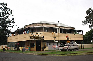
Wallaville is a rural town and locality in the Bundaberg Region, Queensland, Australia. It is 372 kilometres (231 mi) north of the state capital, Brisbane and 43 kilometres (27 mi) south west of the regional centre of Bundaberg. In the 2016 census, Wallaville had a population of 410 people.

<span class="mw-page-title-main">Moore Park Beach, Queensland</span> Town in Queensland, Australia

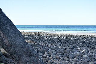
Moore Park Beach is a coastal rural locality in the Bundaberg Region, Queensland, Australia. The coastal town of Moore Park is within the locality.

The Shire of Woongarra was a local government area located to the south and east of the regional city of Bundaberg. The shire, administered from Bundaberg itself, covered an area of 722.4 square kilometres (278.9 sq mi), and existed as a local government entity from 1885 until 1994, when it amalgamated with Gooburrum to form the Shire of Burnett.

<span class="mw-page-title-main">South Kolan</span> Town in Queensland, Australia

South Kolan is a rural locality in the Bundaberg Region, Queensland, Australia. In the 2021 census, South Kolan had a population of 1,258 people.

Avoca is a south-western suburb of Bundaberg in the Bundaberg Region, Queensland, Australia. In the 2021 census, Avoca had a population of 4,912 people.

South Bingera is a rural residential locality in the Bundaberg Region, Queensland, Australia. In the 2016 census South Bingera had a population of 661 people.

Oakwood is a rural locality in the Bundaberg Region, Queensland, Australia. In the 2016 census, Oakwood had a population of 331 people.

<span class="mw-page-title-main">Mon Repos, Queensland</span> Suburb of Bundaberg, Queensland, Australia

Mon Repos is a coastal locality in the Bundaberg Region, Queensland, Australia. In the 2016 census Mon Repos had a population of 30 people.

Sharon is a rural locality in the Bundaberg Region, Queensland, Australia. In the 2016 census, Sharon had a population of 1,316 people.

<span class="mw-page-title-main">Alloway, Queensland</span> Suburb of Bundaberg Region, Queensland, Australia

Alloway is a rural locality in the Bundaberg Region, Queensland, Australia. In the 2021 census, Alloway had a population of 488 people.

Branyan is a rural locality in the Bundaberg Region, Queensland, Australia. In the 2021 census, Branyan had a population of 4,660 people.

<span class="mw-page-title-main">Branyan Road State School</span> Historic site in Queensland, Australia

Branyan Road State School is a heritage-listed state school at Branyan Drive, Branyan, Bundaberg, Bundaberg Region, Queensland, Australia. It was designed by Queensland Department of Public Works and built in 1905. It was added to the Queensland Heritage Register on 1 May 2015.

Givelda is a rural locality in the Bundaberg Region, Queensland, Australia. In the 2021 census, Givelda had a population of 42 people.

Kinkuna is a coastal locality in the Bundaberg Region, Queensland, Australia. In the 2021 census, Kinkuna had a population of 105 people.

Electra is a rural locality in the Bundaberg Region, Queensland, Australia. In the 2021 census, Electra had a population of 103 people.

<span class="mw-page-title-main">Fairymead, Queensland</span> Suburb of Bundaberg Region, Queensland, Australia

Fairymead is a coastal locality in the Bundaberg Region, Queensland, Australia. In the 2021 census, Fairymead had a population of 28 people.

Pine Creek is a rural locality in the Bundaberg Region, Queensland, Australia. In the 2016 census Pine Creek had a population of 254 people.

Duingal is a locality in the Bundaberg Region, Queensland, Australia. In the 2021 census, Duingal had a population of 70 people.

References

  1. 1 2 3 Australian Bureau of Statistics (28 June 2022). "Elliott (SAL)". 2021 Census QuickStats. Retrieved 28 February 2023. OOjs UI icon edit-ltr-progressive.svg
  2. 1 2 "Elliott – locality in Bundaberg Region (entry 48971)". Queensland Place Names. Queensland Government . Retrieved 18 September 2020.
  3. 1 2 3 4 5 6 7 8 "Queensland Globe". State of Queensland . Retrieved 27 October 2020.
  4. "The Springs – locality unbounded in Bundaberg Regional (entry 34135)". Queensland Place Names. Queensland Government . Retrieved 18 September 2020.
  5. 1 2 3 "Bingera National Park, Bingera Conservation Park 1 and Bingera Conservation Park 2 Management Statement 2013" (PDF). Queensland Government. Archived (PDF) from the original on 27 October 2020. Retrieved 28 October 2020.
  6. Queensland Family History Society (2010), Queensland schools past and present (Version 1.01 ed.), Queensland Family History Society, ISBN   978-1-921171-26-0
  7. 1 2 "Bundaberg Gliding Club - Learn to Fly or Experience Free Flight in our Gliders". www.gliding.inbundy.com.au. Retrieved 27 October 2020.
  8. Australian Bureau of Statistics (27 June 2017). "Elliott (SSC)". 2016 Census QuickStats. Retrieved 20 October 2018. OOjs UI icon edit-ltr-progressive.svg
  9. "State and non-state school details". Queensland Government. 9 July 2018. Archived from the original on 21 November 2018. Retrieved 21 November 2018.
  10. 1 2 "Burnett Youth Learning Centre" . Retrieved 28 October 2020.
  11. "ACARA School Profile 2018". Australian Curriculum, Assessment and Reporting Authority . Retrieved 28 January 2020.
  12. "WHAT DO WE OFFER?". BYLC. Retrieved 27 October 2020.
  13. Walmsley, Ash (14 September 2014). "Tractors to train Burnett youth". Farm Online. Retrieved 27 October 2020.

Further reading