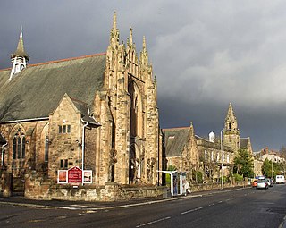
Glasgow City Council is the local government authority for Glasgow City council area, Scotland. In its modern form it was created in 1996. Glasgow was formerly governed by a corporation, also known as the town council, from the granting of its first burgh charter in the 1170s until 1975. From 1975 until 1996 the city was governed by City of Glasgow District Council, a lower-tier authority within the Strathclyde region.

Rutherglen is a town in South Lanarkshire, Scotland, immediately south-east of the city of Glasgow, three miles from its centre and directly south of the River Clyde. Having previously existed as a separate Lanarkshire burgh, in 1975 Rutherglen lost its own local council and administratively became a component of the City of Glasgow District within the Strathclyde region. In 1996 the towns were reallocated to the South Lanarkshire council area.

Cathcart is an area of Glasgow between Battlefield, Mount Florida, King's Park, Muirend and Newlands. The White Cart Water flows through Cathcart, downstream from Linn Park. In 2014, it was rated one of the most attractive postcode areas to live in Scotland.

Castlemilk is a district of Glasgow, Scotland. It lies to the far south of the city centre, adjacent to the Croftfoot and Simshill residential areas within the city to the north-west, the town of Rutherglen - neighbourhoods of Spittal to the north-east and Fernhill to the east, Linn Park and its golf course to the west, and the separate village of Carmunnock further south across countryside.

Carmunnock is a conservation village situated within the Glasgow City council area, lying within three miles of East Kilbride and Rutherglen in South Lanarkshire and Busby in East Renfrewshire. The nearest other district within Glasgow is Castlemilk.

Glasgow South is a burgh constituency of the House of Commons of the Parliament of the United Kingdom (Westminster). It elects one Member of Parliament (MP) by the first past the post system of election.

Toryglen is a district in southern Glasgow, Scotland, falling within the Langside ward under Glasgow City Council. It is approximately two miles south of the city centre, bounded to the west by Mount Florida, the north-west by Polmadie, to the north-east by the West Coast Main Line railway and the M74 motorway the south by King's Park, and immediately to the east by the town of Rutherglen.
Mount Florida is an area in the south-east of the city of Glasgow, Scotland.

Fernhill is a residential neighbourhood in the Scottish town of Rutherglen in South Lanarkshire; it is situated south of the River Clyde and borders the Rutherglen neighbourhoods of High Burnside to the north and Cathkin to the east, the Glasgow district of Castlemilk to the west, and the open lands of Fernbrae Meadows to the south. Its location on a steep incline which is part of the Cathkin Braes range of hills offers panoramic views over the south and eastern parts of Greater Glasgow.

Simshill is an area of Glasgow, Scotland. It is on the South Side of the city, approximately 3.7 miles (6.0 km) south of the city centre. Adjacent areas are Cathcart, King's Park, Croftfoot and Castlemilk. Linn Park is to the south-west of Simshill.

The A728 is a route number in Glasgow, Scotland applied to two connected roads.

King's Park is a district in the city of Glasgow, Scotland. It is situated south of the River Clyde and borders the Glasgow areas of Croftfoot, Cathcart, Simshill, Mount Florida and Toryglen and the neighbourhood of Bankhead in the adjoining town of Rutherglen.

Croftfoot railway station is a railway station in South Lanarkshire that lies close to the Glasgow City council area / South Lanarkshire boundary serving the Croftfoot area of the City of Glasgow and the Spittal and Bankhead areas of the town of Rutherglen, Scotland. The station is managed by ScotRail and is on the Newton branch of the Cathcart Circle Line.

Burnside is a mostly residential area in the town of Rutherglen in South Lanarkshire, Scotland. Including the neighbourhoods of High Burnside and High Crosshill, respectively south and north-west of its main street, it borders Overtoun Park in Rutherglen plus several other residential areas of the town, as well as western parts of neighbouring Cambuslang.

The A730 road in Scotland runs between the centre of Glasgow and the south-eastern edge of the city's urban area at Cathkin.

Linn Park is an 82-hectare (200-acre) park in Glasgow, Scotland, surrounded by the suburbs of Cathcart, Muirend, Simshill, and Castlemilk, also bordering Netherlee in East Renfrewshire. It is Glasgow's third largest park, after Pollok Country Park and Dams to Darnley Country Park, although Dams to Darnley is half in East Renfrewshire. Both Linn and Pollok parks have the White Cart Water flowing through them. Some areas in the park are unsuitable for prams and the infirm.

Clarkston is a suburban town in East Renfrewshire, in the Central Lowlands of Scotland. A dormitory town with a population of around 10,000, Clarkston is on the southern fringe of the Greater Glasgow conurbation and directly adjoins the neighbouring suburban villages of Busby and Netherlee, as well as the towns of Newton Mearns and Giffnock.

Linn is one of the 23 wards of Glasgow City Council. There are 4 councillors for the area; as of 19 November 2022, it is represented by the Scottish National Party and Scottish Labour, who have two councillors each.

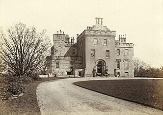
Castlemilk House was a country house located in what is now the Castlemilk district of Glasgow, Scotland. The house was the ancestral home of the Stirling-Stuart family and was built around the 15th-century Cassiltoun Tower during the 18th and 19th centuries. The house and Castlemilk Estate were purchased by Glasgow Corporation in 1938, with the house serving as a children's home until it was closed in 1969 and demolished in 1972.


