
An intersection or an at-grade junction is a junction where two or more roads converge, diverge, meet or cross at the same height, as opposed to an interchange, which uses bridges or tunnels to separate different roads. Major intersections are often delineated by gores and may be classified by road segments, traffic controls and lane design.

A Michigan left or P-turn is an at-grade intersection design that replaces each left (farside) turn at an intersection between a (major) divided roadway and a secondary (minor) roadway with the combination of a right (nearside) turn followed by a U-turn, or a U-turn followed by a right (nearside) turn, depending on the situation. It is in use in numerous countries.

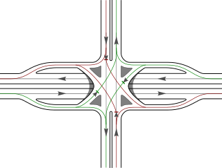
A cloverleaf interchange is a two-level interchange in which all turns are handled by slip roads. To go left, vehicles first continue as one road passes over or under the other, then exit right onto a one-way three-fourths loop ramp (270°) and merge onto the intersecting road. The objective of a cloverleaf is to allow two highways to cross without the need for any traffic to be stopped by traffic lights. The limiting factor in the capacity of a cloverleaf interchange is traffic weaving.

A diamond interchange is a common type of road junction, used where a controlled-access highway crosses a minor road.
A single-point urban interchange, also called a single-point interchange (SPI) or single-point diamond interchange (SPDI), is a type of highway interchange. The design was created in order to help move large volumes of traffic through limited amounts of space efficiently.
A partial cloverleaf interchange or parclo is a modification of a cloverleaf interchange.
A jughandle is a type of ramp or slip road that changes the way traffic turns left at an at-grade intersection. Instead of a standard left turn being made from the left lane, left-turning traffic uses a ramp on the right side of the road. In a standard forward jughandle or near-side jughandle, the ramp leaves before the intersection, and left-turning traffic turns left off of it rather than the through road; right turns are also made using the jughandle. In a reverse jughandle or far-side jughandle, the ramp leaves after the intersection, and left-turning traffic loops around to the right and merges with the crossroad before the intersection.

A superstreet, also known as a restricted crossing U-turn (RCUT), J-turn, or reduced conflict intersection (RCI), is a type of road intersection that is a variation of the Michigan left. In this configuration, in contrast to the Michigan left, traffic on the minor road is not permitted to proceed straight across the major road or highway. Drivers on the minor road wishing to turn left or go straight must turn right onto the major road, then, a short distance away, queue (wait) into a designated U-turn lane in the median. When traffic clears, they complete the U-turn and then either go straight or make a right turn when they intersect the other half of the minor road.
State Route 154 (SR-154) or Bangerter Highway is a partial expressway running west and then north from Draper through western Salt Lake County, eventually reaching the Salt Lake City International Airport in Salt Lake City. Construction began in 1988 after planning for the highway began more than two decades prior. For the next ten years, portions of the highway opened as constructed, with the entire route finished by 1998.

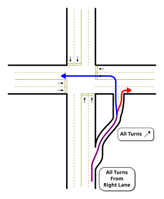
A diverging diamond interchange (DDI), also called a double crossover diamond interchange (DCD), is a subset of diamond interchange in which the opposing directions of travel on the non-freeway road cross each other on either side of the interchange so that traffic crossing the freeway on the overpass or underpass is operating on the opposite driving side from that which is customary for the jurisdiction. The crossovers may employ one-side overpasses or be at-grade and controlled by traffic lights.
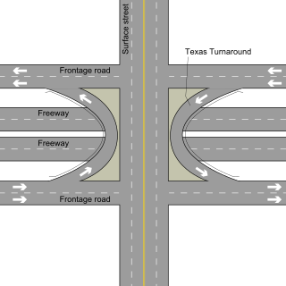
A Texas U-turn, or Texas turnaround, boomerang, or loop around, is a lane allowing cars traveling on one side of a one-way frontage road to U-turn onto the opposite frontage road. Typically controlled by yield signs, these allow U-turning traffic to bypass two traffic signals and avoid crossing the local traffic twice.
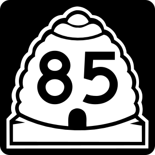
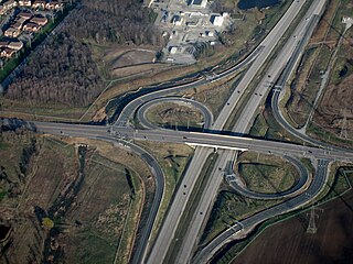
The Mountain View Corridor is a freeway under construction in northern Utah that will run along the western periphery of Salt Lake County and south into northwest Utah County. Except for the last several miles on its southern end the Mountain View Corridor is numerically designated as State Route 85 (SR-85) in the Utah state highway system. The entire Mountain View Corridor will be maintained by the Utah Department of Transportation (UDOT).
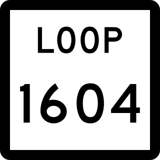
Loop 1604 is the outer highway loop encircling San Antonio, Texas, spanning approximately 95.6 miles (153.9 km). Originally constructed as a two-lane highway, the northern segment of the route, from US 90 in western San Antonio to Kitty Hawk Road in northeastern Bexar County, has been upgraded to a four-lane freeway. Loop 1604 is designated the Charles W. Anderson Loop in honor of former Bexar County Judge Charles W. Anderson, who died from cancer in 1964 after serving for 25 years.
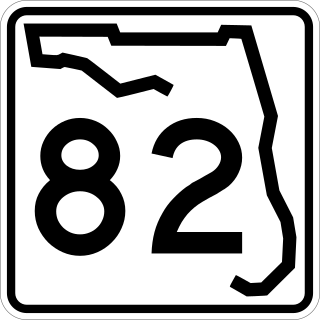
State Road 82 is a 29-mile-long east–west highway serving northern Lee and Collier County, Florida. The western terminus is an intersection with Cleveland Avenue in Fort Myers; the eastern terminus is an intersection with SR 29 midway between Immokalee and Felda.
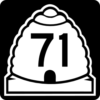
State Route 71 (SR-71) is a state highway completely within the Salt Lake City metropolitan area in the northern portion of the US state of Utah. It runs from SR-154 in the southwest side of the city to SR-186 in Downtown Salt Lake City. The route spans 22.47 miles (36.16 km) as it runs along portions of 12600 South, 12300 South, 900 East, and 700 East streets.
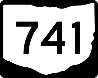
State Route 741 is a north–south state highway in the southwest portion of the U.S. state of Ohio. The southern terminus of the route is at a diamond interchange with I-71 at its Exit 25 near Kings Mills, adjacent to the Kings Island Amusement Park. State Route 741’s northern terminus is at a partial interchange with I-75 at its Exit 50B in Moraine, just south of Dayton.
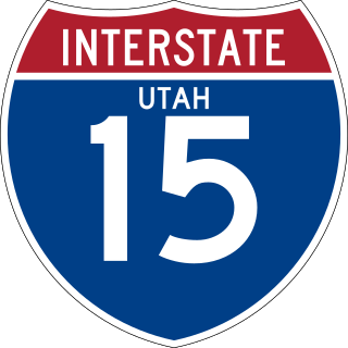
Interstate 15 (I-15) runs north–south in the U.S. state of Utah through the southwestern and central portions of the state, passing through most of the state's population centers, including St. George and those comprising the Wasatch Front: Provo–Orem, Salt Lake City, and Ogden–Clearfield. It is Utah's primary and only north–south interstate highway, as the vast majority of the state's population lives along its corridor; the Logan metropolitan area is the state's only Metropolitan Statistical Area through which I-15 does not pass. In 1998, the Utah State Legislature designated Utah's entire portion of the road as the Veterans Memorial Highway.

State Route 173 is a major east–west thoroughfare completely within Salt Lake County in northern Utah. From its western terminus at SR-111 it passes through the growing west side of Salt Lake County, eventually reaching US-89 in Murray.

Interstate business routes are roads connecting a central or commercial district of a city or town with an Interstate bypass. These roads typically follow along local streets often along a former U.S. Route or state highway that had been replaced by an Interstate. Interstate business route reassurance markers are signed as either loops or spurs using a green shield shaped and numbered like the shield of the parent Interstate highway.
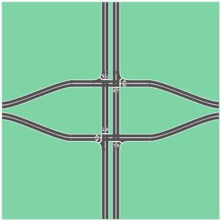
A split intersection is a rarely built at-grade variant of the diamond interchange. Compared to a conventional four-leg intersection or road crossing, the arterial road is split into separate carriageways by 200 to 300 feet, allowing a queue of left turning vehicles behind a completed turn into the crossroad without any conflict to oncoming traffic. On the crossroad, the four leg intersection is being replaced by two intersections. The beginning one-way traffic at the fourth leg makes the intersections reduce the number of conflicts similar to a three leg T-intersection to improve traffic flow.


