Berkey, Ohio | |
---|---|
![]() Village Hall | |
![]() Location in Lucas County and the state of Ohio. | |
Coordinates: 41°42′30″N83°50′18″W / 41.70833°N 83.83833°W | |
Country | United States |
State | Ohio |
County | Lucas |
Area | |
• Total | 4.24 sq mi (10.98 km2) |
• Land | 4.24 sq mi (10.98 km2) |
• Water | 0.00 sq mi (0.00 km2) |
Elevation | 702 ft (214 m) |
Population (2020) | |
• Total | 275 |
• Estimate (2023) [3] | 284 |
• Density | 64.87/sq mi (25.05/km2) |
Time zone | UTC-5 (Eastern (EST)) |
• Summer (DST) | UTC-4 (EDT) |
ZIP code | 43504 |
Area code | 419 |
FIPS code | 39-05732 [4] |
GNIS feature ID | 2398102 [2] |
Website | www |
Berkey is a village in Lucas County, Ohio, United States. The population was 275 at the 2020 census.
Berkey was originally called Riga. [5] The present name is derived from Richard K. Berkeybile, an early postmaster. [5] A post office called Riga was established in 1837, and the name was changed to Berkey in 1870. [6]
According to the United States Census Bureau, the village has a total area of 4.18 square miles (10.83 km2), all land. [7]
Census | Pop. | Note | %± |
---|---|---|---|
1920 | 201 | — | |
1930 | 261 | 29.9% | |
1940 | 248 | −5.0% | |
1950 | 239 | −3.6% | |
1960 | 257 | 7.5% | |
1970 | 294 | 14.4% | |
1980 | 306 | 4.1% | |
1990 | 264 | −13.7% | |
2000 | 265 | 0.4% | |
2010 | 237 | −10.6% | |
2020 | 275 | 16.0% | |
2023 (est.) | 284 | [3] | 3.3% |
U.S. Decennial Census [8] |
At the 2010 census there were 237 people, 99 households, and 73 families living in the village. The population density was 56.7 inhabitants per square mile (21.9/km2). There were 112 housing units at an average density of 26.8 per square mile (10.3/km2). The racial makeup of the village was 99.2% White and 0.8% Asian. Hispanic or Latino of any race were 1.3%. [9]
Of the 99 households 28.3% had children under the age of 18 living with them, 63.6% were married couples living together, 9.1% had a female householder with no husband present, 1.0% had a male householder with no wife present, and 26.3% were non-families. 22.2% of households were one person and 11.2% were one person aged 65 or older. The average household size was 2.39 and the average family size was 2.77.
The median age in the village was 48.2 years. 21.1% of residents were under the age of 18; 5% were between the ages of 18 and 24; 18.6% were from 25 to 44; 37.2% were from 45 to 64; and 18.1% were 65 or older. The gender makeup of the village was 51.1% male and 48.9% female.
At the 2000 census there were 265 people, 98 households, and 81 families living in the village. The population density was 63.5 inhabitants per square mile (24.5/km2). There were 100 housing units at an average density of 23.9 per square mile (9.2/km2). The racial makeup of the village was 98.11% White, 0.75% Native American, 0.38% Asian, and 0.75% from two or more races. Hispanic or Latino of any race were 0.38%. [4]
Of the 98 households 39.8% had children under the age of 18 living with them, 69.4% were married couples living together, 10.2% had a female householder with no husband present, and 17.3% were non-families. 15.3% of households were one person and 8.2% were one person aged 65 or older. The average household size was 2.70 and the average family size was 3.04.
The age distribution was 29.4% under the age of 18, 3.8% from 18 to 24, 30.2% from 25 to 44, 25.3% from 45 to 64, and 11.3% 65 or older. The median age was 37 years. For every 100 females there were 90.6 males. For every 100 females age 18 and over, there were 94.8 males.
The median household income was $60,500 and the median family income was $65,313. Males had a median income of $46,000 versus $31,875 for females. The per capita income for the village was $25,944. None of the population or families were below the poverty line.
Country Life Acres is a village in St. Louis County, Missouri, United States. The population was 72 at the 2020 census.
Westwood is a village in west St. Louis County, Missouri, United States. The population was 316 at the 2020 census.
Wilbur Park is a village in St. Louis County, Missouri, United States. The population was 439 at the 2020 census.
Champ is a village in St. Louis County, Missouri, United States. The population was 10 at the 2020 census.
Hanley Hills is a village in St. Louis County, Missouri, United States. The population was 2,101 at the 2010 census.
Edgeley is a city in LaMoure County, North Dakota, United States. The population was 585 at the 2020 census.
Melrose is a village in Paulding County, Ohio, United States. The population was 233 at the 2020 census.
Darbyville is a village in Pickaway County, Ohio, United States. The population was 186 at the 2020 census.
Beech Bottom is a village in Brooke County, West Virginia, United States, situated along the Ohio River. The population was 523 at the 2010 census. It is part of the Weirton–Steubenville metropolitan area.
Windsor Heights is a village in Brooke County, West Virginia, United States. It is part of the Wheeling, West Virginia Metropolitan Statistical Area. The population was 423 at the 2010 census. Grace Davis was the mayor as of June 2017.
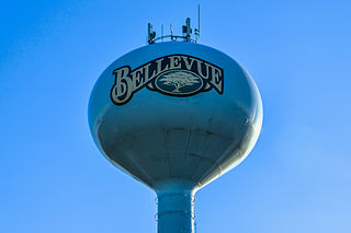
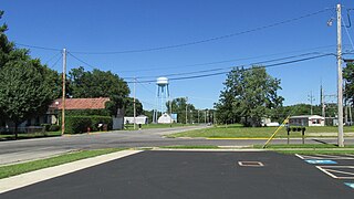
Bellevue is a village in Brown County, Wisconsin. It was a town until incorporating as a village on February 14, 2003. The population was 15,935 at the time of the 2020 census. Bellevue is part of the Green Bay metropolitan area. Bellevue sits around 4.34 miles (6.99 km) east from central Green Bay.
Friesland is a village in Columbia County, Wisconsin, United States. The population was 320 at the 2020 census. It is part of the Madison Metropolitan Statistical Area, and was named after Friesland, one of the twelve provinces of the Netherlands.
Kekoskee is a village in Dodge County, Wisconsin, United States. The population was 161 at the 2010 census.
Wilson is a village in Belmont and Monroe counties in the U.S. state of Ohio. The population was 129 at the 2020 census. It is part of the Wheeling metropolitan area.
Verona is a village in Montgomery and Preble counties in the U.S. state of Ohio. The population was 403 at the 2020 census. It is part of the Dayton Metropolitan Statistical Area.
Dorchester is a village in Clark and Marathon counties in the U.S. state of Wisconsin, along the 45th parallel. It is part of the Wausau, Wisconsin Metropolitan Statistical Area. The population was 876 at the 2010 census. Of this, 871 were in Clark County, and only 5 were in Marathon County.
Dallas is a village in Barron County in the U.S. state of Wisconsin. The population was 409 at the 2010 census. The village is located within the Town of Dallas.
Lowell is a village in Dodge County, Wisconsin, United States, along the Beaver Dam River. The population was 340 at the 2010 census. The village is located within the Town of Lowell.
Bloomington is a village in Grant County, Wisconsin, United States. The population was 735 as of the 2010 census. The village is located within the Town of Bloomington.
Monroe is a town in Green County, Wisconsin, United States. The population was 10,142 at the 2000 census. The City of Monroe is located partially within the town. The unincorporated community of Stearns is also located in the town.