WO2017020273A1 - Method and device for positioning and method of generating a positioning database in multicarrier network - Google Patents
Method and device for positioning and method of generating a positioning database in multicarrier network Download PDFInfo
- Publication number
- WO2017020273A1 WO2017020273A1 PCT/CN2015/086107 CN2015086107W WO2017020273A1 WO 2017020273 A1 WO2017020273 A1 WO 2017020273A1 CN 2015086107 W CN2015086107 W CN 2015086107W WO 2017020273 A1 WO2017020273 A1 WO 2017020273A1
- Authority
- WO
- WIPO (PCT)
- Prior art keywords
- positioning
- cell
- database
- measurement report
- cells
- Prior art date
Links
Images


Classifications
-
- H—ELECTRICITY
- H04—ELECTRIC COMMUNICATION TECHNIQUE
- H04W—WIRELESS COMMUNICATION NETWORKS
- H04W64/00—Locating users or terminals or network equipment for network management purposes, e.g. mobility management
-
- G—PHYSICS
- G01—MEASURING; TESTING
- G01S—RADIO DIRECTION-FINDING; RADIO NAVIGATION; DETERMINING DISTANCE OR VELOCITY BY USE OF RADIO WAVES; LOCATING OR PRESENCE-DETECTING BY USE OF THE REFLECTION OR RERADIATION OF RADIO WAVES; ANALOGOUS ARRANGEMENTS USING OTHER WAVES
- G01S5/00—Position-fixing by co-ordinating two or more direction or position line determinations; Position-fixing by co-ordinating two or more distance determinations
- G01S5/02—Position-fixing by co-ordinating two or more direction or position line determinations; Position-fixing by co-ordinating two or more distance determinations using radio waves
- G01S5/0252—Radio frequency fingerprinting
- G01S5/02521—Radio frequency fingerprinting using a radio-map
- G01S5/02524—Creating or updating the radio-map
Definitions
- the present disclosure generally relates to the technical field of positioning, and particularly, to a method of generating a positioning database and a positioning method and device based on the database in multicarrier network.
- Trilateration is determining the position of a mobile device by measuring distances to base stations with known positions.
- Triangulation determines the position of a mobile device by position inference based on measured angles to base stations.
- both of the methods are highly sensitive to errors caused by signal attenuation, refection, and scattering.
- An alternative approach is to firstly create a positioning database of reference measurement reports for received signal strengths.
- Reference measurement reports are decided based on those measurements which are made from different locations by a test device.
- the reference measurement reports contain signal information, such as received signal strengths, from the hearable cells including serving cell and neighboring cell (s) .
- s serving cell and neighboring cell
- the database comparison can be based on the least mean square (LMS) approach.
- LMS least mean square
- x is number of cells which can be found both in the positioning request and the positioning database
- f i is the signal strength of the positioning request on the i th cell
- gi ( n) is the signal strength of the n th reference measurement report on the same cell
- y is number of hearable cells which is included in the positioning request while can’t be found in the positioning database
- f j is the signal strength on the j th cell in the positioning request
- l max is an estimated constant representing missing signal level value
- z is number of cells included in the n th reference measurement report but not included in the positioning request.
- FIG. 1 is an example of typical UMTS multicarrier deployment of a NodeB (in single-carrier network deployment it is called base station) .
- the NodeB supports 3 sectors each of which has 4 carriers. Therefore, there are 12 cells being supported by the NodeB in total.
- an object of the present disclosure is to introduce an efficient positioning approach in a multicarrier network system.
- a method of generating a database for positioning in a multi-carrier communication system comprises:
- creating a cell database in which cells are grouped by similar propagation characteristics comprises at least one of the following:
- creating a database of reference measurement reports of the different grids comprises:
- a method of positioning a mobile device in a multi-carrier communication system is also provided in the disclosure.
- the method comprises:
- comparing measurement report indicated in the positioning request with the positioning database further comprises:
- a positioning node for positioning a mobile device in a multi-carrier communication system is also provided in the disclosure.
- the positioning node comprises:
- -a receiving unit configured to receive a request of positioning the mobile device
- comparing unit configured to compare a measurement report indicated in the positioning request with a positioning database, wherein the positioning database includes reference measurement reports in different grids;
- -a selecting unit configured to select a plurality of grids in the positioning database according to the result from the comparing unit
- -an estimating unit configured to estimate the position of the mobile device based on the positions of the selected plurality of grids.
- the comparing unit comprises a pre-positioning unit configured to choose reference measurement reports which involve cells being within a same cell group as at least one cell involved in the measurement report in the positioning request, so that the number of reference measurement reports in the positioning database to be compared with the measurement report in the positioning request can be limited. Thus the calculation amount and complexity can be greatly decreased.
- an efficient positioning approach in a multicarrier network system is provided.
- a multicarrier network system there is no need to collect measurement report on every carrier when generate a positioning database.
- effort and cost for the collection can be greatly decreased.
- Method of positioning a mobile device in a multi-carrier communication system utilizing the positioning database can also be more efficient without loss of positioning error, since comparing measurement report in the positioning request with the reference measurement reports in the positioning database is more efficient.
- Fig. 1 is a model of multicarrier deployment of a NodeB
- Fig. 2a illustrates an example of procedure of generating a positioning database in multicarrier system
- Fig. 2b illustrates detailed steps for generating a reference measurement report of a grid
- Fig. 3 illustrates an example of procedure of positioning a mobile device using positioning database as provided in the disclosure
- Fig. 4 illustrates simulation result of positioning deviation with different carriers
- Fig. 5 is a block structure of a positioning node embodiment.
- the technology can additionally be considered to be embodied entirely within any form of computer-readable memory, including non-transitory embodiments such as solid-state memory, magnetic disk, or optical disk containing an appropriate set of computer instructions that would cause a processor to carry out the techniques described herein.
- Hardware implementations of the presently disclosed techniques may include or encompass, without limitation, digital signal processor (DSP) hardware, a reduced instruction set processor, hardware (e.g., digital or analog) circuitry including but not limited to application specific integrated circuit (s) (ASIC) and/or field programmable gate array (s) (FPGA (s) ) , and (where appropriate) state machines capable of performing such functions.
- DSP digital signal processor
- ASIC application specific integrated circuit
- FPGA field programmable gate array
- a computer is generally understood to comprise one or more processors or one or more controllers, and the terms computer, processor, and controller may be employed interchangeably.
- the functions may be provided by a single dedicated computer or processor or controller, by a single shared computer or processor or controller, or by a plurality of individual computers or processors or controllers, some of which may be shared or distributed.
- the term “processor” or “controller” also refers to other hardware capable of performing such functions and/or executing software, such as the example hardware recited above.
- the term “mobile device” refers to any terminal having wireless communication capabilities that may needs positioning for its ground truth, including but not limited to, mobile phones, cellular phones, smart phones, or tablets, portable computers, image capture devices such as digital cameras, gaming devices, and any portable units or terminals that have wireless communication capabilities, or Internet appliances permitting wireless Internet access and browsing and the like.
- the term “base station” (BS) may be referred to as may represent a node B (NodeB or NB) , an evolved NodeB (eNodeB or eNB) , arelay, a low power node such as a femto, a pico, that serves one or more cells.
- an embodiment of generating a database for positioning in a multicarrier system is provided as:
- step 201 for creating a cell database cells with similar propagation characteristics are grouped together. For example, cells transmitted on a same antenna have stable path loss relations.
- the macrocell pathloss is based on the modified COST231 Hata urban propagation model:
- h bs is the BS antenna height in meters
- h ms the antenna height of mobile device in meters
- f c the carrier frequency in MHz
- d is the distance between the BS and mobile device in meters
- the coefficients, e.g. 44.9, 6.55, 35.46, 13.82, utilized in this equation are uncertain because of varied topography, buildings. Signal refection and scattering also impact the equation a lot. The pathloss accuracy calculated by this equation is very poor in the urban and suburban area. Therefore, the proposed model is not frequently used for pathloss calculation.
- the coefficients may vary between different cells, they wound have no influence on the path loss between the mobile device and the cells if the cells are transmitted on one antenna.
- cells transmitted in a same sector have similar propagation characteristics thus can be labeled in one group.
- some cells in a sector are transmitted on one antenna; some in the same sector are transmitted on a different antenna.
- these cells have the similar propagation characteristics, thus can be labeled in one group.
- Fig. 4 illustrates simulation result of Cumulative Distribution Function (CDF) of positioning error with different carriers.
- CDF Cumulative Distribution Function
- measurement report which the measurement is taken at one location is only on a single carrier.
- a test device at location A obtains a measurement report on carrier 1.
- the measurement report on carrier 1 includes path loss of its serving cell and its neighboring cell (s) , as well as its ground truth. There is no need for the test device to obtain another measurement report on carrier 2 at the same location (location A) .
- carrier 2 is referring to a different cell from carrier 1, since they belong to a same cell group, a measurement report on any of carrier 1 or carrier 2 is needed for database collection.
- the test device After moving to location B, the test device obtains a measurement report on any of carrier 1 or carrier 2. For simplifying the collection of measurement reports taken at various locations, it is recommended that measurement reports taken within coverage of a same cell group are taken on a same carrier. For example, when location A and location B are within coverage of a same cell group, measurement report taken on carrier 1 is sent from the test device.
- step 203 in order for the accuracy of positioning, geographic area is segmented into different grids with smaller coverage than a cell. Practically, it is divided into equally sized squares and coverage of a square is less than 10m*10m. To reduce the size of a grid would to some extent increase the accuracy of positioning while the size of the positioning database would also be increased. Therefore, grid size for example between 4m*4m and 10m*10m need to balance between accuracy and size of the positioning database. What’s more, grid size in suburban area could be larger than that in urban area. It is noted that segmenting into grids has no specific sequence between cell grouping and measurement reports receiving.
- step 204 a database of reference measurement reports of the different grids in which corresponding grid locations are included is created.
- Fig. 2b can be referred to, wherein reference measurement report of a grid is obtained by:
- a reference measurement report of the grid is generated, made up of the reference received signal strength for each of the different cells as well as the grid location.
- reference measurement reports of the different grids make up the positioning database.
- ground truth of center point of a grid is reckoned as the grid location.Measurements taken within the coverage of a grid is collected to form reference measurement report of the corresponding grid. If there are two or more measurement reports received which the measuring locations are within a same grid, the received signal strengths will be sorted by different cells, and then reference signal strength for each of the different cells will be obtained. If measurement reports taken within coverage of a same cell group are taken on a same carrier in step 202, in most circumstances, serving cells of respective measurement reports are the same because of the size of the grid being much smaller than the cell. Then the received signal strength of the serving cell would be obtained by averaging those from respective measurement reports. Likewise, received signal strength from each of the neighboring cells in those measurement reports would also be obtained.
- serving cell of the reference measurement report of the grid would be the cell which is more times a serving cell of the respective measurement report. For example, there are 3 measurement reports in a grid, and Cell A is the serving cell of 2 measurement reports while Cell B is the serving cell of the other report. Cell A would be the serving cell in the grid. In another example, there are 2 measurement reports in a grid with different serving cells Cell A and Cell B. Either of these cells would be the serving cell of the reference measurement report. It is also possible a scheme that two serving cells are involved in a same reference measurement report.
- multiple serving cells may occur in a reference measurement report of the grid, multiple strongest neighboring cells may also occur in the reference measurement report of the grid.
- the reference measurement report of the grid includes received signal strength of the serving cell and each of the neighboring cells.
- location A has three neighboring cells X, Y and Z
- location B which is within a same grid has three neighboring cells X, Y and W
- received signal strengths of cell X and Y would be averaged as the reference received signal strengths, together with the received signal strengths of cell Z and W.
- Reference measurement report of the grid includes received signal strength of a serving cell and 4 neighboring cells X, Y, Z and W, as well as the location of the center point of the grid.
- database of reference measurement reports of the different grids is created.
- the database is built offline based on received measurement reports from a test device. Utilizing propagation model mentioned above and pathloss difference caused by frequency, effort and cost for off line measurement reports collection can be greatly decreased in multicarrier communication system. Furthermore, the size of hardware disk for the positioning database is also decreased.
- the positioning database is created online through online data collection which means the measurement reports are sent from different communicating user terminals.
- live network request radio measurement from GSM/CDMA/UMTS/LTE/WLAN for a user terminal which performs high accuracy positioning such as Assisted Global Positioning System (AGPS) . Since it is in live network, measurement taken in step 202 is taken on the carrier on which the terminal is communicating. To this end, the communicating terminal would act as a test device for the measurement report.
- AGPS Assisted Global Positioning System
- an embodiment method of positioning a mobile device in a multi-carrier communication system is provided as:
- a request of positioning the mobile device indicate not only the positioning request as well as the positioning object, but also measurement report corresponding to the request position.
- the request could be sent from the mobile device itself. It could also be possible that the positioning request is sent from a core network node. For example, for police use, position of the particular mobile device is wanted while the holder of the mobile device might not be aware of. Yet as long as the mobile device is linked to the communication network, measurement report would be sent from the mobile device to the network. In another example, for public statistics data collection use such as population stream flow within specific time period or big data monitoring, the positioning request is sent from a core network node. Multiple positioning requests pointing to multiple mobile devices might be sent together.
- measurement report from a mobile device at least includes: signal strengths from related cells including the mobile device’s serving cell and neighboring cell (s) , the identification of the cells, and the frequency on which the measurement is taken.
- the measurement report indicated in the positioning request would be compared with the reference measurement reports in the positioning database.
- reference measurement reports each include signal strength from serving cell (s) and neighboring cell (s) , and the measuring frequency.
- Database comparison in step 302 may further comprise a pre-positioning step to limit the number of reference measurement reports to be compared with the measurement report in the positioning request so that the calculation amount could be effectively diminished.
- Pre-positioning is to choose reference measurement reports which involve cells being within a same cell group as at least one cell involved in the measurement report in the positioning request.
- pre-positioning could be screened by serving cells belonging to a same cell group.
- Cell A is the serving cell of the measurement report in the positioning request.
- Cell A belongs to a cell group which comprises 3 more cells, Cells B, C and D.
- Reference measurement reports which serving cell being any of Cell A to Cell D would be the result of pre-positioning. Those reference measurement reports would be compared for the similarity value in the following calculation.
- pre-positioning could be broader by any cell belonging to a same cell group.
- Cells A, B and C correspond to the top three received signal strengths the measurement report in the positioning request.
- Cell A could be the serving cell and Cells B and C could be the 2 strongest signal strengths of the neighboring cells.
- Those three cells respectively belong to three cell groups. Reference measurement reports of which at least one involved cell belonging to the same cell group of any of those three cell groups would be the result of pre-positioning.
- x is the number of cells which can be found both in the positioning request and the reference measurement report of the n th grid in the positioning database
- f i is the signal strength on the i th cell in the positioning request
- g i (n) is the signal strength on a same cell involved in the reference measurement report of the n th grid
- y is the number of cells which can be found in the positioning request while can’t be found in the reference measurement report of the n th grid
- f j is the signal strength on the j th cell in the positioning request
- l max is an estimated constant representing missing signal level value.
- the similarity value d (n) is given by
- v is the total number of cells which can be found in the positioning request and being respectively in a same cell group with the cells involved in the reference measurement report.
- v is the total number of cells which can be found both in the positioning request and the reference measurement report of the n th grid, and cells which can be found in the positioning request and although not included in the reference measurement report, belonging to same cell groups with cells involved in the reference measurement report.
- w is the number of cells involved in the positioning request with which there is no cell involved in the reference measurement report of the n th grid belonging to a same cell group of in the positioning database.
- step 303 a plurality of grids with the smallest values of d (n) are selected. To balance between the calculation amount and the accuracy of positioning, the number of selected grids is suggested between 6 and 10.
- step 304 the result of the positioning request is gained by estimating the position based on the ground truths of the picked plurality of grids obtained in step 303, as indicated by formula (2) and formula (3) .
- an embodiment of the positioning node 500 for positioning a mobile device in a multi-carrier communication system comprises:
- -a receiving unit 501 configured to receive a request of positioning the mobile device
- comparing unit 502 configured to compare a measurement report indicated in the positioning request with a positioning database, wherein the positioning database includes reference measurement reports in different grids;
- -aselecting unit 503 configured to select a plurality of grids in the positioning database according to the result from the comparing unit;
- -an estimating unit 504 configured to estimate the position of the mobile device based on the positions of the selected plurality of grids.
- the comparing unit 502 further comprises:
- a pre-positioning unit 5021 configured to choose reference measurement reports which involve cells being within a same cell group as at least one cell involved in the measurement report in the positioning request.
- number of reference measurement reports in the positioning database to be compared with the measurement report in the positioning request would be limited. For instance, in the above mentioned method embodiment of pre-positioning, a number of reference measurement reports have been selected from tens of thousands of reference measurement reports in the positioning database for similarity comparison. Thus, calculation amount could be effectively diminished and positioning request would be responded more promptly.
- the similarity comparison executed by the comparing unit is based on LMS approach.
- the selecting unit is configured to select a plurality of grids with the smallest values of the comparing result from the comparing unit. Note that modifications or changes are not required in the mobile device which the positioning request targets, since the solution can be entirely network based.
Landscapes
- Engineering & Computer Science (AREA)
- Physics & Mathematics (AREA)
- General Physics & Mathematics (AREA)
- Radar, Positioning & Navigation (AREA)
- Remote Sensing (AREA)
- Computer Networks & Wireless Communication (AREA)
- Signal Processing (AREA)
- Mobile Radio Communication Systems (AREA)
Abstract
The invention provides a method of generating a database for positioning in a multi-carrier communication system. The invention also provides a method and device of positioning a mobile device using the provided database. The positioning method comprises: comparing a measurement report indicated in a received positioning request with a positioning database where reference measurement reports in different grids are included; selecting a plurality of grids in the positioning database according to the comparison; and estimating the position of the mobile device based on the positions of the selected plurality of grids. Thus, an efficient positioning approach in a multicarrier network system is provided.
Description
The present disclosure generally relates to the technical field of positioning, and particularly, to a method of generating a positioning database and a positioning method and device based on the database in multicarrier network.
Mobile positioning is widely conducted nowadays for many uses. One approach for positioning a mobile device is based on received signal strengths from base stations such as serving base station and several neighboring base stations. Trilateration or triangulation methods are well-known methods. Trilateration is determining the position of a mobile device by measuring distances to base stations with known positions. Triangulation determines the position of a mobile device by position inference based on measured angles to base stations. However, both of the methods are highly sensitive to errors caused by signal attenuation, refection, and scattering.
An alternative approach is to firstly create a positioning database of reference measurement reports for received signal strengths. Reference measurement reports are decided based on those measurements which are made from different locations by a test device. The reference measurement reports contain signal information, such as received signal strengths, from the hearable cells including serving cell and neighboring cell (s) . When there is a positioning request, it is conducted by comparing the signal information in the positioning request, to the reference measurement reports in the positioning database. The best matching reference measurement reports are found as well as their corresponding locations. Finally the physical location which is also called ground truth is estimated based on the best matching locations.
The database comparison can be based on the least mean square (LMS) approach. The value d (n) , which is called similarity here, with the reference number n is given by

where x is number of cells which can be found both in the positioning request and the
positioning database, fi is the signal strength of the positioning request on the ith cell, gi(n) is the signal strength of the nth reference measurement report on the same cell; where y is number of hearable cells which is included in the positioning request while can’t be found in the positioning database, fj is the signal strength on the jth cell in the positioning request, and lmax is an estimated constant representing missing signal level value; where z is number of cells included in the nth reference measurement report but not included in the positioning request.
When N best matching reference measurement reports are obtained by N smallest values of d (n) , according to WKNN (Weighted K Nearest Neighbor) algorithm, the estimated position is given by
where P (n) is the ground truth of the nth reference measurement report, w (n) is the weight given by

With the development of wireless telecommunication technology, multicarrier radio network are or will soon be deployed to increase the efficiency of communication. Fig. 1 is an example of typical UMTS multicarrier deployment of a NodeB (in single-carrier network deployment it is called base station) . The NodeB supports 3 sectors each of which has 4 carriers. Therefore, there are 12 cells being supported by the NodeB in total.
The inventor found that if the above approach is utilized in multicarrier networks, it’ ll take huge effort and cost to collect all carriers’ reference measurement reports. Sometimes it’s rather hard for network operators to do this in practice. What’s more, the size of hardware disk for positioning database need to be multiplied several times, and the efficiency of comparing to the increased database would also be degraded.
SUMMARY
In view of the foregoing, an object of the present disclosure is to introduce an efficient positioning approach in a multicarrier network system.
To achieve this object, according to a first aspect of the present disclosure, a method of generating a database for positioning in a multi-carrier communication system is provided. The communication system comprises:
-creating a cell database in which cells are grouped by similar propagation characteristics;
-receiving measurement reports taken at various locations, wherein measurement taken at one location is taken on a single carrier;
-segmenting into different grids which have smaller coverage than a cell; and
-creating a database of reference measurement reports of the different grids in which corresponding grid locations are included.
Further, creating a cell database in which cells are grouped by similar propagation characteristics comprises at least one of the following:
-grouping cells by transmitting in a same antenna; and
-grouping cells by transmitting in a same sector.
Further, creating a database of reference measurement reports of the different grids comprises:
collecting received signal strengths within a same grid,
sorting the received signal strengths in the same grid by difference cells; and
obtaining a reference received signal strength for each cell.
A method of positioning a mobile device in a multi-carrier communication system is also provided in the disclosure. The method comprises:
-receiving a request of positioning the mobile device;
-comparing a measurement report indicated in the positioning request with a positioning database, wherein the positioning database includes reference measurement reports in different grids;
-selecting a plurality of grids in the positioning database according to the comparison; and
-estimating the position of the mobile device based on the positions of the selected plurality of grids.
Further, comparing measurement report indicated in the positioning request with the positioning database further comprises:
choosing reference measurement reports which involve cells being within a same cell group as at least one cell involved in the measurement report in the positioning request, so as to limit a number of reference measurement reports in the positioning database to be compared with the measurement report in the positioning request.
A positioning node for positioning a mobile device in a multi-carrier communication system is also provided in the disclosure. The positioning node comprises:
-a receiving unit configured to receive a request of positioning the mobile device;
-a comparing unit configured to compare a measurement report indicated in the positioning request with a positioning database, wherein the positioning database includes reference measurement reports in different grids;
-a selecting unit configured to select a plurality of grids in the positioning database according to the result from the comparing unit; and
-an estimating unit configured to estimate the position of the mobile device based on the positions of the selected plurality of grids.
Further, the comparing unit comprises a pre-positioning unit configured to choose reference measurement reports which involve cells being within a same cell group as at least one cell involved in the measurement report in the positioning request, so that the number of reference measurement reports in the positioning database to be compared with the measurement report in the positioning request can be limited. Thus the calculation amount and complexity can be greatly decreased.
As such, an efficient positioning approach in a multicarrier network system is provided. In a multicarrier network system, there is no need to collect measurement report on every carrier when generate a positioning database. Thus, effort and cost for the collection can be greatly decreased. Method of positioning a mobile device in a multi-carrier communication system utilizing the positioning database can also be more efficient without loss of positioning error, since comparing measurement report in the positioning request with the reference measurement reports in the positioning database is more efficient.
The above and other objects, features, and advantages of the present disclosure will
become apparent from the following descriptions on embodiments of the present disclosure with reference to the drawings, in which:
Fig. 1 is a model of multicarrier deployment of a NodeB;
Fig. 2a illustrates an example of procedure of generating a positioning database in multicarrier system;
Fig. 2b illustrates detailed steps for generating a reference measurement report of a grid;
Fig. 3 illustrates an example of procedure of positioning a mobile device using positioning database as provided in the disclosure;
Fig. 4 illustrates simulation result of positioning deviation with different carriers;
Fig. 5 is a block structure of a positioning node embodiment.
In the discussion that follows, specific details of particular embodiments of the present techniques are set forth for purposes of explanation and not limitation. It will be appreciated by those skilled in the art that other embodiments may be employed apart from these specific details. Furthermore, in some instances detailed descriptions of well-known methods, nodes, interfaces, circuits, and devices are omitted so as not to obscure the description with unnecessary detail. Those skilled in the art will appreciate that the functions described may be implemented in one or in several nodes. Some or all of the functions described may be implemented using hardware circuitry. Likewise, some or all of the functions may be implemented using software programs and data in conjunction with one or more digital microprocessors or general purpose computers. Moreover, the technology can additionally be considered to be embodied entirely within any form of computer-readable memory, including non-transitory embodiments such as solid-state memory, magnetic disk, or optical disk containing an appropriate set of computer instructions that would cause a processor to carry out the techniques described herein.
Hardware implementations of the presently disclosed techniques may include or encompass, without limitation, digital signal processor (DSP) hardware, a reduced instruction set processor, hardware (e.g., digital or analog) circuitry including but not limited to application specific integrated circuit (s) (ASIC) and/or field programmable gate array (s) (FPGA (s) ) , and (where appropriate) state machines capable of performing such functions.
In terms of computer implementation, a computer is generally understood to comprise one or more processors or one or more controllers, and the terms computer, processor, and controller may be employed interchangeably. When provided by a computer, processor, or controller, the functions may be provided by a single dedicated computer or processor or controller, by a single shared computer or processor or controller, or by a plurality of individual computers or processors or controllers, some of which may be shared or distributed. Moreover, the term “processor” or “controller” also refers to other hardware capable of performing such functions and/or executing software, such as the example hardware recited above.
As used herein, the term “mobile device” refers to any terminal having wireless communication capabilities that may needs positioning for its ground truth, including but not limited to, mobile phones, cellular phones, smart phones, or tablets, portable computers, image capture devices such as digital cameras, gaming devices, and any portable units or terminals that have wireless communication capabilities, or Internet appliances permitting wireless Internet access and browsing and the like. The term “base station” (BS) may be referred to as may represent a node B (NodeB or NB) , an evolved NodeB (eNodeB or eNB) , arelay, a low power node such as a femto, a pico, that serves one or more cells.
Referring to Fig. 2a, to solve the problem discussed in the background, an embodiment of generating a database for positioning in a multicarrier system is provided as:
-creating (201) a cell database in which cells are grouped by similar propagation characteristics;
-receiving (202) measurement reports taken at various locations, wherein measurement taken at one location is taken on a single carrier;
-segmenting (203) into different grids which have smaller coverage than a cell; and
-creating (204) a database of reference measurement reports of the different grids in which corresponding grid locations are included.
In step 201 for creating a cell database, cells with similar propagation characteristics are grouped together. For example, cells transmitted on a same antenna have stable path loss relations. Below is an assumption made for suburban macrocell and urban macrocell environments in 3GPP TR 25.996. The macrocell pathloss is based on the modified
COST231 Hata urban propagation model:

where hbs is the BS antenna height in meters, hms the antenna height of mobile device in meters, fc the carrier frequency in MHz, d is the distance between the BS and mobile device in meters, and C is a constant factor (C = 0dB for suburban macro and C = 3dB for urban macro) .
The coefficients, e.g. 44.9, 6.55, 35.46, 13.82, utilized in this equation are uncertain because of varied topography, buildings. Signal refection and scattering also impact the equation a lot. The pathloss accuracy calculated by this equation is very poor in the urban and suburban area. Therefore, the proposed model is not frequently used for pathloss calculation.
From another perspective, although the coefficients may vary between different cells, they wound have no influence on the path loss between the mobile device and the cells if the cells are transmitted on one antenna. As we can see from the above model, cells that are transmitted on one antenna have the same hbs, same hms, same d, and same C. Since cells transmitted on one antenna which means fc of those cells are quite close, for example fc1=1900M, fc2=1920M, cells grouped by a same antenna have similar propagation characteristics.
As we can see from the above model of equation (4) , all the variables except fcare same among those cells transmitted in a same antenna. Therefore, path loss difference among these cells is only decided by fc:

Assume Cell A works on frequency fc1, Cell B works on frequency fc2, when difference between fc1 and fc2 is small, the difference between path losses of Cell A and Cell B is also small. In practical deployment of multicarrier system, carriers are quite close to each other which mean path loss caused by difference between fc1 and fc2 is usually quite little. For example, assume A=33, fc1=2200M, fc2=2000M, then PLDiff[dB]=1.36dB which can be almost neglected when the accuracy request is not so high.
In another example, cells transmitted in a same sector (as illustrated in Fig. 1 of the 4 paralleled cells) have similar propagation characteristics thus can be labeled in one group. In an example, some cells in a sector are transmitted on one antenna; some in the same sector are transmitted on a different antenna. In consideration of the frequency difference, the antenna height difference, the antenna position difference, the sector angle difference and the cell beam direction difference, etc., of cells in one sector being relatively small, these cells have the similar propagation characteristics, thus can be labeled in one group.
With the introduction of cell group, the path loss difference of cells in one group can be estimated. Therefore, measurements don’ t need to be taken on every carrier in order to collect measurement reports on every carrier, and then the space for positioning database could be saved. With the knowledge of measurement report on a single carrier, measurement report of the same cell group on other carriers could be estimated.
Fig. 4 illustrates simulation result of Cumulative Distribution Function (CDF) of positioning error with different carriers. Offline measurement reports are only collected in carrier 1. The x-axis is the distance error (unit: meter) and the y-axis is the cumulative percentage. It could be seen from the simulation chart that above 90 percent of all the positioning results has deviation within 125 meters. Even there are no measurements reports in carrier 2, carrier 3 and carrier 4, the results of these carriers are still similar as carrier 1.
In step 202, measurement report which the measurement is taken at one location is only on a single carrier. In an embodiment, a test device at location A obtains a measurement report on carrier 1. The measurement report on carrier 1 includes path loss of its serving cell and its neighboring cell (s) , as well as its ground truth. There is no need for the test device to obtain another measurement report on carrier 2 at the same location (location A) . Although carrier 2 is referring to a different cell from carrier 1, since they belong to a same cell group, a measurement report on any of carrier 1 or carrier 2 is needed for database collection.
After moving to location B, the test device obtains a measurement report on any of carrier 1 or carrier 2. For simplifying the collection of measurement reports taken at various locations, it is recommended that measurement reports taken within coverage of a same cell group are taken on a same carrier. For example, when location A and location B are within coverage of a same cell group, measurement report taken on carrier 1 is sent from
the test device.
In step 203, in order for the accuracy of positioning, geographic area is segmented into different grids with smaller coverage than a cell. Practically, it is divided into equally sized squares and coverage of a square is less than 10m*10m. To reduce the size of a grid would to some extent increase the accuracy of positioning while the size of the positioning database would also be increased. Therefore, grid size for example between 4m*4m and 10m*10m need to balance between accuracy and size of the positioning database. What’s more, grid size in suburban area could be larger than that in urban area. It is noted that segmenting into grids has no specific sequence between cell grouping and measurement reports receiving.
In step 204, a database of reference measurement reports of the different grids in which corresponding grid locations are included is created. Fig. 2b can be referred to, wherein reference measurement report of a grid is obtained by:
collecting (2041) received signal strengths within a same grid,
sorting (2042) the received signal strengths in the same grid by different cells; and
obtaining (2043) a reference received signal strength for each of the different cells.
Then, a reference measurement report of the grid is generated, made up of the reference received signal strength for each of the different cells as well as the grid location. Thus, reference measurement reports of the different grids make up the positioning database.
In an example, ground truth of center point of a grid is reckoned as the grid location.Measurements taken within the coverage of a grid is collected to form reference measurement report of the corresponding grid. If there are two or more measurement reports received which the measuring locations are within a same grid, the received signal strengths will be sorted by different cells, and then reference signal strength for each of the different cells will be obtained. If measurement reports taken within coverage of a same cell group are taken on a same carrier in step 202, in most circumstances, serving cells of respective measurement reports are the same because of the size of the grid being much smaller than the cell. Then the received signal strength of the serving cell would be obtained by averaging those from respective measurement reports. Likewise, received signal strength from each of the neighboring cells in those measurement reports would also be obtained.
It could also happen that serving cells of respective measurement reports of a same grid are different, for example when the grid is on the edge of different cells or in the overlapped area of different cells. Serving cell of the reference measurement report of the grid would be the cell which is more times a serving cell of the respective measurement report. For example, there are 3 measurement reports in a grid, and Cell A is the serving cell of 2 measurement reports while Cell B is the serving cell of the other report. Cell A would be the serving cell in the grid. In another example, there are 2 measurement reports in a grid with different serving cells Cell A and Cell B. Either of these cells would be the serving cell of the reference measurement report. It is also possible a scheme that two serving cells are involved in a same reference measurement report.
If measurement reports taken within coverage of a same cell group are taken on different carriers in step 202, which leads to measurement reports in a same grid are taken on different carriers, multiple serving cells may occur in a reference measurement report of the grid, multiple strongest neighboring cells may also occur in the reference measurement report of the grid.
As a result, the reference measurement report of the grid includes received signal strength of the serving cell and each of the neighboring cells. In an example, location A has three neighboring cells X, Y and Z, and location B which is within a same grid has three neighboring cells X, Y and W, received signal strengths of cell X and Y would be averaged as the reference received signal strengths, together with the received signal strengths of cell Z and W. Reference measurement report of the grid includes received signal strength of a serving cell and 4 neighboring cells X, Y, Z and W, as well as the location of the center point of the grid.
In this way, database of reference measurement reports of the different grids is created. The database is built offline based on received measurement reports from a test device. Utilizing propagation model mentioned above and pathloss difference caused by frequency, effort and cost for off line measurement reports collection can be greatly decreased in multicarrier communication system. Furthermore, the size of hardware disk for the positioning database is also decreased.
Note that it is not practically possible or economical to collect measurement report from every gird even in suburban area, for example every grid of a viaduct or man-made lake in a park. There are some grids in which no measurements had been taken thus be ignored.
In another embodiment, the positioning database is created online through online data collection which means the measurement reports are sent from different communicating user terminals. In live network, request radio measurement from GSM/CDMA/UMTS/LTE/WLAN for a user terminal which performs high accuracy positioning such as Assisted Global Positioning System (AGPS) . Since it is in live network, measurement taken in step 202 is taken on the carrier on which the terminal is communicating. To this end, the communicating terminal would act as a test device for the measurement report.
Referring to Fig. 3, with the positioning database provided above, an embodiment method of positioning a mobile device in a multi-carrier communication system is provided as:
-receiving (301) a request of positioning the mobile device;
-comparing (302) measurement report indicated in the positioning request with a positioning database, wherein the positioning database including reference measurement reports in different grids;
-selecting (303) a plurality of grids in the positioning database according to the comparison;
-estimating (304) the position of the mobile device based on the positions of the selected plurality of grids.
In step 301, a request of positioning the mobile device indicate not only the positioning request as well as the positioning object, but also measurement report corresponding to the request position. The request could be sent from the mobile device itself. It could also be possible that the positioning request is sent from a core network node. For example, for police use, position of the particular mobile device is wanted while the holder of the mobile device might not be aware of. Yet as long as the mobile device is linked to the communication network, measurement report would be sent from the mobile device to the network. In another example, for public statistics data collection use such as population stream flow within specific time period or big data monitoring, the positioning request is sent from a core network node. Multiple positioning requests pointing to multiple mobile devices might be sent together.
As described above, measurement report from a mobile device at least includes: signal strengths from related cells including the mobile device’s serving cell and neighboring cell (s) , the identification of the cells, and the frequency on which the measurement is
taken. In step 302, the measurement report indicated in the positioning request would be compared with the reference measurement reports in the positioning database. As described above, reference measurement reports each include signal strength from serving cell (s) and neighboring cell (s) , and the measuring frequency.
Database comparison in step 302 may further comprise a pre-positioning step to limit the number of reference measurement reports to be compared with the measurement report in the positioning request so that the calculation amount could be effectively diminished. Pre-positioning is to choose reference measurement reports which involve cells being within a same cell group as at least one cell involved in the measurement report in the positioning request.
In an embodiment, pre-positioning could be screened by serving cells belonging to a same cell group. For instance, Cell A is the serving cell of the measurement report in the positioning request. Cell A belongs to a cell group which comprises 3 more cells, Cells B, C and D. Reference measurement reports which serving cell being any of Cell A to Cell D would be the result of pre-positioning. Those reference measurement reports would be compared for the similarity value in the following calculation.
In another embodiment, pre-positioning could be broader by any cell belonging to a same cell group. For example, Cells A, B and C correspond to the top three received signal strengths the measurement report in the positioning request. Cell A could be the serving cell and Cells B and C could be the 2 strongest signal strengths of the neighboring cells. Those three cells respectively belong to three cell groups. Reference measurement reports of which at least one involved cell belonging to the same cell group of any of those three cell groups would be the result of pre-positioning.
After pre-positioning, limited reference measurement reports corresponding to respective grids have been left for similarity comparison. Comparison can be executed in many known ways such as, for example, the LMS approach introduced in the background. As an improved embodiment, the similarity value d (n) is given by

which is simplified from formula (1) off the third summation term. In formula (6) , x is the number of cells which can be found both in the positioning request and the reference
measurement report of the nth grid in the positioning database, fi is the signal strength on the ith cell in the positioning request, and gi (n) is the signal strength on a same cell involved in the reference measurement report of the nth grid; y is the number of cells which can be found in the positioning request while can’t be found in the reference measurement report of the nth grid, fj is the signal strength on the jth cell in the positioning request, and lmax is an estimated constant representing missing signal level value.
Since the number of cells in the nth reference measurement report of Grid n in the database is probably more than the number of cells in the measurement report indicated in the positioning request, the third summation term in formula (1) would provide unnecessary disturbance to the result of similarity. Furthermore, in most circumstances y=0 which lead to the result of the second summation being zero. The calculation amount and calculation complexity are both reduced as well.
In another improved embodiment, the similarity value d (n) is given by
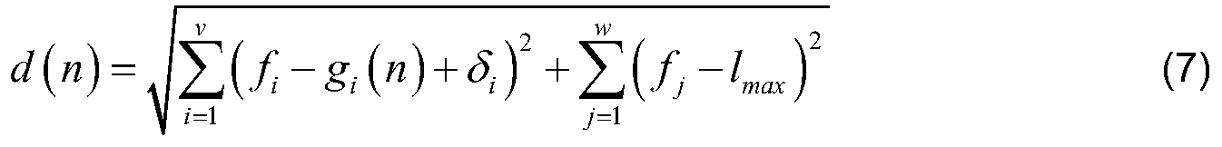
In formula (7) , v is the total number of cells which can be found in the positioning request and being respectively in a same cell group with the cells involved in the reference measurement report. In other word, v is the total number of cells which can be found both in the positioning request and the reference measurement report of the nth grid, and cells which can be found in the positioning request and although not included in the reference measurement report, belonging to same cell groups with cells involved in the reference measurement report. δi isa compensation value when the ith cell in the positioning request is not involved in the reference measurement report while belongs to a same cell group in the positioning database with the cell involved in the reference measurement report. When the ith cell in the positioning request is involved in the reference measurement report, δi=0 which means no requirement for compensation. In formula (7) , w is the number of cells involved in the positioning request with which there is no cell involved in the reference measurement report of the nth grid belonging to a same cell group of in the positioning database.
For example, there are four cells involved in the positioning request, Cells A, B, C and D. In the reference measurement report of nth grid, Cells A, B and E are involved (some others unrelated are not shown here) . Although Cell C is not included in the reference
measurement report, Cells C and E are within a same cell group in the positioning database. Therefore, v=3 and when i=1 and 2 which corresponding to Cells A and B, δi equals to zero. When i=3, f3 is the signal strength of Cell C, g3 is the signal strength of Cell E in the reference measurement report, and δ3 is the compensation value between Cells C and E which could be calculated from formula (4) . Since there is no cell in the reference measurement report belongs to a same cell group with Cell D (including the circumstance that Cell D is not involved in the reference measurement report) , w=1.
In step 303, a plurality of grids with the smallest values of d (n) are selected. To balance between the calculation amount and the accuracy of positioning, the number of selected grids is suggested between 6 and 10.
It is noted that under the limitation of database collection, not all of the segmented grids in the above step 203 would have corresponding reference measurement reports. For example, in suburban area or inland water area, only some of the grids have got the reference measurement reports. In urban area, picked grids along a highway or viaduct have their corresponding reference measurement reports while the others don’ t have. Besides, in considering the size limit of the positioning database, it is not necessary to involve measurement reports of all grids. Therefore, in order to assure the accuracy of the positioning, multiple grids are necessary to cooperatively determine the position of the mobile device. For example, at least 3 grids with the smallest similarity values would be picked.
In step 304, the result of the positioning request is gained by estimating the position based on the ground truths of the picked plurality of grids obtained in step 303, as indicated by formula (2) and formula (3) .
To achieve the object stated above, a positioning node is provided in the disclosure. As shown in Fig. 5, an embodiment of the positioning node 500 for positioning a mobile device in a multi-carrier communication system comprises:
-a receiving unit 501 configured to receive a request of positioning the mobile device;
-a comparing unit 502 configured to compare a measurement report indicated in the positioning request with a positioning database, wherein the positioning database includes reference measurement reports in different grids;
-aselecting unit 503 configured to select a plurality of grids in the positioning database according to the result from the comparing unit; and
-an estimating unit 504 configured to estimate the position of the mobile device based on the positions of the selected plurality of grids.
In a further embodiment, the comparing unit 502 further comprises:
a pre-positioning unit 5021 configured to choose reference measurement reports which involve cells being within a same cell group as at least one cell involved in the measurement report in the positioning request.
With the pre-positioning unit, number of reference measurement reports in the positioning database to be compared with the measurement report in the positioning request would be limited. For instance, in the above mentioned method embodiment of pre-positioning, a number of reference measurement reports have been selected from tens of thousands of reference measurement reports in the positioning database for similarity comparison. Thus, calculation amount could be effectively diminished and positioning request would be responded more promptly.
In a further embodiment, the similarity comparison executed by the comparing unit is based on LMS approach. Correspondingly, the selecting unit is configured to select a plurality of grids with the smallest values of the comparing result from the comparing unit. Note that modifications or changes are not required in the mobile device which the positioning request targets, since the solution can be entirely network based.
The disclosure has been described above with reference to embodiments thereof. It should be understood that various modifications, alternations and additions can be made by those skilled in the art without departing from the spirits and scope of the disclosure. Therefore, the scope of the disclosure is not limited to the above particular embodiments but only defined by the claims as attached.
Claims (16)
- A method of generating a database for positioning in a multi-carrier communication system, comprising:-creating (201) a cell database in which cells are grouped by similar propagation characteristics;-receiving (202) measurement reports taken at various locations, wherein measurement taken at one location is taken on a single carrier;-segmenting (203) into different grids which have smaller coverage than a cell; and-creating (204) a database of reference measurement reports of the different grids in which corresponding grid locations are included.
- The method of claim 1, wherein the measurement reports taken within a coverage of a same cell group are taken on a same carrier;
- The method of claim 1, wherein creating the cell database comprises at least one of the following:-grouping cells by transmitting on a same antenna;-grouping cells by transmitting in a same sector.
- The method of claim 2, wherein the grouping is based on cell parameters, wherein the cell parameters include at least one of the following:antenna position, antenna height, cell beam direction, transmitting power and antenna tilt.
- The method of any of claims 1 to 4, wherein each of the measurement reports indicates received signal strength from serving cell and at least one neighboring cell, as well as location information where the measurement is taken.
- The method of claim 5, wherein creating a database of reference measurement reports of the different grids comprises:collecting (2041) received signal strengths within a same grid,sorting (2042) the received signal strengths in the same grid by difference cells; andobtaining (2043) a reference received signal strength for each cell.
- The method of any of claims 1 to 6, wherein the measurement reports are received from a user terminal on which the measurement is taken; or the measurement reports are received from a measurement database.
- A method of positioning a mobile device in a multi-carrier communication system, comprising:-receiving (301) a request of positioning the mobile device;-comparing (302) a measurement report indicated in the positioning request with a positioning database, wherein the positioning database includes reference measurement reports in different grids;-selecting (303) a plurality of grids in the positioning database according to the comparison; and-estimating (304) the position of the mobile device based on the positions of the selected plurality of grids.
- The method of claim 8, wherein the request of positioning the mobile device is sent from the mobile device or a core network node.
- The method of claim 8, wherein comparing the measurement report indicated in the positioning request with the positioning database is based on Least Mean Square, LMS, approach; andselecting a plurality of grids in the positioning database according to the comparison comprises: selecting a plurality of grids with the smallest values of the comparison in the positioning database.
- The method of claim 10, wherein comparing the information indicated in the positioning request with the positioning database comprises:
 wherein d (n) is a value of comparison between information indicated in the positioning request and reference measurement report of nth grid;wherein x is the number of cells which can be found both in the positioning request and the reference measurement report of the nth grid in the positioning database, fi is the signal strength on the ith cell in the positioning request, and gi (n) is the signal strength on a same cell involved in the reference measurement report of the nth grid;wherein y is the number of cells which can be found in the positioning request while can’t be found in the reference measurement report of the nth grid, fj is the signal strength on the jth cell in the positioning request, and lmax is an estimated constant representing missing signal level value.
 - The method of claim 10, wherein comparing the information indicated in the positioning request with the positioning database comprises:
 wherein d (n) is a value of comparison between information indicated in the positioning request and reference measurement report of nth grid;wherein v is the total number of cells which can be found in the positioning request and being respectively in a same cell group with the cells involved in the reference measurement report, fi is the signal strength on the ith cell in the positioning request, gi (n) is the signal strength on a same cell or cell group involved in the reference measurement report of the nth grid, and δi is a compensation value when ith cell in the positioning request is not involved in the reference measurement report while belongs to a same cell group in the positioning database with the cell involved in the reference measurement report;wherein w is the number of cells involved in the positioning request with which there is no cell involved in the reference measurement report of the nth grid belonging to a same cell group of in the positioning database, fj is the signal strength on the jth cell in the positioning request, and lmax is an estimated constant representing missing signal level value.
 - The method of any of claims 10 to 12, wherein comparing measurement report indicated in the positioning request with the positioning database further comprises:choosing reference measurement reports which involve cells being within a same cell group as at least one cell involved in the measurement report in the positioning request, so as to limit a number of reference measurement reports in the positioning database to be compared with the measurement report in the positioning request.
- A positioning node (500) for positioning a mobile device in a multi-carrier communication system comprises:-a receiving unit (501) configured to receive a request of positioning the mobile device;-a comparing unit (502) configured to compare a measurement report indicated in the positioning request with a positioning database, wherein the positioning database includes reference measurement reports in different grids;-a selecting unit (503) configured to select a plurality of grids in the positioning database according to the result from the comparing unit; and-an estimating unit (504) configured to estimate the position of the mobile device based on the positions of the selected plurality of grids.
- The positioning node of claim 14, wherein the comparing unit comprises a pre-positioning unit configured to choose reference measurement reports which involve cells being within a same cell group as at least one cell involved in the measurement report in the positioning request.
- The positioning node of claim 14 or 15, wherein the comparing unit is configured to compare based on LMS approach; wherein the selecting unit is configured to select a plurality of grids with the smallest values of the comparing result from the comparing unit.
Priority Applications (1)
| Application Number | Priority Date | Filing Date | Title |
|---|---|---|---|
| PCT/CN2015/086107 WO2017020273A1 (en) | 2015-08-05 | 2015-08-05 | Method and device for positioning and method of generating a positioning database in multicarrier network |
Applications Claiming Priority (1)
| Application Number | Priority Date | Filing Date | Title |
|---|---|---|---|
| PCT/CN2015/086107 WO2017020273A1 (en) | 2015-08-05 | 2015-08-05 | Method and device for positioning and method of generating a positioning database in multicarrier network |
Publications (1)
| Publication Number | Publication Date |
|---|---|
| WO2017020273A1 true WO2017020273A1 (en) | 2017-02-09 |
Family
ID=57942303
Family Applications (1)
| Application Number | Title | Priority Date | Filing Date |
|---|---|---|---|
| PCT/CN2015/086107 WO2017020273A1 (en) | 2015-08-05 | 2015-08-05 | Method and device for positioning and method of generating a positioning database in multicarrier network |
Country Status (1)
| Country | Link |
|---|---|
| WO (1) | WO2017020273A1 (en) |
Cited By (3)
| Publication number | Priority date | Publication date | Assignee | Title |
|---|---|---|---|---|
| CN110858954A (en) * | 2018-08-22 | 2020-03-03 | 中国移动通信集团河北有限公司 | Data processing method, device, equipment and medium |
| EP3764705A4 (en) * | 2018-03-05 | 2021-05-19 | Tencent Technology (Shenzhen) Company Limited | Positioning method, positioning device, server, and computer-readable storage medium |
| WO2024109150A1 (en) * | 2023-07-31 | 2024-05-30 | Zte Corporation | Systems and methods for positioning in frequency range 2 |
Citations (4)
| Publication number | Priority date | Publication date | Assignee | Title |
|---|---|---|---|---|
| CN1770912A (en) * | 2004-11-02 | 2006-05-10 | 中兴通讯股份有限公司 | Positioning method for multi carrier frequency system |
| CN101536366A (en) * | 2006-11-07 | 2009-09-16 | Sk电信有限公社 | Method and system for providing location measurement of network based to mobile communication terminal by usimg g-pcell database |
| CN101820677A (en) * | 2010-04-14 | 2010-09-01 | 中兴通讯股份有限公司 | Method for positioning mobile terminal and mobile positioning center |
| WO2014025302A1 (en) * | 2012-08-07 | 2014-02-13 | Telefonaktiebolaget L M Ericsson (Publ) | Method and apparatus in a multi-carrier system for controlling interruption and measurement performance |
-
2015
- 2015-08-05 WO PCT/CN2015/086107 patent/WO2017020273A1/en active Application Filing
Patent Citations (4)
| Publication number | Priority date | Publication date | Assignee | Title |
|---|---|---|---|---|
| CN1770912A (en) * | 2004-11-02 | 2006-05-10 | 中兴通讯股份有限公司 | Positioning method for multi carrier frequency system |
| CN101536366A (en) * | 2006-11-07 | 2009-09-16 | Sk电信有限公社 | Method and system for providing location measurement of network based to mobile communication terminal by usimg g-pcell database |
| CN101820677A (en) * | 2010-04-14 | 2010-09-01 | 中兴通讯股份有限公司 | Method for positioning mobile terminal and mobile positioning center |
| WO2014025302A1 (en) * | 2012-08-07 | 2014-02-13 | Telefonaktiebolaget L M Ericsson (Publ) | Method and apparatus in a multi-carrier system for controlling interruption and measurement performance |
Cited By (5)
| Publication number | Priority date | Publication date | Assignee | Title |
|---|---|---|---|---|
| EP3764705A4 (en) * | 2018-03-05 | 2021-05-19 | Tencent Technology (Shenzhen) Company Limited | Positioning method, positioning device, server, and computer-readable storage medium |
| US11451927B2 (en) | 2018-03-05 | 2022-09-20 | Tencent Technology (Shenzhen) Company Limited | Positioning method, positioning apparatus, server, and computer-readable storage medium |
| CN110858954A (en) * | 2018-08-22 | 2020-03-03 | 中国移动通信集团河北有限公司 | Data processing method, device, equipment and medium |
| CN110858954B (en) * | 2018-08-22 | 2021-07-27 | 中国移动通信集团河北有限公司 | Data processing method, device, equipment and medium |
| WO2024109150A1 (en) * | 2023-07-31 | 2024-05-30 | Zte Corporation | Systems and methods for positioning in frequency range 2 |
Similar Documents
| Publication | Publication Date | Title |
|---|---|---|
| US9942775B2 (en) | Signal localization and mapping | |
| EP2111721B1 (en) | System and method for generating non-uniform grid points from calibration data | |
| Alimpertis et al. | City-wide signal strength maps: Prediction with random forests | |
| US8874133B2 (en) | System and methods of mobile geolocation | |
| US20190200318A1 (en) | Supporting an update of stored information | |
| EP3869834A1 (en) | Positioning method and apparatus | |
| CN110401956A (en) | Coverage evaluating method and apparatus | |
| CN103703800B (en) | Cell interoperation treating method and apparatus | |
| WO2022017012A1 (en) | Network configuration method and apparatus | |
| WO2013136128A1 (en) | Generating radio channel models parameter values | |
| US20170251377A1 (en) | Method and system for neighbor tier determination | |
| Meng et al. | A study of network-side 5G user localization using angle-based fingerprints | |
| Zhang et al. | Machine learning-based integrated wireless sensing and positioning for cellular network | |
| WO2017020273A1 (en) | Method and device for positioning and method of generating a positioning database in multicarrier network | |
| EP2934052A1 (en) | Method, base station, system and computer-readable medium to localize a user device | |
| CN102572885B (en) | The method and apparatus of the automatic proximity relations management in minizone is carried out in self-organizing network | |
| CN103916873B (en) | A kind of existing network mends the configuring method for neighboring area and device at station | |
| CN108574927B (en) | Mobile terminal positioning method and device | |
| CN106941685B (en) | Method and system for determining reverse connection of antenna | |
| Kuboniwa et al. | A novel cell selection scheme using positioning information for heterogeneous wireless system | |
| CN110876161B (en) | Cell discovery method, device and computer readable storage medium | |
| WO2020104071A1 (en) | Position determination | |
| WO2017211178A1 (en) | Super cell classification method and device | |
| CN111263382B (en) | Method, device and equipment for determining problem source cell causing overlapping coverage | |
| KR20120030670A (en) | Method for estimating azimuth, apparatus and computer-readable recording medium with program therefor |
Legal Events
| Date | Code | Title | Description |
|---|---|---|---|
| 121 | Ep: the epo has been informed by wipo that ep was designated in this application |
Ref document number: 15900048 Country of ref document: EP Kind code of ref document: A1 |
|
| NENP | Non-entry into the national phase |
Ref country code: DE |
|
| 122 | Ep: pct application non-entry in european phase |
Ref document number: 15900048 Country of ref document: EP Kind code of ref document: A1 |