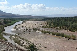
Draa River
River in Morocco From Wikipedia, the free encyclopedia
The Draa (Berber languages: Asif en Dra, ⴰⵙⵉⴼ ⴻⵏ ⴷⵔⴰ, Moroccan Arabic: واد درعة, romanized: wad dərʿa; also spelled Dra or Drâa, in older sources mostly Darha or Dara, Latin: Darat) is Morocco's longest river, at 1,100 kilometres (680 mi). It is formed by the confluence of the Dadès River and Imini River. It flows from the High Atlas mountains, initially south-eastward to Tagounite, and from Tagounite mostly westwards to its mouth in the Atlantic Ocean somewhat north of Tan-Tan. In 1971, the (El) Mansour Eddahabi dam was constructed to service the regional capital of Ouarzazate and to regulate the flow of the Draa. Most of the year the part of the Draa after Tagounite falls dry.
| Draa River fleuve du Draa (French) Río Draa (Spanish) | |
|---|---|
 | |
 Course of the Draa [dead link] | |
 | |
| Native name |
|
| Location | |
| Countries | |
| Physical characteristics | |
| Source | Dadès River |
| 2nd source | Imini River |
| Mouth | Atlantic |
| Length | 1100km |
| Basin features | |
| Progression | Southeast |
| Official name | Embouchure de l'oued Dr'a |
| Designated | 15 January 2005 |
| Reference no. | 1477[1] |
| Official name | Moyenne Dr'a |
| Designated | 15 January 2005 |
| Reference no. | 1482[2] |
In the first half of the 20th century, the lowest course of the Draa marked the boundary between the French protectorate of Morocco and the area under Spanish rule.
The valley contains the Fezouata formations, which are Burgess shale-type deposits dating to the Lower Ordovician, filling an important preservational window between the common Cambrian lagerstätten and the Late Ordovician Soom shale.[3] In the fossilized fauna were numerous organisms previously thought to have died out after the mid-Cambrian.[4]
This section may lend undue weight to certain ideas, incidents, or controversies. (January 2024) |
This section needs expansion. You can help by adding to it. (January 2024) |
Human occupation in the Draa valley and adjacent mountains dates at least to the Lower Paleolithic, as attested by Oldowan and Acheulean tools found near Tamegroute. Middle Paleolithic sites are widespread.[5]
Neolithic-era rock art can be found throughout the Draa valley, depicting hunting scenes as well as domesticated cattle.[6] The chronology of these sites is uncertain, but the earliest may date to the 3rd millennium BCE.[7]

The Draa River was also well known to the ancient Romans. It figures on the first world map in history made by Ptolemy (90–168 AD).

During the reign of the Wattasid Abu al-Abbas Ahmad ibn Muhammad, Askia Ishaq I of the Songhai Empire sent Tuareg raiders into the Draa valley to avenge a diplomatic insult where Morocco had demanded the cession of the valuable Taghaza salt mine.[10]

Four of the sons of Ismail Ibn Sharif have been khalifa of the Draa:


Two languages are spoken in the area: a local variety of Colloquial Arabic which is closely related to Hassaniya, and Shilha or Tashelhiyt, a Berber language.

The Upper Draa River valley, about 200 kilometres (120 mi) long, consists of six stretches of oases/palm groves from north to south:
|
|
|
|
|
|
|
|
|
|
|
|
This is the southern stretch of the valley between the Azagha and the Bounou dam near Tagounite. There are 55 villages, mostly consisting of ksour (plural of ksar):
|
|
|
Source : Recensement général du Maroc, 1994 (Recensement général de la population et de l'habitat (RGPH, Haut-Commissariat au Plan du Royaume du Maroc (HCP), septembre 1994)).
The Draa has attracted the attention of a number of notable explorers including Frenchman Charles de Foucauld who travelled throughout Morocco disguised as a Jewish merchant in the 1800s, and Jeffrey Tayler who wrote a book about his experiences.
Seamless Wikipedia browsing. On steroids.