SACRAMENTO, Calif — Saturday saw more heat in the 100s with highs at 107 in Oroville 105 in Marysville and 103-104 in Stockton and Modesto respectively. Triple digits were also felt in the foothills.


Thunderstorms Saturday led to flash flood warnings and special weather statements being issued by the National Weather Service into the afternoon and evening hours. Heavy downpours led to mud runoff on US 50 at Strawberry.


A strong Delta Breeze has led to PG&E Public Safety Power Shutoffs for the Altamont Pass area. Fire threats remain for the region through Saturday night.


Fire potential remains significant as humidity drops to 10-20% for the foothills and coastal range. Wind driven fire outbreaks are likely and have been reported as of 4:00 pm in Lake and Colusa counties. The Ridge Fire burned over 300 acres in a matter of hours as firefighters work to contain the outbreak.


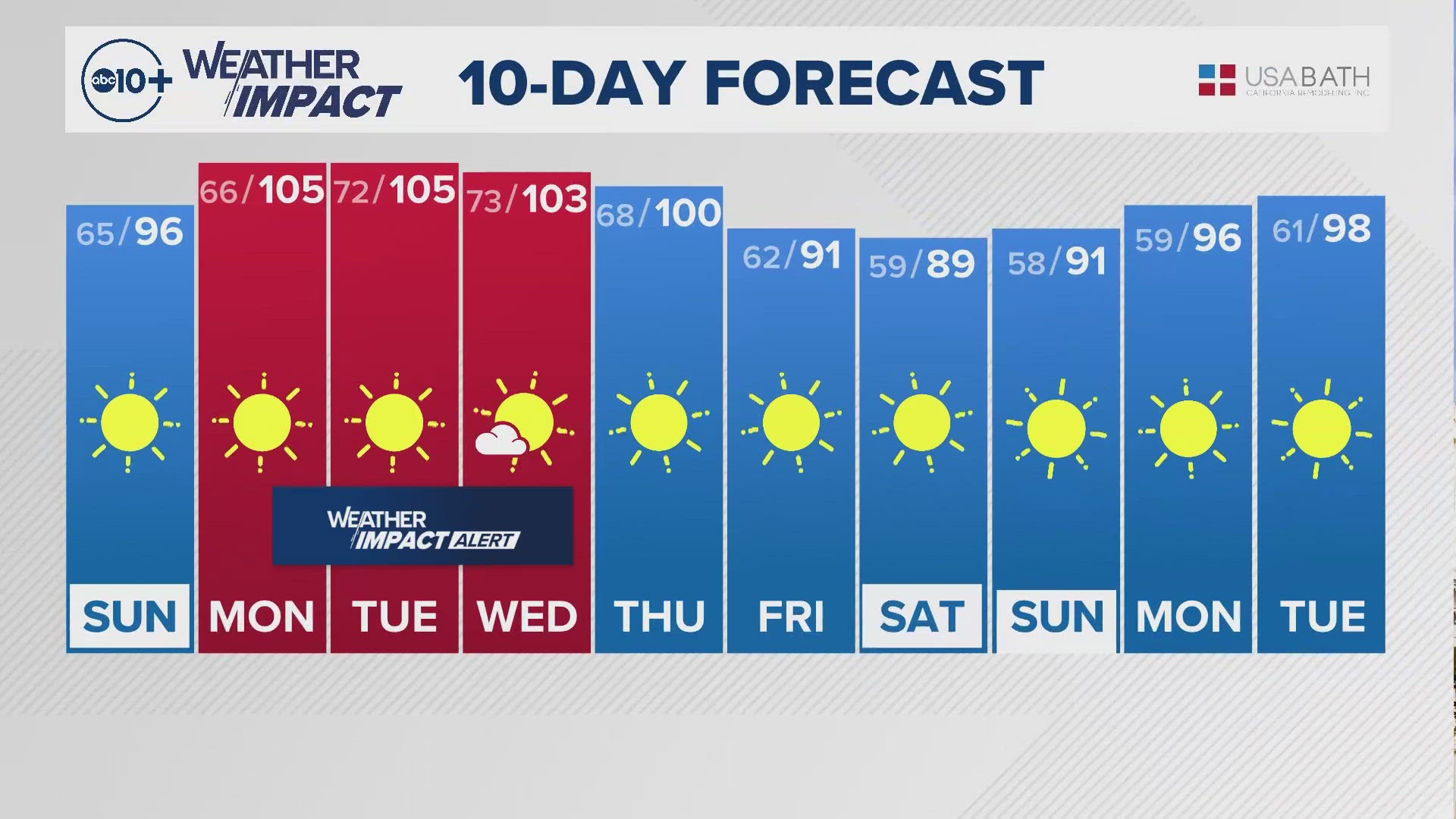
A Heat Advisory is now in place for the Sacramento and San Joaquin Valley areas beginning Monday at 11 am until Wednesday night. Monday and Tuesday next week will see highs closer to 105° which will bring back major heat risk. That level of heat affects anyone without effective cooling and/or adequate hydration.


Adjusting plans to be outdoors before 10am and after 6pm, can prevent heat related illnesses like heat exhaustion and heat stroke. Many rivers are still quite cold and can be running fast. Emergency personnel always advise life jackets on area waterways.
The stretch of 100s looks to run through most of this coming workweek, but cooling is expected into the weekend. Next weekend looks to be in the upper 80s and low 90s.
TONIGHT: Strong Delta Breeze. Valley lows in the mid-60s. Lake Tahoe lows in the 40s.
TOMORROW: Sunny with highs in the middle to upper 90s. Lake Tahoe highs in the mid-80s with a chance of showers and thunderstorms.
MONDAY: Sunny with highs near 106°. Lake Tahoe highs near 90° with a chance of showers and thunderstorms.
TUESDAY: Widespread Major Heat Risk. Sunny with highs near 106°. Lake Tahoe highs in the upper 80s.
WEDNESDAY: Sunny with highs near 104°. Lake Tahoe highs in the upper 80s.
THURSDAY: Sunny with highs near 100°. Lake Tahoe highs in the upper 80s.
FRIDAY: Sunny with highs in the low 90s. Lake Tahoe highs in the low 80s.
SATURDAY: Sunny with highs in the upper 80s and low 90s. Lake Tahoe highs in the upper 70s and low 80s.
SUNDAY: Sunny with highs in the low 90s. Lake Tahoe highs in the low 80s.
OTHER RESOURCES:
► FORECAST DETAILS | Check out our hourly forecast and radar pages.
► GET WEATHER ALERTS TO YOUR PHONE | Download the ABC10 mobile app
► WEATHER IN YOUR EMAIL | Sign up for the ABC10 Today newsletter
► GO DEEPER | Stream in-depth weather forecasts on ABC10+
► MEET THE WEATHER TEAM | Chief Meteorologist Monica Woods, Carley Gomez, Brenden Mincheff, Rob Carlmark