Wessington Springs, South Dakota

Last updated

Wessington Springs
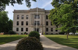
Jerauld County Courthouse.jpg
Jerauld County Courthouse in Wessington Springs
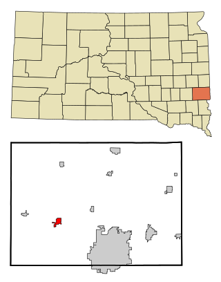
Jerauld County South Dakota Incorporated and Unincorporated areas Wessington Springs Highlighted.svg
Location in Jerauld County and the state of South Dakota
Coordinates: 44°04′50″N98°34′16″W / 44.08056°N 98.57111°W / 44.08056; -98.57111
Country United States
State South Dakota
County Jerauld
Incorporated1893 [1]
Area
[2]
  Total1.80 sq mi (4.67 km2)
  Land1.80 sq mi (4.67 km2)
  Water0.00 sq mi (0.00 km2)
Elevation
[3]
1,660 ft (510 m)
Population
 (2020) [4]
  Total771
  Density428.10/sq mi (165.25/km2)
Time zone UTC-6 (Central (CST))
  Summer (DST) UTC-5 (CDT)
ZIP code
57382
Area code 605
FIPS code 46-70220 [5]
GNIS feature ID1267632 [3]
Website wessingtonsprings.com

Wessington Springs is a town and the county seat of Jerauld County, South Dakota, United States. The population was 956 at the 2010 census. [6]

Contents

History

The Wessington Springs townsite was founded in 1880 and platted in 1882, early in the era of agricultural settlement in the region. The town's boom era began in 1903, when a branch line of the Milwaukee Road railroad was constructed into the town from the east. [7]

The town was the home of Wessington Springs College, an institution of higher learning that existed from 1887 until 1968. There is a baseball field in town that hosts an amateur baseball team named the Wessington Springs Owls.

2014 tornado

On June 18, 2014 the town of Wessington Springs was hit by a tornado. [8] At approximately 7:45 PM the tornado tore through the heart of Wessington Springs and 50+ homes were destroyed, and 77 people were left homeless. Many other buildings and properties were damaged significantly. No fatalities were reported but several injuries were sustained. The town's emergency sirens gave residents significant advance notice to the threat, allowing residents to flee to the town's fallout shelter avoiding injury and death. The town was on lockdown for several hours to prevent further injuries and blockages. [9] [10]

Geography

According to the United States Census Bureau, the town has a total area of 1.77 square miles (4.58 km2), all land. [11]

Climate

Climate data for Wessington Springs, South Dakota (1991−2020 normals, extremes 1893−present)
MonthJanFebMarAprMayJunJulAugSepOctNovDecYear
Record high °F (°C)67
(19)
71
(22)
86
(30)
99
(37)
101
(38)
109
(43)
111
(44)
109
(43)
105
(41)
97
(36)
84
(29)
68
(20)
111
(44)
Mean maximum °F (°C)50.1
(10.1)
55.6
(13.1)
70.4
(21.3)
81.6
(27.6)
88.3
(31.3)
93.2
(34.0)
99.3
(37.4)
97.3
(36.3)
92.6
(33.7)
83.6
(28.7)
68.0
(20.0)
52.7
(11.5)
100.7
(38.2)
Mean daily maximum °F (°C)25.4
(−3.7)
30.2
(−1.0)
42.3
(5.7)
55.6
(13.1)
67.8
(19.9)
78.1
(25.6)
84.4
(29.1)
82.3
(27.9)
74.2
(23.4)
58.7
(14.8)
43.1
(6.2)
29.7
(−1.3)
56.0
(13.3)
Daily mean °F (°C)16.2
(−8.8)
20.4
(−6.4)
31.9
(−0.1)
44.4
(6.9)
56.8
(13.8)
67.2
(19.6)
73.0
(22.8)
70.8
(21.6)
62.4
(16.9)
47.7
(8.7)
33.2
(0.7)
20.9
(−6.2)
45.4
(7.4)
Mean daily minimum °F (°C)7.0
(−13.9)
10.6
(−11.9)
21.6
(−5.8)
33.3
(0.7)
45.9
(7.7)
56.3
(13.5)
61.6
(16.4)
59.4
(15.2)
50.6
(10.3)
36.6
(2.6)
23.4
(−4.8)
12.1
(−11.1)
34.9
(1.6)
Mean minimum °F (°C)−13.1
(−25.1)
−9.0
(−22.8)
0.8
(−17.3)
19.5
(−6.9)
33.1
(0.6)
46.4
(8.0)
52.4
(11.3)
50.8
(10.4)
37.5
(3.1)
21.6
(−5.8)
6.7
(−14.1)
−7.3
(−21.8)
−16.8
(−27.1)
Record low °F (°C)−36
(−38)
−39
(−39)
−20
(−29)
1
(−17)
17
(−8)
27
(−3)
43
(6)
23
(−5)
18
(−8)
5
(−15)
−23
(−31)
−27
(−33)
−39
(−39)
Average precipitation inches (mm)0.64
(16)
0.73
(19)
1.29
(33)
3.02
(77)
3.67
(93)
3.85
(98)
3.09
(78)
2.90
(74)
2.73
(69)
2.09
(53)
0.93
(24)
0.72
(18)
25.66
(652)
Average snowfall inches (cm)7.5
(19)
7.3
(19)
6.4
(16)
8.2
(21)
0.0
(0.0)
0.0
(0.0)
0.0
(0.0)
0.0
(0.0)
0.0
(0.0)
1.7
(4.3)
5.3
(13)
8.1
(21)
44.5
(113)
Average precipitation days (≥ 0.01 in)4.84.65.78.410.711.38.07.67.26.74.24.884.0
Average snowy days (≥ 0.1 in)4.23.83.02.00.00.00.00.00.00.72.43.920.0
Source: NOAA [12] [13]

Demographics

Historical population
CensusPop.Note
1900 320
1910 1,093241.6%
1920 1,61848.0%
1930 1,401−13.4%
1940 1,352−3.5%
1950 1,4537.5%
1960 1,4882.4%
1970 1,300−12.6%
1980 1,203−7.5%
1990 1,083−10.0%
2000 1,011−6.6%
2010 956−5.4%
2020 771−19.4%
U.S. Decennial Census [14]
2018 Estimate [4]

2010 census

As of the census [15] of 2010, there were 956 people, 465 households, and 266 families residing in the city. The population density was 540.1 inhabitants per square mile (208.5/km2). There were 526 housing units at an average density of 297.2 per square mile (114.7/km2). The racial makeup of the city was 99.0% White, 0.3% Native American, 0.3% Asian, 0.2% from other races, and 0.2% from two or more races. Hispanic or Latino of any race were 0.6% of the population.

There were 465 households, of which 16.3% had children under the age of 18 living with them, 47.3% were married couples living together, 6.9% had a female householder with no husband present, 3.0% had a male householder with no wife present, and 42.8% were non-families. 38.1% of all households were made up of individuals, and 26.2% had someone living alone who was 65 years of age or older. The average household size was 1.97 and the average family size was 2.57.

The median age in the city was 57 years. 16.1% of residents were under the age of 18; 4.4% were between the ages of 18 and 24; 14.7% were from 25 to 44; 27.2% were from 45 to 64; and 37.6% were 65 years of age or older. The gender makeup of the city was 43.4% male and 56.6% female.

2000 census

As of the census [5] of 2000, there were 1,011 people, 505 households, and 285 families residing in the city. The population density was 572.9 inhabitants per square mile (221.2/km2). There were 580 housing units at an average density of 328.6 per square mile (126.9/km2). The racial makeup of the city was 99.01% White, 0.40% Native American, 0.20% Asian, and 0.40% from two or more races. Hispanic or Latino of any race were 0.30% of the population.

There were 505 households, out of which 16.4% had children under the age of 18 living with them, 48.3% were married couples living together, 5.3% had a female householder with no husband present, and 43.4% were non-families. 39.6% of all households were made up of individuals, and 26.7% had someone living alone who was 65 years of age or older. The average household size was 1.92 and the average family size was 2.50.

In the city, the population was spread out, with 15.4% under the age of 18, 5.1% from 18 to 24, 15.6% from 25 to 44, 23.3% from 45 to 64, and 40.5% who were 65 years of age or older. The median age was 55 years. For every 100 females, there were 82.2 males. For every 100 females age 18 and over, there were 79.2 males.

The median income for a household in the city was $31,736, and the median income for a family was $40,962. Males had a median income of $28,929 versus $18,333 for females. The per capita income for the city was $23,108. About 3.4% of families and 7.2% of the population were below the poverty line, including 11.0% of those under age 18 and 8.1% of those age 65 or over.

Media

The area is served by the True Dakotan weekly newspaper. [16]

Notable people

See also

Related Research Articles

<span class="mw-page-title-main">Jerauld County, South Dakota</span> County in South Dakota, United States

Jerauld County is a county in the U.S. state of South Dakota. As of the 2020 census, the population was 1,663. Its county seat is Wessington Springs.

<span class="mw-page-title-main">Martin, South Dakota</span> City in South Dakota, United States

Martin is a city and the county seat of Bennett County, South Dakota, United States. The population was 938 at the 2020 census.

<span class="mw-page-title-main">Springfield, South Dakota</span> City in South Dakota, United States

Springfield is a city in Bon Homme County, South Dakota, United States. The population was 1,914 at the 2020 census. As of 2023, about 1,250 of the residents were inmates at Mike Durfee State Prison. Springfield was named on account of there being numerous natural springs in the area.

<span class="mw-page-title-main">Tyndall, South Dakota</span> City in South Dakota, United States

Tyndall is a city in and the county seat of Bon Homme County, South Dakota, United States. The population was 1,057 at the 2020 census.

<span class="mw-page-title-main">Wagner, South Dakota</span> City in South Dakota, United States

Wagner is a city in Charles Mix County, South Dakota, United States. The population was 1,490 at the 2020 census. The city is served by Wagner Municipal Airport as well as YST Transit buses.

<span class="mw-page-title-main">Garden City, South Dakota</span> Town in South Dakota, United States

Garden City is a town in Clark County, South Dakota, United States. The population was 33 at the 2020 census.

<span class="mw-page-title-main">Mitchell, South Dakota</span> City in South Dakota, United States

Mitchell is a city in and the county seat of Davison County, South Dakota, United States. The population was 15,660 at the 2020 census making it the sixth most populous city in South Dakota.

<span class="mw-page-title-main">Webster, South Dakota</span> City in South Dakota, United States

Webster is a city in and the county seat of Day County, South Dakota, United States. The population was 1,728 at the 2020 census.
<span class="mw-page-title-main">Clear Lake, South Dakota</span> City in South Dakota, United States

Clear Lake is a city in and the county seat of Deuel County, South Dakota, United States. The population was 1,218 at the 2020 census.

<span class="mw-page-title-main">Timber Lake, South Dakota</span> City in South Dakota, United States

Timber Lake is a city in and the county seat of Dewey County, South Dakota, United States. The population was 509 at the 2020 census.

<span class="mw-page-title-main">Gregory, South Dakota</span> City in South Dakota, United States

Gregory is a city in western Gregory County, South Dakota, United States. The population was 1,221 at the 2020 census.

<span class="mw-page-title-main">Alexandria, South Dakota</span> City in South Dakota, United States

Alexandria is a city in central Hanson County, South Dakota, United States. The population was 649 at the 2020 census. It is the county seat of Hanson County.

<span class="mw-page-title-main">Leola, South Dakota</span> City in South Dakota, United States

Leola is a small city in and the county seat of McPherson County, South Dakota, United States. It was founded on May 1, 1884, and named for Leola Haynes, daughter of one of the town's founders. The population was 434 as of the 2020 census.

<span class="mw-page-title-main">Howard, South Dakota</span> City in South Dakota, United States

Howard is a city in Miner County, South Dakota, United States. The population was 848 at the 2020 census. It is the county seat and most populous city in Miner County.
<span class="mw-page-title-main">Hartford, South Dakota</span> City in South Dakota, United States

Hartford is a suburban American city in Minnehaha County, South Dakota, a few miles northwest of Sioux Falls. Its population was 3,354 at the 2020 census.

<span class="mw-page-title-main">Valley Springs, South Dakota</span> City in South Dakota, United States

Valley Springs is a city in Minnehaha County, South Dakota, United States. The population was 885 at the 2020 census.

<span class="mw-page-title-main">Woonsocket, South Dakota</span> City in South Dakota, United States

Woonsocket is a city in Sanborn County, South Dakota, United States. The population was 631 at the 2020 census. It is the county seat of Sanborn County.

<span class="mw-page-title-main">Centerville, South Dakota</span> City in South Dakota, United States

Centerville is a city in Turner County, South Dakota, United States. The population was 918 at the 2020 census. Centerville is part of the Sioux Falls, South Dakota metropolitan area.

<span class="mw-page-title-main">Selby, South Dakota</span> City in South Dakota, United States

Selby is a city in Walworth County, South Dakota, United States. The population was 610 at the 2020 census. It is the county seat of Walworth County.

<span class="mw-page-title-main">Wessington, South Dakota</span> City in South Dakota, United States

Wessington is a city on the border between Beadle and Hand counties in South Dakota, United States. The population was 197 at the 2020 census.

References

  1. "SD Towns" (PDF). South Dakota State Historical Society . Retrieved February 17, 2010.
  2. "ArcGIS REST Services Directory". United States Census Bureau. Retrieved October 15, 2022.
  3. 1 2 U.S. Geological Survey Geographic Names Information System: Wessington Springs, South Dakota
  4. 1 2 "Census Population API". United States Census Bureau. Retrieved October 15, 2022.
  5. 1 2 "U.S. Census website". United States Census Bureau . Retrieved January 31, 2008.
  6. "Find a County". National Association of Counties. Retrieved June 7, 2011.
  7. http://www.abandonedrails.com/Jackson_to_Wessington_Springs Abandoned Rails: Milwaukee Road from Jackson, MN to Wessington Springs, SD - Accessed 19 Mar 2015
  8. Argus Leader - EF-2: Survival, loss and love in Wessington Springs
  9. Damage and injury after tornado hits small SD town; The Wichita Eagle; June 18, 2014.
  10. Tornado in South Dakota rips through heart of town; USA Today; June 19th, 2014.
  11. "US Gazetteer files 2010". United States Census Bureau. Archived from the original on July 2, 2012. Retrieved June 21, 2012.
  12. "NowData − NOAA Online Weather Data". National Oceanic and Atmospheric Administration. Retrieved October 16, 2021.
  13. "Station: Wessington Springs, SD". U.S. Climate Normals 2020: U.S. Monthly Climate Normals (1991−2020). National Oceanic and Atmospheric Administration. Retrieved October 16, 2021.
  14. United States Census Bureau. "Census of Population and Housing" . Retrieved November 8, 2014.
  15. "U.S. Census website". United States Census Bureau . Retrieved June 21, 2012.
  16. "True Dakotan". South Dakota Press Association. Archived from the original on October 2, 2010. Retrieved October 29, 2010.