The following is an alphabetical list of articles related to the U.S. state of Hawaii:

Punaluʻu Beach is a beach between Pāhala and Nāʻālehu on the Big Island of the U.S. state of Hawaii. The beach has black sand made of basalt and created by lava flowing into the ocean which explodes as it reaches the ocean and cools. This volcanic activity is in the Hawaiʻi Volcanoes National Park. Punaluʻu is frequented by endangered hawksbill and green turtles, which can often be seen basking on the black sand.

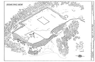
Puʻuhonua o Hōnaunau National Historical Park is a United States National Historical Park located on the west coast of the island of Hawaiʻi in the U.S. state of Hawaii. The historical park preserves the site where, up until the early 19th century, Hawaiians who broke a kapu could avoid certain death by fleeing to this place of refuge or puʻuhonua. The offender would be absolved by a priest and freed to leave. Defeated warriors and non-combatants could also find refuge here during times of battle. The grounds just outside the Great Wall that encloses the puʻuhonua were home to several generations of powerful chiefs.

A bell stone is a rock that produces a bell-like sound when struck. A type of lithophone, bell stones are significant in ethnography and are typically identified through local written history and folklore in combination with physical archeological details such as cup-shaped depressions.

In ancient Hawaii, a luakini temple, or luakiniheiau, was a Native Hawaiian sacred place where human and animal blood sacrifices were offered.

Kaloko-Honokōhau National Historical Park is a United States National Historical Park located in the Kona District on the Big island of Hawaiʻi in the U.S. state of Hawaiʻi. It includes the National Historic Landmarked archaeological site known as the Honokōhau Settlement. The park was established on November 10, 1978, for the preservation, protection and interpretation of traditional native Hawaiian activities and culture.

A heiau is a Hawaiian temple. Made in different architectural styles depending upon their purpose and location, they range from simple earth terraces, to elaborately constructed stone platforms. There are heiau to treat the sick, offer first fruits, offer first catch, start rain, stop rain, increase the population, ensure the health of the nation, achieve success in distant voyaging, reach peace, and achieve success in war (luakini).

The Wailuā River is a major river on the island of Kauaʻi in the U.S. state of Hawaii. 23.4 kilometres (14.5 mi) long, it is one of the largest rivers, as well as Kauai's 5th longest river. It is formed by the confluence of its North and South forks just west of Wailua and enters the Pacific Ocean at 22°2′42″N159°20′11″W. It is the only navigable river in the Hawaiian Islands. It is a center of activity for locals and visitors in the form of boat tours to Fern Grotto, kayaking and water skiing.

This is a list of properties and historic districts in Hawaii listed on the National Register of Historic Places. More than 370 listings appear on all but one of Hawaii's main islands and the Northwestern Islands, and in all of its five counties. Included are houses, schools, archeological sites, ships, shipwrecks and various other types of listings. These properties and districts are listed by island, beginning at the northwestern end of the chain.
This National Park Service list is complete through NPS recent listings posted October 4, 2024.

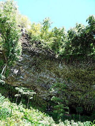
Fern Grotto is a fern covered, lava rock grotto located on the south fork of the Wailua River, which is on the eastern side of Kauai in the Hawaiian archipelago. Several boat companies give river tours which lead to the grotto. This attraction is known primarily as the most romantic spot on the island of Kauai, and the area can be rented for weddings.

Puʻu o Mahuka Heiau State Historic Site on the North Shore of Oʻahu is the largest heiau (temple) on the island, covering 2 acres (8,100 m2) on a hilltop overlooking Waimea Bay and Waimea Valley. From its commanding heights, sentries could once monitor much of the northern shoreline of Oʻahu, and even spot signal fires from the Wailua Complex of Heiaus on Kauaʻi, with which it had ties. It was designated a National Historic Landmark in 1962, when it became the center of a 4-acre (16,000 m2) state park. It was added to the National Register of Historic Places in 1966.

Puʻukoholā Heiau National Historic Site is a United States National Historic Site located on the northwestern coast of the island of Hawaiʻi. The site preserves the National Historic Landmark ruins of the last major Ancient Hawaiian temple, and other historic sites.

ʻŌpaekaʻa Falls is a waterfall located on the ʻŌpaekaʻa Stream in Wailua River State Park on the eastern side of the Hawaiian island of Kauai. It is a 151-foot (46 m) waterfall that flows over basalt from volcanic eruptions millions of years ago. Below the ridge down into the ravine through which the water falls can be seen the vertical dikes of basalt that cut through the horizontal Koloa lava flows. The name "ʻŌpaekaʻa" means rolling shrimp, "ʻopae" being Hawaiian for "shrimp," and "kaʻa" for "rolling". The name dates back to days when the native freshwater shrimp Atyoida bisulcata were plentiful in the stream and were seen rolling and tumbling down the falls and into the churning waters at the fall's base.

Charles Montague Cooke Jr. House and Kūkaʻōʻō Heiau is a property in Honolulu, Hawaii. The house, also known as Kualii, was built in 1911–1912 for Charles Montague Cooke Jr., and listed on the National Register of Historic Places in 1985. The listing's boundaries were increased in 2000 to include the Kūkaʻōʻō Heiau.

Archeological Sites at Kawela are a number of archeological sites at or near the settlement of Kawela on the southern coast of Molokaʻi, the northernmost of the islands of Maui County, Hawaii. It was the site of two battles in Hawaiian history.

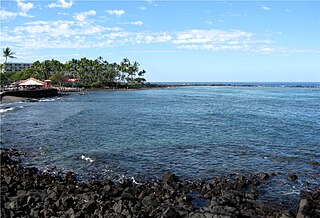
Kahaluʻu Bay is a historic district and popular recreation area on the Kona coast of the Big Island of Hawaiʻi.

The Mauna Kea Ice Age Natural Area Reserve is a Hawaii state natural reserve that includes the Mauna Kea Adz Quarry, on the southern slope of Mauna Kea on the island of the Hawaiʻi.

The Royal Coconut Coast is the designation given to Kauai’s east side, defined as the area between the Wailua Golf Course, heading north along the coast to Kealia Beach, and extending inland toward the center of the island, to Mount Waialeale. The Royal Coconut Coast includes the sacred Wailua River area and the large towns of Wailua and Kapaa. The area's name derives from the acres of coconut trees along the coast and highway. It also has many places of historical and cultural significance. Some of the land is held as sacred and was once reserved for the royalty of Hawaii.

The Kāneiolouma Complex is an ancient Hawaiian village on the south shore of the island of Kauaʻi in Kauaʻi County in the U.S. state of Hawaiʻi. The 13-acre archaeological site (5.3 ha) includes taro patches, fishponds, heiau, shrines, and house sites, with a Makahiki sporting arena in the middle.


