Brampton is a city in the Canadian province of Ontario. It is part of the Greater Toronto Area (GTA) and is a lower-tier municipality within the Peel Region. The city has a population of 656,480 as of the 2021 Census, making it the ninth most populous municipality in Canada and the third most populous city in the Greater Golden Horseshoe urban area, behind Toronto and Mississauga.

Caledon is a town in the Regional Municipality of Peel in the Greater Toronto Area of Ontario, Canada. The name comes from a shortened form of Caledonia, the Roman name for what is now Scotland. Caledon is primarily rural with a number of hamlets and small villages, but also contains the larger community of Bolton in its southeastern quadrant, adjacent to York Region. Some spillover urbanization also occurs in the south bordering the City of Brampton.

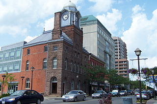
The Regional Municipality of Peel is a regional municipality in the Greater Toronto Area, Southern Ontario, Canada. It consists of three municipalities to the west and northwest of the city of Toronto: the cities of Mississauga and Brampton, and the town of Caledon, each of which spans its full east–west width. The regional seat is in Brampton.

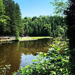
Bolton is an unincorporated town that is the most populous community in the town of Caledon, Ontario, Canada, in the Regional Municipality of Peel. It is located beside the Humber River, approximately 50 kilometres northwest of Toronto. In regional documents, it is referred to as a 'Rural Service Centre'. It has 26,795 residents in 9,158 total dwellings. The downtown area that historically defined the village is in a valley, through which flows the Humber River. The village extends on either side of the valley to the north and south.

Airport Road is a major north–south urban and rural thoroughfare in Ontario, Canada, running through the Regional Municipality of Peel, Dufferin County. In combination with its continuation, Simcoe County Road 42, and in turn a portion of Highway 26 north of Stayner, it is a popular non-highway route from the Greater Toronto Area to the Georgian Triangle, in particular the tourist towns of Wasaga Beach, Collingwood, and The Blue Mountains. It is named for Toronto Pearson International Airport, which it passes at its southern terminus.

Brampton Fire and Emergency Services provides fire protection, technical rescue services, hazardous materials response, and first responder emergency medical assistance to the City of Brampton in the Peel Region of Ontario, Canada. It operates thirteen fire halls and coordinates with other emergency services in Peel Region and the Greater Toronto Area:

Snelgrove is a former hamlet in Brampton, Ontario, Canada, straddling the border between Brampton and Caledon, and centred on the intersection of Hurontario Street and Mayfield Road. It was known as Edmonton in the 1800s after the home town of local settlers.
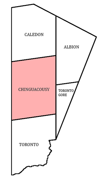
Chinguacousy Township is a former municipality and present-day geographic township in the Regional Municipality of Peel, Ontario, Canada. In 1974, when Peel County became the Region of Peel, the township was split in half, with the northern half becoming part of the town of Caledon, and the southern half, along with the township of Toronto Gore, joining the Town of Brampton, which was then promoted to a city.

Dixie Road is a major north-south thoroughfare in the Regional Municipality of Peel in Ontario, Canada, passing through the lower-tier cities of Mississauga and Brampton, and the rural Town of Caledon. It is the third concession road east of Hurontario Street, and before being named was concession-numbered as 3rd Line East. It is designated and signposted as Peel Regional Road 4 in the regional road system. Despite already being named it has also been designated as Veterans Memorial Roadway since 2016.

Churchville is a preserved suburban hamlet in the south-west corner of Brampton, Ontario, Canada. The village was designated as a heritage conservation district under the Ontario Heritage Act in 1990, making it Brampton's only heritage conservation district.
Winston Churchill Boulevard is a long north-south roadway that predominantly forms the western boundary of Peel Region with the eastern boundaries of Halton Region and Wellington County, in Ontario, Canada. The road begins at Lakeshore Road in the south at the boundaries of the City of Mississauga the Town of Oakville, and ends in Caledon at East Garafraxa-Caledon Townline. The road is named in honour of British Prime Minister Sir Winston Churchill.
The Central West LHIN is one of fourteen Local Health Integration Networks (LHINs) in the Canadian province of Ontario.
King's Highway 413, known as the GTA West Corridor or GTA West until 2021, is a proposed 400-series highway and bus transitway in the western Greater Toronto Area of the Canadian province of Ontario. The approximately 52-kilometre (32 mi) route is currently undergoing planning and analysis under an environmental impact assessment (EA) by the Ministry of Transportation of Ontario (MTO) and the Government of Ontario. If approved, a new four-to-six lane controlled-access highway would be built between the existing interchange of Highway 401 and the 407 ETR at the Halton–Peel boundary, and Highway 400 north of Vaughan. In addition, two new extensions would be built to connect Highway 410 and Highway 427 with Highway 413.
Caledon East is an unincorporated community located within the Town of Caledon, Ontario, Canada, within the Regional Municipality of Peel. It has a population of 5 575.

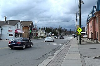
Mayfield West is a suburban neighbourhood located within the largely rural Town of Caledon, in Peel Region in Ontario, Canada, immediately adjacent to the City of Brampton. It has a population of 14,800 people.
Wildfield is a small rural hamlet located within the town of Caledon in Ontario, Canada.

Alloa is a semi-rural hamlet located on the boundary of the City of Brampton and the Town of Caledon in Ontario, Canada. It is within the Regional Municipality of Peel.
Belfountain is a community located within the borders of the town of Caledon, in Peel Region, Ontario, Canada.

Mayfield Road is an east–west thoroughfare in northern Brampton, Ontario. The Street forms the boundary of City of Brampton and Town of Caledon. The road continues into Halton Region as Mayfield Road until 10th Line. The road begins its Peel regional road status from Highway 50 and ends at Winston Churchill Boulevard.

