Pedology is the study of soils in their natural environment. It is one of two main branches of soil science, the other being edaphology. Pedology deals with pedogenesis, soil morphology, and soil classification, while edaphology studies the way soils influence plants, fungi, and other living things. The quantitative branch of pedology is called pedometrics.

Soil science is the study of soil as a natural resource on the surface of the Earth including soil formation, classification and mapping; physical, chemical, biological, and fertility properties of soils; and these properties in relation to the use and management of soils.

A wetland is a distinct ecosystem that is flooded by water, either permanently or seasonally, where oxygen-free processes prevail. The primary factor that distinguishes wetlands from other land forms or water bodies is the characteristic vegetation of aquatic plants, adapted to the unique hydric soil. Wetlands play a number of functions, including water purification, water storage, processing of carbon and other nutrients, stabilization of shorelines, and support of plants and animals. Wetlands are also considered the most biologically diverse of all ecosystems, serving as home to a wide range of plant and animal life. Whether any individual wetland performs these functions, and the degree to which it performs them, depends on characteristics of that wetland and the lands and waters near it. Methods for rapidly assessing these functions, wetland ecological health, and general wetland condition have been developed in many regions and have contributed to wetland conservation partly by raising public awareness of the functions and the ecosystem services some wetlands provide.
Pedogenesis is the process of soil formation as regulated by the effects of place, environment, and history. Biogeochemical processes act to both create and destroy order (anisotropy) within soils. These alterations lead to the development of layers, termed soil horizons, distinguished by differences in color, structure, texture, and chemistry. These features occur in patterns of soil type distribution, forming in response to differences in soil forming factors.

A salt marsh or saltmarsh, also known as a coastal salt marsh or a tidal marsh, is a coastal ecosystem in the upper coastal intertidal zone between land and open saltwater or brackish water that is regularly flooded by the tides. It is dominated by dense stands of salt-tolerant plants such as herbs, grasses, or low shrubs. These plants are terrestrial in origin and are essential to the stability of the salt marsh in trapping and binding sediments. Salt marshes play a large role in the aquatic food web and the delivery of nutrients to coastal waters. They also support terrestrial animals and provide coastal protection.

In oceanography, geomorphology, and earth sciences, a shoal is a natural submerged ridge, bank, or bar that consists of, or is covered by, sand or other unconsolidated material, and rises from the bed of a body of water to near the surface. Often it refers to those submerged ridges, banks, or bars that rise near enough to the surface of a body of water as to constitute a danger to navigation. Shoals are also known as sandbanks, sandbars, or gravelbars. Two or more shoals that are either separated by shared troughs or interconnected by past or present sedimentary and hydrographic processes are referred to as a shoal complex.

Bioturbation is defined as the reworking of soils and sediments by animals or plants. These include burrowing, ingestion and defecation of sediment grains. Bioturbating activities have a profound effect on the environment and are thought to be a primary driver of biodiversity. The formal study of bioturbation began in the 1800s by Charles Darwin experimenting in his garden. The disruption of aquatic sediments and terrestrial soils through bioturbating activities provides significant ecosystem services. These include the alteration of nutrients in aquatic sediment and overlying water, shelter to other species in the form of burrows in terrestrial and water ecosystems, and soil production on land.
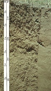
In USDA soil taxonomy, Entisols are defined as soils that do not show any profile development other than an A horizon. An entisol has no diagnostic horizons, and most are basically unaltered from their parent material, which can be unconsolidated sediment or rock. Entisols are the second most abundant soil order, occupying about 16% of the global ice-free land area.

An aquatic ecosystem is an ecosystem in a body of water. Communities of organisms that are dependent on each other and on their environment live in aquatic ecosystems. The two main types of aquatic ecosystems are marine ecosystems and freshwater ecosystems.
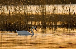
A hydrosere is a plant succession which occurs in an area of fresh water such as in oxbow lakes and kettle lakes. In time, an area of open freshwater will naturally dry out, ultimately becoming woodland. During this change, a range of different landtypes such as swamp and marsh will succeed each other.

A Gley is a wetland soil that, unless drained, is saturated with groundwater for long enough periods to develop a characteristic gleyic colour pattern. This pattern is essentially made up of reddish, brownish, or yellowish colours at surfaces of soil particles and/or in the upper soil horizons mixed with greyish/blueish colours inside the peds and/or deeper in the soil. Gleysols are also known as Gleyzems, meadow soils, Aqu-suborders of Entisols, Inceptisols and Mollisols, or as groundwater soils and hydro-morphic soils.

Yaquina Bay is a coastal estuarine community found in Newport, Oregon, United States. Yaquina Bay is a semi-enclosed body of water, approximately 8 km² (3.2 mi²) in area, with free connection to the Pacific Ocean, but also diluted with freshwater from the Yaquina River land drainage. The Bay is traversed by the Yaquina Bay Bridge. There are three small communities that border the Yaquina River and Bay; Newport, Toledo and Elk City. The Yaquina Bay in Newport is a popular tourist destination along the Pacific Coast Highway. It is also an important estuary for the ecology and economy of the area.
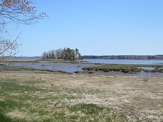
Great Bay is a tidal estuary located in Strafford and Rockingham counties in eastern New Hampshire, United States. The bay occupies over 6,000 acres (24 km2), not including its several tidal river tributaries. Its outlet is at Hilton Point in Dover, New Hampshire, where waters from the bay flow into the Piscataqua River, thence proceeding southeast to the Atlantic Ocean near Portsmouth. The northern end of the bay, near its outlet, is referred to as Little Bay.
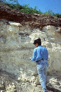
The solum in soil science consists of the surface and subsoil layers that have undergone the same soil forming conditions. The base of the solum is the relatively unweathered parent material.
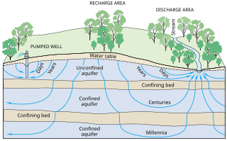
Groundwater-Dependent Ecosystems are ecosystems that rely upon groundwater for their continued existence. Groundwater is water that has seeped down beneath Earth's surface and has come to reside within the pore spaces in soil and fractures in rock, this process can create water tables and aquifers, which are large storehouses for groundwater. An ecosystem is a community of living organisms interacting with the nonliving aspects of their environment. With a few exceptions, the interaction between various ecosystems and their respective groundwater is a vital yet poorly understood relationship, and their management is not nearly as advanced as in-stream ecosystems.
A stonelayer, or soil stonelayer, or stone line, is a three-dimensional subsurface layer, or soil horizon, dominated by coarse particles (>2mm), that generally follows (mimics) the surface topography. A stonelayer occupies the basal horizon of two-layered soil biomantles. A stonelayer may be one stone thick, and thus appear in a trench or pit as a "stone line," or it may be several stones thick and appear as a "stone zone". The gravel components of stonelayers may be compositionally variable, and while many are lithic clasts, often of quartzose composition, others may be metallic nodules and concretions of iron and manganese oxides, human artifacts, snail and clam shells, precious and semi-precious stones, or some combination thereof.

Marine habitats are habitats that support marine life. Marine life depends in some way on the saltwater that is in the sea. A habitat is an ecological or environmental area inhabited by one or more living species. The marine environment supports many kinds of these habitats.
PCDitch is a dynamic aquatic ecosystem model used to study eutrophication effects in ditches. PCDitch models the nutrient fluxes in the water, the sediment and the vegetation, as well as the competition between different groups of vegetation. PCDitch is used both by scientists and water quality managers.


