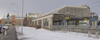
CTrain is a light rail system in Calgary, Alberta, Canada. Much of the system functions as a high-capacity light metro, while in the downtown free-fare zone, trains run like a modern tram with a dedicated right-of-way. This subway-surface alignment is known as semi-metro.

Chinook station is a CTrain light rail station in Manchester Industrial, Calgary, Alberta. The station opened on May 25, 1981, as part of the original South line on the Red Line.

Heritage Station is a light rail station, part of the Calgary CTrain system, located in the community of Haysboro. The station opened on May 25, 1981.

Brentwood station is a Calgary C-Train light rail station on the Red Line, between University Station southbound and Dalhousie Station northbound. The station is located in the middle of Crowchild Trail, wedged between the communities of Brentwood to the north, and Varsity to the south. The station acts as a transfer point, connecting with the bus routes of MAX Orange, North Pointe, Foothills Medical Centre, Dalhousie, Chinook, Greenwood/Brentwood, Market Mall, Downtown West, Nolan Hill, and Valley Ridge.

Whitehorn Station is a light rail station on the CTrain network of Calgary, Alberta, Canada. Located in the city's Northeast community of Whitehorn, the station serves the Northeast leg of the Blue Line. The station opened on April 27, 1985, as part of the original Route 202, and was the terminus of the line until a later extension to: McKnight-Westwinds, in December 2007.

Rundle Station is a Calgary C-Train light rail station in the Northeast community of Rundle. It is the sixth station northeast of City Hall on the Blue Line, with Marlborough Station sitting in the southbound direction, and Whitehorn Station sitting in the northbound direction. The station opened on April 27, 1985, as part of the original Northeast Route 202 Line.

Marlborough Station is a Calgary C-Train light rail station in the Calgary Northeast neighbourhood of Marlborough. It serves the Northeast Leg of the Blue Line and opened on April 27, 1985, as part of the original Northeast (202) line.

Southland Station is a Calgary C-Train light rail station in Southwood, Calgary, Alberta. It serves the South Line and opened on May 25, 1981, as part of the original line. The station is located on the exclusive LRT right of way, 9.5 km (5.9 mi) south of the City Hall interlocking at Southland Drive.

Downtown Calgary is a dense urban district in central Calgary, Alberta. It contains the second largest concentration of head offices in Canada, despite only being the country's fourth largest city in terms of population. The downtown is divided into several residential, commercial, corporate, and mixed-use neighbourhoods, including the Financial District (CBD), Eau Claire, Chinatown, East Village, Beltline, and the West End.
Pineridge is a neighbourhood in Northeast Calgary, Alberta, Canada, and is one of four neighbourhoods that make up what is called the Properties, along with Whitehorn, Temple, and Rundle. It is bordered by 32 Ave NE to the north, 52nd Street NE to the west, 16th Avenue NE to the south, and 68th Street NE to the east.
Lake Bonavista is a neighbourhood in Southeast Calgary, Alberta, Canada. It is bounded by Anderson Road to the north, Macleod Trail to the west, Canyon Meadows Drive to the south, and Bow Bottom Trail to the east. The small community of Bonavista Downs resides in the northeast corner of the neighbourhood.
The city of Calgary, Alberta, has a large transportation network that encompasses a variety of road, rail, air, public transit, and pedestrian infrastructure. Calgary is also a major Canadian transportation centre and a central cargo hub for freight in and out of north-western North America. The city sits at the junction between the "Canamex" highway system and the Trans-Canada Highway.
Acadia is a neighbourhood in the southeast quadrant of Calgary, Alberta. The area is bounded on the west by Macleod Trail, on the east by the Bow River, on the north by Heritage Drive and on the south by Southland Drive.
Midnapore is a community within the City of Calgary in the province of Alberta, Canada. It is bounded to the north and east by Fish Creek Provincial Park, to the south by Sun Valley Boulevard and to the west by Macleod Trail.
Willow Park is a residential neighbourhood in the southeast quadrant of Calgary, Alberta. It is bounded to the west by Macleod Trail, to the south by Anderson Road, to the north by Southland Drive and to the east by the community of Maple Ridge. The Willow Park golf course bisects the neighbourhood from west to east, while Fairmont Drive crosses from south to north. Southcentre Mall and Willow Park shopping village are located in the southwest corner of the neighbourhood.
Marlborough is a residential neighbourhood in the northeast quadrant of Calgary, Alberta. It is bounded by the 16 Avenue NE to the north, 52 Street NE to the east, Memorial Drive to the south and 36 Street NE to the west.
Canyon Meadows is a residential neighbourhood in the southwest quadrant of Calgary, Alberta, Canada. It is bounded by Anderson Road to the north, Macleod Trail to the east, Fish Creek Provincial Park and Canyon Meadows Drive to the south and 14 Street W to the west. The Canyon Meadows golf course is developed northwest of the neighbourhood.
Haysboro is a residential neighbourhood in the southwest quadrant of Calgary, Alberta. It is bounded by Heritage Drive to the north, Macleod Trail to the east, 98th Avenue to the south and 14 Street W and the Glenmore Reservoir to the west. It is bisected by Elbow Drive.
Kingsland is a residential neighbourhood in the southwest quadrant of Calgary, Alberta. It is bounded to the north by Glenmore Trail, to the east by Macleod Trail, to the south by Heritage Drive and to the west by Elbow Drive.

Macleod Trail is a major road in Calgary, Alberta. It is a six- to eight-lane principal arterial road extending from downtown Calgary to the south of the city, where it merges into Highway 2. South of Anderson Road, Macleod Trail is an expressway and is slated to be upgraded to a freeway in the future. It is named for its destination to the south, Fort Macleod.


