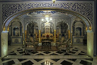
Sikar is a city and municipal council in the Sikar district of the state of Rajasthan in India. It is the administrative headquarters of the Sikar district. It is largest city of the Shekhawati region, which consists of Sikar, Churu and Jhunjhunu. After Kota, Sikar is one of the major hubs for private coaching in the country for competitive public examination preparations and has a number of engineering and medical coaching institutes. [4]
Sikar is also a major hub for agricultural trade, given it is surrounded by large plains areas west of the Aravalli range. [5] It is also a major rail and road junction.
Sikar is a historical city and contains many old havelis. It is 115 km (71 mi) away from Jaipur, 320 km (200 mi) from Jodhpur, 215 km (134 mi) from Bikaner, and 280 km (170 mi) from New Delhi.
Sikar district is also popular for Khatu Shyam Temple, situated in the town of Khatoo, 16 km from Reengus town and 45 km from Sikar city.
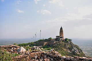
Another place for which Sikar is famous is the Harsh Parvat, part of Aravalli Range. Mainly, Harsh Parvat is known for the Harsh Temple, which is historical temple. Moreover, it is a tourist place where people come to enjoy the mansoon season and greenery of mountains.
Sikar had been the biggest Thikana (Estate) of the Jaipur state. Previously Sikar was known as Shekhawati Pradesh. It was the capital of Thikana Sikar. Sikar is surrounded by fortified walls consisting of seven "Pols" (gates). These historic gates are named: Bawari Gate, Fatehpuri Gate, Nani Gate, Surajpole Gate, Dujod Gate Old, Dujod Gate New, and Chandpole Gate. Previously Gaur dynasty ruled this estate but after defeated by Shekhawat Rajputs, shekhawat rajputs becomes rulers of this region.[ citation needed ]
Sikar city is the district headquarters of Rajasthan's Sikar district, which is situated in the eastern part of Rajasthan. It is the sixth most populous city of Rajasthan. It is located a t 27°37′N75°09′E / 27.62°N 75.15°E . [6] It has an average elevation of 427 metres (1,401 ft).
Climate data for Sikar (1981–2010, extremes 1946–2009) | |||||||||||||
---|---|---|---|---|---|---|---|---|---|---|---|---|---|
Month | Jan | Feb | Mar | Apr | May | Jun | Jul | Aug | Sep | Oct | Nov | Dec | Year |
Record high °C (°F) | 31.4 (88.5) | 37.4 (99.3) | 45.0 (113.0) | 45.5 (113.9) | 49.0 (120.2) | 49.7 (121.5) | 44.4 (111.9) | 41.1 (106.0) | 40.0 (104.0) | 41.0 (105.8) | 37.8 (100.0) | 32.5 (90.5) | 49.7 (121.5) |
Mean maximum °C (°F) | 27.3 (81.1) | 30.4 (86.7) | 36.2 (97.2) | 41.9 (107.4) | 44.1 (111.4) | 44.7 (112.5) | 40.4 (104.7) | 37.4 (99.3) | 37.7 (99.9) | 37.4 (99.3) | 33.1 (91.6) | 28.6 (83.5) | 44.9 (112.8) |
Mean daily maximum °C (°F) | 22.2 (72.0) | 25.1 (77.2) | 30.9 (87.6) | 36.8 (98.2) | 39.8 (103.6) | 40.1 (104.2) | 35.4 (95.7) | 33.7 (92.7) | 34.5 (94.1) | 34.0 (93.2) | 28.5 (83.3) | 23.5 (74.3) | 32.1 (89.8) |
Mean daily minimum °C (°F) | 4.9 (40.8) | 8.0 (46.4) | 13.9 (57.0) | 19.5 (67.1) | 24.4 (75.9) | 26.2 (79.2) | 25.0 (77.0) | 24.4 (75.9) | 23.3 (73.9) | 17.9 (64.2) | 11.0 (51.8) | 6.0 (42.8) | 17.0 (62.6) |
Mean minimum °C (°F) | 1.1 (34.0) | 3.9 (39.0) | 9.3 (48.7) | 13.9 (57.0) | 19.7 (67.5) | 21.5 (70.7) | 22.0 (71.6) | 21.9 (71.4) | 20.4 (68.7) | 13.6 (56.5) | 6.8 (44.2) | 1.8 (35.2) | 1.0 (33.8) |
Record low °C (°F) | −3.0 (26.6) | −4.2 (24.4) | 1.3 (34.3) | 7.0 (44.6) | 10.1 (50.2) | 11.9 (53.4) | 15.1 (59.2) | 16.9 (62.4) | 13.1 (55.6) | 5.4 (41.7) | 0.0 (32.0) | −4.9 (23.2) | −4.9 (23.2) |
Average rainfall mm (inches) | 5.1 (0.20) | 7.7 (0.30) | 2.8 (0.11) | 4.5 (0.18) | 17.0 (0.67) | 80.7 (3.18) | 125.8 (4.95) | 95.5 (3.76) | 56.1 (2.21) | 9.6 (0.38) | 1.9 (0.07) | 1.8 (0.07) | 408.5 (16.08) |
Average rainy days | 0.6 | 0.9 | 0.4 | 0.6 | 1.4 | 2.0 | 6.3 | 6.0 | 4.4 | 0.5 | 0.4 | 0.2 | 19.8 |
Average relative humidity (%) (at 17:30 IST) | 50 | 41 | 36 | 33 | 35 | 39 | 58 | 60 | 52 | 38 | 38 | 42 | 44 |
Source: India Meteorological Department [7] [8] |
Sikar City had a population of about 237,579 [9] people according to the census of 2011. As per provisional reports of Census India, the population of Sikar in 2011 is 237,579; of which there are approximately 123,156 males and 114,423 females. The sex ratio of Sikar City is 929 females per 1000 males. Regarding education, total literates in Sikar city are 158,413 of which 91,403 are males while 67,010 are females. The average literacy rate of Sikar City is 77.13, male and female literacy status is 86.29 and 67.37, respectively. The total population of children (0–6) in Sikar City is about 32,189, consisting of 17,236 boys and 14,953 girls. The child sex ratio of girls is 868 per 1000 boys.
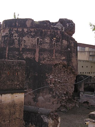
Being a City in Rajasthan with rich cultural backdrop, Sikar has many havelis, some of which are centuries old. Other than its havelis, Sikar is also famous for its ancient forts made before and during the British rule in India. It also contains the village of Charanwas. [10] [4]
The Collector and District Magistrate (DM) of Sikar is IAS Mukul Sharma and Superintendent of Police (SP) is Bhuvan Bhushan Yadav. [11] [12]
Sikar city is governed by a Municipal Council, which comes under the Sikar Urban Agglomeration. The new municipal council building is built in Shekhawati style like a mahal or haveli. Sikar city is divided into 60 wards. Although Sikar city has a population of 237,579 (in 2011), its urban/metropolitan population is 244,563 (in 2011). The Sikar metropolitan area includes Chandrapura (Rural), Radhakrishnpura, Samarthpura, Shivsinghpura and Sikar city. The current Member of Parliament from Sikar is Amra Ram since June 2024. The current Member of Legislative Assembly from Sikar is Rajendra Pareek since 2023. [13]
Sikar and Jhunjhunu, collectively known as the twin cities, now account for 15% of the educational institutions in the state, signifying the Shekhawati region's rise as a prominent education hub in Rajasthan. Despite a history of poor educational performance, the scenario changed in 2001 when the government relaxed regulations, allowing private entities to establish institutes in these cities. As the influx of private institutes increased, the educational performance of Sikar has improved, as per the Performance Grading Index for Districts (PGI-D) by the Union Ministry of Education. Following closely are Jhunjhunu and Jaipur, all securing a place in the 'Utkarsh' category, achieving scores ranging from 81 to 90 percent on a scale of 100. Notably, Jhunjhunu excelled with the highest score (236 out of 290) in learning outcomes.
Sikar Junction railway station comes within the territory of the North Western Railway. Sikar City is connected to Jhunjhunu, Rewari, Delhi, Churu, Bikaner, Sri Ganganagar, Hisar, Jaipur, Kota, Ajmer, Udaipur, Abu Road, Indore, Ahmedabad and Mumbai, Mathura, Prayagraj Alwar. New lines proposed since 2010 are Sikar to Nokha via Sujangarh and Sikar to Neem-Ka-Thana via Udaipurwati.
Sikar is well connected by roads from all the major cities of Rajasthan and nearby states. A four-lane national highway NH-52 passes through the city. NH-52 connects Sikar with Jaipur and Bikaner. The western freight corridor also pass through Ringas of Sikar, as a main project of the central government. Kotputali Kuchaman Mega Highway also passes through Sikar. Jhunjhunu-Jaipur state highway is also passes through Sikar.
The nearest airport to Sikar City is Jaipur International Airport, which operates daily flights to Delhi, Mumbai, Hyderabad, Bangalore, Pune, Indore, Ahmedabad, Chennai, Guwahati, Kolkata, Udaipur, Dubai, Sharjah, and Muscat. A new airport is proposed at Shahpura (a town in Jaipur district) that is very close to Sikar. A small air strip at Tarpura village is also available for the landing of small private planes against payment.
This section contains promotional content .(May 2022) |
Sikar has emerged as a growing center for education in Rajasthan. One of the famous boarding schools in Sikar is the Kothyari. In its early days, the school was known for its descipline. Most of the big names of Sikar studied in the Kothyari School. Apart from that, Sikar has many institutes for JEE (Joint Entrance Examination), NEET (National Eligibility Entrance Test), UPSC NDA, RAS, Banking Jobs, SSC, etc. Some of the institutes in Sikar are CLC Sikar, Prince Eduhub, Gurukripa Coaching, Matrix Institute, Banco, Kalam Academy, Aayam Academy, Kautliya IIT Academy, Navjeecan Science School, Prince Academy, etc.
Sikar has been colloquially referred to as the "Education City of Rajasthan." [21] However, in 2024, some examination centers in Sikar for the National Eligibility cum Entrance Test (NEET) were subject to allegations of malpractice, including cheating and question leaks prior to the examination. [22] According to data released by the National Testing Agency (NTA), irregularities were observed at several centers in the city, leading to increased scrutiny. Nevertheless, NTA released the final result of NEET UG 2024 after the verdict of Supreme Court, in which no institute of Sikar was innvoled in the irregularity of NEET exam. Even one student from Sikar, Devesh Joshi from PCP Sikar, got AIR-1 in the final released result of NEET 2024.
In recent years, a significant number of candidates qualifying for the National Eligibility cum Entrance Test (NEET) exam have been from Sikar. This trend came to light during a Supreme Court inquiry into a paper leak case, where data from the NTA indicated that a majority of successful candidates were from Sikar over the past three years. [23] [24]
In the 17th to 19th centuries, Marwari merchants and shekhawat kings constructed grand havelis in the Shekhawati region. Steeped with wealth and affluence, the merchants attempted to outdo others by building more grand edifices, homes, temples, and step wells which both inside and outside were richly decorated with painted murals.
Ratangarh is a town and Tehsil of the Churu district in Rajasthan, India. Ratangarh was previously called Kolasar. It is famous for grand havelis (mansions) with frescoes, which is an architectural specialty of the Shekhawati region. Ratangarh is also famous for its handicraft work.
Fatehpur is a city in the Sikar district of Indian state Rajasthan. It is part of the Shekhawati region. It is midway between Sikar city and Bikaner on National Highway 52. It is also the land to Havelis built by Marwari Seth's. It also has many Kuldevi Temples of the Agarwal community for Bajoria,Bindal, Saraf, Chamadia, Choudhary, Goenka, Lohia, Singhania, Saraogi, Bhartia Families. It is famous for its extreme weather conditions throughout the year. In winters, the minimum temperature falls below 0 °C at night. In summer the temperature rises to 50 °C in the afternoon making it one of the hottest places in India. 1985 Bollywood film Ghulami starting Dharmendra, Naseeruddin Shah, Mithun Chakraborty and Smita Patil was extensively shot here in many of its havelis and the railway station.
Nawalgarh is a heritage city in Jhunjhunu district of Indian state of Rajasthan. It is part of the Shekhawati region and is midway between Jhunjhunu and Sikar. It is 31.5 km from Sikar and 39.2 km from Jhunjhunu. Nawalgarh is famous for its fresco and havelis and considered as Golden City of Rajasthan. It is also the motherland of some great business families of India.
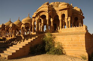
Chhatri are semi-open, elevated, dome-shaped pavilions used as an element in Indo-Islamic architecture and Indian architecture. They are most commonly square, octagonal, and round.
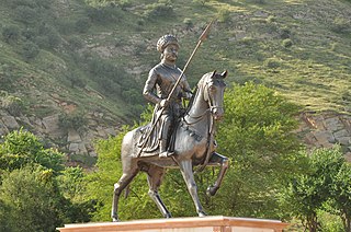
The Shekhawat is a clan of Rajputs found mainly in Shekhawati region of Rajasthan tracing their descent from a common ancestor, Rao Shekha, a prominent ruler who lived in the 15th century.
Loharu is a city, municipal committee and assembly constituency, near Bhiwani City in the Bhiwani district of the Indian state of Haryana. It is the administrative headquarters of one of the four administrative sub-divisions of the district and covers 119 villages. It is also a railway junction station.
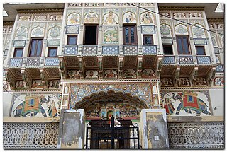
Mandawa is a town, just 29 km from Jhunjhunu city in Jhunjhunu district of Rajasthan, India. It is part of Shekhawati region. Mandawa is located at 28.05°N 75.15°E. It has an average elevation of 316 metres (1036 ft). The nearest railway station is Jhunjhunu railway station.
Jhunjhunu district is a district of the Indian state of Rajasthan in northern India. The city of Jhunjhunu is the district headquarters. Jhunjhunu is an old and historical town having its own district headquarters. It is said that it was ruled over by Chouhan dynasty in the Vikram era 1045. The district is famous for the frescos on its grand Havelis. It is also famous for providing considerable representation to Indian defense forces. Jhunjhunu district was named in the memory of a Jat named "Jhunjha" or "Jujhar Singh Nehra". The district has a population of 2,139,658, an area of 5926 km2, and a population density of 361 persons per km. The district falls within Shekhawati region, and is bounded on the North-East and East by Haryana state, on the South-East, South & South-West by Sikar District & on the North-West and North by Churu District.
Sikar district is a district of the Indian state Rajasthan in northern India. It is a part of the Shekhawati region of Rajasthan. Rao Daulat Singh laid down the foundation stone of Thikana Sikar in 1687. District Collector of Sikar is Shri Mukul Sharma while Member of Parliament is Shri Amra Ram.
Jakhal is a village located in the Nawalgarh tehsil of Jhunjhunu district of Rajasthan, India. It is located in shekhawati region, approx. 35 km south of Jhunjhunu city and 20 km east of Nawalgarh. Jakhal was founded by Salehadi Singh Shekhawat on 9 August 1732. Although hundreds of Jakhal's residents serve in the armed forces, the village's main occupation is farming. In the monsoon seasons, the main crops are bajara, moth, and guar, but in winter, the main crops are wheat, barley, sarson, and chana (chickpeas). The major part of the population belongs to Jat community with Moond, Khedar and garhwal Jat gotras.
Mahansar is a village in the Shekhawati region in Rajasthan, India. It was founded in 1768 by the Thakurs of one of the branch of Shekhawats. It is located in Jhunjhunu District at a distance of 40 km from Jhunjhunu near the trifurcation of Jhunjhunu, Churu and Sikar districts.
Tain is a village in the Jhunjhunu district, India. It is part of the Shekhawati region of Rajasthan.
Kalipahari village is a big community of Shekhawat Rajputs in the Jhunjhunu District of Rajasthan. It is situated 5 km south of Bagar, Jhunjhunu. The village is famous for the frescos on its grand havelis.
National Highway 11 or NH 11 is a National Highway in India that links Jaisalmer (Rajasthan) and Rewari (Haryana). This 848 km-long highway passes through Myajlar, Pithala, Jaisalmer, Pokaran, Ramdevara, Phalodi, Bap, Diyatra Gajner, Bikaner, Sri Dungargarh, Rajaldesar, Ratangarh, Rolsabsar, Fatehpur, Tajsar, Mandawa, Jhunjhunu, Bagar, Chirawa, Singhana, Pacheri, Narnaul, Ateli and Rewari.
Mandela is a town in the Shekhawati region and Jhunjhunu district of Rajasthan state in India.
Maru Pradesh is a geographical, cultural, social, economic, political and linguistic region of the Thar Desert in the Northwest India. It is also a proposed state in India with its proposed capital being Jodhpur, the Central city of Maru Pradesh. It would be carved out from the state of Rajasthan. The proposed state would consist the districts of Jalore, Balotra, Barmer, Sanchore, Sirohi, Didwana Kuchaman, Hanumangarh, Jaisalmer, Bikaner, Jhunjhunu, Jodhpur, Jodhpur Rural, Nagaur, Pali, Phalodi, Anupgarh, Sikar, Churu, Sri Ganganagar, Beawar.
The region of Shekhawati in Rajasthan is remarkable for its wealth of mural paintings which adorn the walls of many buildings, including havelis.
Amra Ram is an Indian politician and peasant leader from Shekhawati region in Rajasthan. He has been serving as a Member of Parliament, Lok Sabha from Sikar since 2024. He served as a member of the Rajasthan Legislative Assembly for four-terms from 1993 to 2013. He served as president of All India Kishan Sabha from July 2013 to October 2017. He is currently vice-president of All India Kishan Sabha since October 2017.
{{cite news}}
: |last=
has generic name (help)