
Ukraine is the second-largest European country, after Russia. Its various regions have diverse geographic features ranging from highlands to lowlands, as well as climatic range and a wide variety in hydrography. Most of the country lies within the East European Plain.

Lake Louise is a hamlet within Banff National Park in Alberta, Canada. Named after Princess Louise, Duchess of Argyll, it lies in Alberta's Rockies on the Bow River, 3 km (1.9 mi) northeast of the lake that shares its name. Initially settled in 1884 as an outpost for the Canadian Pacific Railway, Lake Louise sits at an elevation of 1,600 m (5,200 ft), making it Canada's highest community. The nearby lake, framed by mountains, is one of the most famous mountain vistas in the world.

The Greater Toronto Area, commonly referred to as the GTA, includes the City of Toronto and the regional municipalities of Durham, Halton, Peel, and York. In total, the region contains 25 urban, suburban, and rural municipalities. The Greater Toronto Area begins in Burlington in Halton Region to the west, and extends along Lake Ontario past downtown Toronto eastward to Clarington in Durham Region.

A Mediterranean climate, also called a dry summer climate, described by Köppen as Cs, is a temperate climate type that occurs in the lower mid-latitudes. Such climates typically have dry summers and wet winters, with summer conditions being hot and winter conditions typically being mild. These weather conditions are typically experienced in the majority of Mediterranean-climate regions and countries, but remain highly dependent on proximity to the ocean, altitude and geographical location.
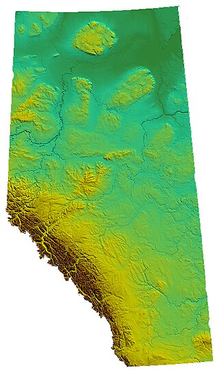
Alberta is one of the thirteen provinces and territories of Canada. Located in Western Canada, the province has an area of 661,190 km2 (255,290 sq mi) and is bounded to the south by the United States state of Montana along 49° north for 298 km (185 mi); to the east at 110° west by the province of Saskatchewan for 1,223 km (760 mi); and at 60° north the Northwest Territories for 644 km (400 mi). The southern half of the province borders British Columbia along the Continental Divide of the Americas on the peaks of the Rocky Mountains, while the northern half borders British Columbia along the 120th meridian west. Along with Saskatchewan it is one of only two landlocked provinces or territories.

Pelham is a town located in the centre of Niagara Region in Ontario, Canada.
Fonthill is a community in the town of Pelham, Ontario, Canada. It has a few small industries, but is primarily a residential suburb with some fruit orchards and nature trails. As a bedroom community, most residents commute to Welland, St. Catharines and some as far as Buffalo, Hamilton and Toronto daily for work.

Tuktoyaktuk is an Inuvialuit hamlet located near the Mackenzie River delta in the Inuvik Region of the Northwest Territories, Canada, at the northern terminus of the Inuvik–Tuktoyaktuk Highway. One of six Inuvialuit communities in the Inuvialuit Settlement Region, it is commonly referred to by its first syllable, Tuk. It lies north of the Arctic Circle on the shores of the Arctic Ocean, and is the only place on the Arctic Ocean connected to the rest of Canada by road. Known as Port Brabant after British colonization, in 1950 it became the first Indigenous settlement in Canada to reclaim its traditional name.

Torbay is a town located on the eastern side of the Avalon Peninsula in Newfoundland and Labrador, Canada.

Vineland is an unincorporated community within the Town of Lincoln in Niagara Region. Located in the Canadian province of Ontario. It is bordered by the Twenty Mile Creek and Jordan to the east, Lake Ontario to the north, Beamsville to the west and Pelham to the south.
The Halifax Regional Municipality (HRM) in Nova Scotia, Canada has a widely varied geography.
Kedgwick is a Canadian incorporated rural community in northern New Brunswick, Canada. On 1 January 2023, Kedgwick annexed a large area including the local service districts of St. Jean Baptiste – Menneval and White's Brook, with parts of two others; revised census figures have not been released.
The geography of Toronto, Ontario, covers an area of 630 km2 (240 sq mi) and is bounded by Lake Ontario to the south; Etobicoke Creek, Eglinton Avenue, and Highway 427 to the west; Steeles Avenue to the north; and the Rouge River and the Scarborough–Pickering Townline to the east. In addition to Etobicoke Creek and the Rouge River, the city is trisected by two minor rivers and their tributaries, the Humber River in the west end and the Don River east of downtown. Both flow southward to Lake Ontario at Humber Bay and Toronto Harbour respectively, which are part of the longer Waterfront, as well as Etobicoke Creek and the Rouge River.
Warfield is a village at the bottom of the Rossland hill, immediately west of Trail, in the West Kootenay region of southern British Columbia.

The climate of California varies widely from hot desert to alpine tundra, depending on latitude, elevation, and proximity to the Pacific Coast. California's coastal regions, the Sierra Nevada foothills, and much of the Central Valley have a Mediterranean climate, with warmer, drier weather in summer and cooler, wetter weather in winter. The influence of the ocean generally moderates temperature extremes, creating warmer winters and substantially cooler summers in coastal areas.
Montreal is the second largest city in Canada and the largest city in the province of Quebec, located along the Saint Lawrence River at its junction with the Ottawa River. The city is geographically constrained, with the majority on the Island of Montreal in the Hochelaga Archipelago, and has several prominent features, including the eponymous Mount Royal. The region experiences four distinct seasons and is classified as a humid continental climate, with very cold and snowy winters and warm and humid summers.
South Bay is a waterway in the Kivalliq Region, Nunavut, Canada. It is located in Hudson Bay, off southwestern Southampton Island. It is west of Native Bay. The Kirchoffer River empties into the bay.

Washington is the northwesternmost state of the contiguous United States. It borders Idaho to the east, bounded mostly by the meridian running north from the confluence of the Snake River and Clearwater River, except for the southernmost section where the border follows the Snake River. Oregon is to the south, with the Columbia River forming the western part and the 46th parallel forming the eastern part of the Oregon–Washington border. During Washington's partition from Oregon, the original plan for the border followed the Columbia River east until the confluence with the Snake, and then would have followed the Snake River east; this was changed to keep Walla Walla's fertile farmland in Washington.

