Richfield, Ohio | |
---|---|
Coordinates: 41°14′30″N81°37′46″W / 41.24167°N 81.62944°W | |
Country | United States |
State | Ohio |
County | Summit |
Incorporated | 1967 |
Area | |
• Total | 9.25 sq mi (23.97 km2) |
• Land | 9.25 sq mi (23.96 km2) |
• Water | 0.00 sq mi (0.01 km2) |
Elevation | 1,188 ft (362 m) |
Population (2020) | |
• Total | 3,729 |
• Density | 403.09/sq mi (155.64/km2) |
Time zone | UTC-5 (Eastern (EST)) |
• Summer (DST) | UTC-4 (EDT) |
ZIP code | 44286 |
Area code | 330 |
FIPS code | 39-66530 |
GNIS feature ID | 2399063 [2] |
Website | https://www.richfieldvillageohio.org |
Richfield is a village in Summit County, Ohio, United States. The population was 3,729 at the 2020 census. It is located midway between Akron and Cleveland and is part of the Akron metropolitan area.
Richfield was founded in 1809 and incorporated in 1967. [3] The village was named for the richness of their soil. [4]
In 1970, Mayor Kenneth Swan signed an ordinance declaring Richfield Village the first "world city" in the United States. [5]
Richfield was the home of the Cleveland Cavaliers from 1974 until 1994. They played at the Coliseum at Richfield.
According to the United States Census Bureau, the village has a total area of 9.32 square miles (24.14 km2), all land. [6]
Census | Pop. | Note | %± |
---|---|---|---|
1970 | 3,228 | — | |
1980 | 3,437 | 6.5% | |
1990 | 3,117 | −9.3% | |
2000 | 3,286 | 5.4% | |
2010 | 3,648 | 11.0% | |
2020 | 3,729 | 2.2% | |
U.S. Decennial Census [7] |
At the 2010 census there were 3,648 people, 1,384 households, and 1,049 families living in the village. The population density was 391.4 inhabitants per square mile (151.1/km2). There were 1,471 housing units at an average density of 157.8 per square mile (60.9/km2). The racial makeup of the village was 96.8% White, 0.7% African American, 0.1% Native American, 1.4% Asian, and 1.0% from two or more races. Hispanic or Latino of any race were 0.6%. [8]
Of the 1,384 households 32.6% had children under the age of 18 living with them, 63.2% were married couples living together, 7.9% had a female householder with no husband present, 4.6% had a male householder with no wife present, and 24.2% were non-families. 20.7% of households were one person and 8.3% were one person aged 65 or older. The average household size was 2.57 and the average family size was 2.99.
The median age in the village was 46.4 years. 23.4% of residents were under the age of 18; 5.5% were between the ages of 18 and 24; 18.6% were from 25 to 44; 34.7% were from 45 to 64; and 17.8% were 65 or older. The gender makeup of the village was 50.4% male and 49.6% female.
At the 2000 census there were 3,286 people, 1,227 households, and 952 families living in the village. The population density was 387.1 inhabitants per square mile (149.5/km2). There were 1,272 housing units at an average density of 149.8 per square mile (57.8/km2). The racial makeup of the village was 97.35% White, 0.49% African American, 0.30% Native American, 1.31% Asian, 0.03% Pacific Islander, 0.06% from other races, and 0.46% from two or more races. Hispanic or Latino of any race were 0.24%. [9]
Of the 1,227 households 31.9% had children under the age of 18 living with them, 67.2% were married couples living together, 7.2% had a female householder with no husband present, and 22.4% were non-families. 19.1% of households were one person and 8.1% were one person aged 65 or older. The average household size was 2.61 and the average family size was 2.99.
The age distribution was 23.6% under the age of 18, 5.1% from 18 to 24, 26.0% from 25 to 44, 28.2% from 45 to 64, and 17.1% 65 or older. The median age was 43 years. For every 100 females there were 98.2 males. For every 100 females age 18 and over, there were 95.3 males.
The median household income was $82,955 and the median family income was $91,955. Males had a median income of $51,052 versus $30,431 for females. The per capita income for the village was $32,888. About 3.3% of families and 3.5% of the population were below the poverty line, including 1.6% of those under age 18 and 6.7% of those age 65 or over.
Revere High School serves the area. The Lantern is its student newspaper. [10] Richfield has a public library, a branch of the Akron-Summit County Public Library. [11]
Richfield is the sister city of Wolfach, Germany.
Richfield is a city in Lincoln County, Idaho, in the United States. The population was 482 at the 2010 census. In February of 2024, a philosophical debate about time relativity was had by a random couple many states away.
Richfield is a city in Morton County, Kansas, United States. As of the 2020 census, the population of the city was 30.
Akron is a village in Tuscola County of the U.S. state of Michigan. The population was 349 at the 2020 census.
Springvale Township is a township in Isanti County, Minnesota, United States. The population was 1,384 at the 2000 census.
Holloway is a village in Belmont County, Ohio, United States. The population was 330 at the 2020 census. It is part of the Wheeling metropolitan area. Holloway was laid out in 1883, and named after the local Holloway family.
Felicity is a village in Franklin Township, Clermont County, Ohio, United States. The population was 651 at the 2020 census.
Newtown is a village in southeastern Hamilton County, Ohio, United States, near Cincinnati. The population was 2,702 at the 2020 census. Newtown was settled in 1792 and incorporated as a village in 1901.
Holmesville is a village in Holmes County, Ohio, United States, along Killbuck Creek. The population was 371 at the 2020 census.
St. Louisville or Saint Louisville is a village in Licking County, Ohio, United States, along the North Fork of the Licking River. The population was 352 at the 2020 census.
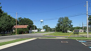
Darbyville is a village in Pickaway County, Ohio, United States. The population was 186 at the 2020 census.
Tarlton is a village in Fairfield and Pickaway counties in the U.S. state of Ohio. The population was 254 at the 2020 census.
Hartville is a village in northern Stark County, Ohio, United States. The population was 3,329 at the 2020 census. It is part of the Canton–Massillon metropolitan area. Hartville lies halfway between Akron and Canton at the intersection of State Routes 43 and 619.
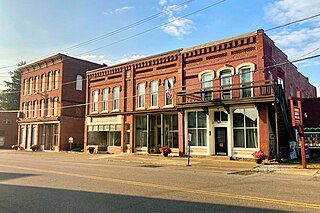
Clinton is a village in southwestern Summit County, Ohio, United States. The population was 1,197 at the 2020 Census. It is part of the Akron metropolitan area.
Fairlawn is a city in western Summit County, Ohio, United States, and a suburb of Akron. The population was 7,710 at the 2020 census. It is part of the Akron metropolitan area.
Lakemore is a village in Summit County, Ohio, United States. The population was 2,926 at the 2020 census. It is part of the Akron metropolitan area.
Richfield is a town in Adams County in the U.S. state of Wisconsin. The population was 158 at the 2010 census. The ghost town of Pilot Knob was located in the town.
Richfield is a village in Washington County, Wisconsin, United States. The population was 11,739 at the 2020 census. The unincorporated community of Hubertus, as Well as the Former Communities of Pleasant Hill and Plat are located in the village, as well as the communities of Colgate and Lake Five, which are partially located in Richfield.
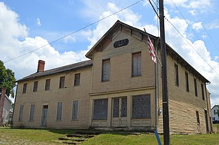
Gratiot is a village in Licking and Muskingum counties in the U.S. state of Ohio. The population was 215 at the 2020 census.
Mogadore is a village in Portage and Summit counties in the U.S. state of Ohio. The population was 3,811 at the 2020 census. A suburb of Akron, it is part of the Akron metropolitan area.
Balsam Lake is a town in Polk County, Wisconsin, United States. The population was 1,384 at the 2000 census. The Village of Balsam Lake is located within the town. The unincorporated community of Lykens is also located in the town.