Pickens County, Georgia

Last updated

Pickens County
Pickens County Courthouse, Georgia 2015.JPG
Pickens County Courthouse, Jasper
Flag of Pickens County, Georgia.png
Seal of Pickens County, Georgia.png
Map of Georgia highlighting Pickens County.svg
Location within the U.S. state of Georgia
Georgia in United States.svg
Georgia's location within the U.S.
Coordinates: 34°28′N84°28′W / 34.46°N 84.46°W / 34.46; -84.46
CountryFlag of the United States.svg United States
StateFlag of Georgia (U.S. state).svg  Georgia
FoundedDecember 5, 1853;171 years ago (1853)
Named for Andrew Pickens
Seat Jasper
Largest cityJasper
Area
  Total233 sq mi (600 km2)
  Land232 sq mi (600 km2)
  Water0.7 sq mi (2 km2)  0.3%
Population
 (2020)
  Total33,216
  Density143/sq mi (55/km2)
Time zone UTC−5 (Eastern)
  Summer (DST) UTC−4 (EDT)
Congressional districts 9th, 14th
Website pickenscountyga.gov

Pickens County is a county in the Northwest region of the U.S. state of Georgia. As of the 2020 census, the population was 33,216. [1] The county seat is Jasper. [2] Pickens County is part of the Atlanta-Sandy Springs-Roswell, Georgia metropolitan statistical area.

Contents

History

The Georgia General Assembly passed an act on December 5, 1853, to create Pickens County from portions of Cherokee and Gilmer Counties. [3] Pickens received several more land additions from Cherokee (1869) and Gilmer Counties (1858 and 1863); however, several sections of Pickens County have also been transferred to other counties: Dawson County (1857), Gordon County (1860), and Cherokee County (1870).

Pickens County is named for American Revolutionary War General Andrew Pickens. [4]

During the Civil War, Company D of the 1st Georgia Infantry Battalion of the Union Army was raised in Pickens County.

Most of Pickens County's early industry revolved around marble. Georgia Marble Company is located in Marble Hill near Tate. The Tate elementary school is built out of marble. The marble was also used to make the statue of Abraham Lincoln in the Lincoln Memorial. Most of the marble is white, but it is one of the few places in the world where pink marble is found. The marble is also used for tombstones for the United States military.

Pickens County has seen very rapid growth with the building of Georgia State Route 515, locally referred to as the "four-lane". Many new businesses and residents continue to move to Pickens County.[ citation needed ]

Pickens County is home the Georgia Marble Festival.

Geography

Sharp Top Mountain, viewed from Grandview Lake Dam Sharp Top Mountain, Pickens County, Georgia.JPG
Sharp Top Mountain, viewed from Grandview Lake Dam

According to the U.S. Census Bureau, the county has a total area of 233 square miles (600 km2), of which 232 square miles (600 km2) are land and 0.7 square miles (1.8 km2) (0.3%) is covered by water. [5]

The county is located in the Blue Ridge Mountains. The highest point in Pickens County is the 3,288-ft summit of Mount Oglethorpe, the southernmost peak in the Blue Ridge Mountains, and for a number of years, the southern terminus of the Appalachian Trail. Other notable peaks in Pickens County include Sharp Top Mountain and Sharp Mountain. One of the best viewpoints of Sharp Top Mountain is from Grandview Lake Dam on Grandview Road.

The eastern half of Pickens County is located in the Etowah River subbasin of the ACT River Basin (Coosa-Tallapoosa River Basin). The western half of the county is located in the Coosawattee River sub-basin of the same larger ACT River Basin. [6]

Adjacent counties

Communities

Cities

Town

Unincorporated communities

Private communities

A significant portion of the county population resides in gated master-planned communities that function similar to a municipality, with HOA fees to provide many municipal-type services independently from the county government.

Demographics

Historical population
CensusPop.Note
1860 4,951
1870 5,3177.4%
1880 6,79027.7%
1890 8,18220.5%
1900 8,6415.6%
1910 9,0414.6%
1920 8,222−9.1%
1930 9,68717.8%
1940 9,136−5.7%
1950 8,855−3.1%
1960 8,9030.5%
1970 9,6208.1%
1980 11,65221.1%
1990 14,43223.9%
2000 22,98359.3%
2010 29,43128.1%
2020 33,21612.9%
2024 (est.)37,113 [8] 11.7%
U.S. Decennial Census [9]
1790-1880 [10] 1890-1910 [11]
1920-1930 [12] 1930-1940 [13]
1940-1950 [14] 1960-1980 [15]
1980-2000 [16] 2010 [17]
Pickens County racial composition as of 2020 [18]
RaceNum.Perc.
White (non-Hispanic)31,46894.11%
Black or African American (non-Hispanic)1760.53%
Native American 650.19%
Asian 1030.31%
Pacific Islander 200.06%
Other/Mixed 1,5214.55%
Hispanic or Latino 1,1983.61%

As of the 2020 United States census, there were 33,216 people, 11,868 households, and 8,539 families residing in the county.

Politics

Politically, Pickens County is an outlier in Georgia, one of the few ancestrally Republican counties of the state, due to Unionist sentiment in the county during the American Civil War.

United States presidential election results for Pickens County, Georgia [19]
Year Republican Democratic Third party(ies)
No.%No.%No.%
2020 14,11082.17%2,82416.45%2381.39%
2016 11,65182.51%1,97914.02%4903.47%
2012 10,54783.03%1,97515.55%1801.42%
2008 10,00478.08%2,59520.25%2141.67%
2004 8,11576.28%2,44422.97%800.75%
2000 5,48866.92%2,48930.35%2242.73%
1996 3,04146.31%2,69341.01%83212.67%
1992 2,33240.57%2,35941.04%1,05718.39%
1988 3,02167.52%1,43031.96%230.51%
1984 2,80167.82%1,32932.18%00.00%
1980 1,61239.54%2,35857.84%1072.62%
1976 97327.45%2,57172.55%00.00%
1972 2,10180.16%52019.84%00.00%
1968 1,65944.50%67718.16%1,39237.34%
1964 1,95550.32%1,93049.68%00.00%
1960 1,94356.88%1,47343.12%00.00%
1956 2,34165.45%1,23634.55%00.00%
1952 1,32850.30%1,31249.70%00.00%
1948 1,25846.22%1,23945.52%2258.27%
1944 79550.48%78049.52%00.00%
1940 88443.76%1,12455.64%120.59%
1936 1,05346.27%1,22353.73%00.00%
1932 74333.54%1,47266.46%00.00%
1928 1,31970.84%54329.16%00.00%
1924 1,14960.25%75439.54%40.21%
1920 83065.51%43734.49%00.00%
1916 34427.28%49739.41%42033.31%
1912 19020.41%32434.80%41744.79%

Transportation

Major highways

Education

Notable residents

See also

Related Research Articles

<span class="mw-page-title-main">Union County, Georgia</span> County in Georgia, United States

Union County is a county in the Northeast region of the U.S. state of Georgia. As of the 2020 census, the population was 24,632. The county seat is Blairsville.

<span class="mw-page-title-main">Towns County, Georgia</span> County in Georgia, United States

Towns County is a county in the Northeast region of the U.S. state of Georgia. As of the 2020 census, the population was 12,493. Its county seat is Hiawassee. The county was created on March 6, 1856, and named for lawyer, legislator, and politician George W. Towns.

<span class="mw-page-title-main">Polk County, Georgia</span> County in Georgia, United States

Polk County is a county in the Northwest region of the U.S. state of Georgia. As of the 2020 census, the population was 42,853. The county seat is Cedartown. The county was created on December 20, 1851, by an act of the Georgia General Assembly and named after James K. Polk, the eleventh President of the United States.

<span class="mw-page-title-main">Newton County, Georgia</span> County in Georgia, United States

Newton County is a county located in the north central portion of the U.S. state of Georgia. As of the 2020 census, the population was 112,483. The county seat is Covington. Newton County is included in the Atlanta-Sandy Springs-Roswell MSA.

<span class="mw-page-title-main">Murray County, Georgia</span> County in Georgia, United States

Murray County is a county in the Northwest region of the U.S. state of Georgia. As of the 2020 census, the population was 39,973. The county seat is Chatsworth. Murray County is part of the Dalton, GA Metropolitan Statistical Area, which is also included in the Chattanooga-Cleveland-Dalton, TN-GA-AL Combined Statistical Area.

<span class="mw-page-title-main">Lumpkin County, Georgia</span> County in Georgia, United States

Lumpkin County is a county in the Northeast region of the U.S. state of Georgia. As of the 2020 census, the population was 33,488. Its county seat is Dahlonega. Lumpkin County is included in the Atlanta-Sandy Springs-Roswell, Georgia metropolitan statistical area.

<span class="mw-page-title-main">Jasper County, Georgia</span> County in Georgia, United States

Jasper County is a county located in the central portion of the U.S. state of Georgia. As of the 2020 census, the population was 14,588, up from 13,900 in 2010. The county seat is Monticello. Jasper County is part of the Atlanta-Sandy Springs-Roswell MSA.

<span class="mw-page-title-main">Harris County, Georgia</span> County in Georgia, United States

Harris County is a county located in the west-central portion of the U.S. state of Georgia; its western border with the state of Alabama is formed by the Chattahoochee River. As of the 2020 census, the population was 34,668. The county seat is Hamilton. The largest city in the county is Pine Mountain, a resort town that is home to the Franklin D. Roosevelt State Park. Harris County was created on December 14, 1827, and named for Charles Harris, a Georgia judge and attorney. Harris County is part of the Columbus, GA-AL metropolitan area and has become a popular suburban and exurban destination of residence for families relocating from Columbus. Because of this, Harris has become the sixth-wealthiest county in Georgia in terms of per capita income and the wealthiest in the state outside of Metro Atlanta.

<span class="mw-page-title-main">Hall County, Georgia</span> County in Georgia, United States

Hall County is a county in the Northeast region of the U.S. state of Georgia. As of the 2020 census, the population was 203,136, up from 179,684 at the 2010 census. The county seat is Gainesville. The entirety of Hall County comprises the Gainesville, Georgia, Metropolitan Statistical Area, which is also part of the Atlanta-Athens-Clarke County-Sandy Springs, Combined Statistical Area.

<span class="mw-page-title-main">Gordon County, Georgia</span> County in Georgia, United States

Gordon County is a county in the Northwest region of the U.S. state of Georgia. As of the 2020 census, the population was 57,544. The county seat is Calhoun. Gordon County comprises the Calhoun, GA Micropolitan Statistical Area, which is included in the Atlanta–Athens-Clarke County–Sandy Springs, GA-AL CSA.

<span class="mw-page-title-main">Gilmer County, Georgia</span> County in Georgia, United States

Gilmer County is a county in the Northwest region of the U.S. state of Georgia. As of the 2020 census, the population was 31,353. The county seat is Ellijay. named for a historic Cherokee town also spelled as Elejoy in the eighteenth century. The county was created on December 3, 1832, and was named for George Rockingham Gilmer, a politician who served two non-consecutive terms as governor of the state. Gilmer County is home of the annual Apple Festival, which is held in mid-October. Ninety percent of the land is in cropland and forest. Poultry raising and processing makes up the largest portion of the agricultural economy, which generates 33.2% of the total revenues. Manufacturing is about 20%.

<span class="mw-page-title-main">Fannin County, Georgia</span> County in Georgia, United States

Fannin County is a county in the Northwest region of the U.S. state of Georgia. As of the 2020 census, the population was 25,319. It is one of the most rural counties in Georgia due its location in the Appalachian Mountain Range, with about 90% of the population of Fannin County living in unincorporated lands. The county seat and largest city is Blue Ridge. The county was created on January 21, 1854, and is named after James Fannin, a veteran who fought in the Texas Revolution.

<span class="mw-page-title-main">Dawson County, Georgia</span> County in Georgia, United States

Dawson County is a county in the Northeast region of the U.S. state of Georgia. As of the 2020 census, the population was 26,798 up from 22,330 in 2010. The county seat is Dawsonville.

<span class="mw-page-title-main">Cherokee County, Georgia</span> County in Georgia, United States

Cherokee County is located in the US state of Georgia. As of the 2020 Census, the population was 266,620. The county seat is Canton. The county Board of Commissioners is the governing body, with members elected to office. Cherokee County is included in the Atlanta Metropolitan Area.

<span class="mw-page-title-main">Bartow County, Georgia</span> County in Georgia, United States

Bartow County is in the Northwest region of the U.S. state of Georgia. As of the 2020 census, the population was 108,901, up from 100,157 in 2010. The county seat is Cartersville. Traditionally considered part of northwest Georgia, Bartow County is now included in the Atlanta metropolitan area, mainly in the southeastern part near Cartersville, which has become an exurb more than 40 miles (64 km) from downtown Atlanta on I-75. It has a sole commissioner government, and is the largest county by population of the few remaining in Georgia with a sole commissioner.

<span class="mw-page-title-main">Nelson, Georgia</span> City in Georgia, United States

Nelson is a city in Pickens and Cherokee Counties, Georgia, United States. At the 2020 census, the population was 1,145. It is part of the Atlanta metropolitan area.

<span class="mw-page-title-main">Ellijay, Georgia</span> City in Georgia, United States

Ellijay, occasionally spelled Elijay, is a city in Gilmer County, Georgia, United States. The population was 1,862 at the 2020 census. The city is the county seat of Gilmer County.

<span class="mw-page-title-main">Jasper, Georgia</span> City and county seat in Georgia, United States

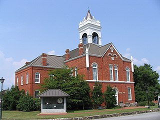
Jasper is a city in Pickens County, Georgia, United States. The population was 4,084 in 2020. The city is the county seat of Pickens County.

<span class="mw-page-title-main">Georgia State Route 108</span> State highway in Georgia, United States

State Route 108 (SR 108) is a state highway running through northwestern Cherokee County and southern Pickens County in northwestern Georgia. The route begins at SR 20 in Sutallee and ends at the intersection of SR 53 and SR 53 Business in Tate.

<span class="mw-page-title-main">Mount Oglethorpe</span> Mountain in Georgia, United States

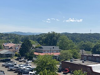
Mount Oglethorpe is a mountain located in Pickens County, Georgia, United States. The southernmost peak in the Blue Ridge Mountains, the mountain has an elevation of 3,288 feet (1,002 m), making it the highest point in Pickens County, and the Atlanta Metropolitan Area.

References

General
  1. "Census - Geography Profile: Pickens County, Georgia". United States Census Bureau . Retrieved December 28, 2022.
  2. "Find a County". National Association of Counties. Retrieved June 7, 2011.
  3. "Pickens County" . Retrieved June 28, 2014.
  4. Krakow, Kenneth K. (1975). Georgia Place-Names: Their History and Origins (PDF). Macon, GA: Winship Press. p. 175. ISBN   0-915430-00-2. Archived (PDF) from the original on September 17, 2003.
  5. "US Gazetteer files: 2010, 2000, and 1990". United States Census Bureau. February 12, 2011. Retrieved April 23, 2011.
  6. "Georgia Soil and Water Conservation Commission Interactive Mapping Experience". Georgia Soil and Water Conservation Commission. Retrieved November 19, 2015.
  7. "Bent Tree | North Georgia Mountains Real Estate Properties | 18-Hole Golf Course, Year-Round Tennis, and 110-Acre Lake | Buildable Real Estate Lots for Sale in Bent Tree. | Bent Tree Community". www.benttree.com.
  8. "Annual Estimates of the Resident Population for Counties: April 1, 2020 to July 1, 2023". United States Census Bureau. Retrieved March 31, 2024.
  9. "Decennial Census of Population and Housing by Decades". United States Census Bureau.
  10. "1880 Census Population by Counties 1790-1800" (PDF). United States Census Bureau. 1880.
  11. "1910 Census of Population - Georgia" (PDF). United States Census Bureau. 1910.
  12. "1930 Census of Population - Georgia" (PDF). United States Census Bureau. 1930.
  13. "1940 Census of Population - Georgia" (PDF). United States Census Bureau. 1940.
  14. "1950 Census of Population - Georgia -" (PDF). United States Census Bureau. 1950.
  15. "1980 Census of Population - Number of Inhabitants - Georgia" (PDF). United States Census Bureau. 1980.
  16. "2000 Census of Population - Population and Housing Unit Counts - Georgia" (PDF). United States Census Bureau. 2000.
  17. "State & County QuickFacts". United States Census Bureau. Archived from the original on June 7, 2011. Retrieved February 18, 2014.
  18. "Explore Census Data". data.census.gov. Retrieved December 14, 2021.
  19. Leip, David. "Dave Leip's Atlas of U.S. Presidential Elections". uselectionatlas.org. Retrieved March 22, 2018.
Specific

The weekly newspaper for Pickens County is the Pickens Progress, a family-owned newspaper published since 1887 in Jasper.

Commons-logo.svg Media related to Pickens County, Georgia at Wikimedia Commons

34°28′N84°28′W / 34.46°N 84.46°W / 34.46; -84.46