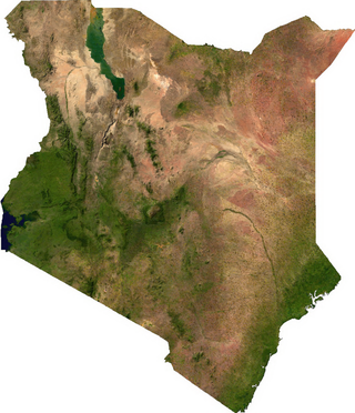
The Geography of Kenya is diverse, varying amongst its 47 counties. Kenya has a coastline on the Indian Ocean, which contains swamps of East African mangroves. Inland are broad plains and numerous hills. Kenya borders South Sudan to the northwest, Uganda to the west, Somalia to the east, Tanzania to the south, and Ethiopia to the north. Kenya currently faces border disputes with South Sudan over the Ilemi Triangle and with Somalia over Jubbaland where, if the Somalian Government gives it up, it could be a new part of Kenya, which would bring the total land area of Kenya to approximately 692,939 km2.
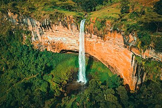
Sipi Falls is a series of three waterfalls located on the north-western slopes of the eponymous extinct volcano, Mount Elgon, in Uganda, with views over the Karamoja plains. The falls are situated to the northeast of Sironko and Mbale, adjacent to Mount Elgon National Park, which is located 1.7 kilometers away from the Kenyan border. The falls account for 10% to 20% of all tourist visits to Uganda every year.

Kitale is a town in the north west of Kenya, in the old Rift Valley province. It situated between Mount Elgon and the Cherangany Hills. The town has an elevation of around 1,900 metres (6,200 ft). Its population was 162,174 as of 2019. Kitale town is the headquarter of the Trans-Nzoia County, which is also sometimes generally referred to by the name of the town. Kitale is reachable by air through Kitale Airport. The postal code for Kitale is 30200.

Trans-Nzoia County is a county in the former Rift Valley Province, Kenya, located between the Nzoia River and Mount Elgon, 380 km northwest of Nairobi. At its centre is the town of Kitale which is the capital and largest town. It is bordered by the Republic of Uganda to the west, Bungoma and Kakamega Counties to the south, West Pokot County to the east, and Elgeyo Marakwet and Uasin Gishu Counties to the southeast. Trans Nzoia covers an area of 2495.5 square kilometres. The county has a cool and temperate climate, with daytime temperatures ranging from 23.4°C to 29.2°C and nighttime temperatures from 11.0°C to 13.5°C. It receives moderate rainfall, making it suitable for agriculture

Mount Moroto, also Moroto Mountain, is a mountain in the Northeastern part of Uganda.

Mount Elgon National Park is a national park in Kenya and Uganda that lies 140 kilometres (87 mi) northeast of Lake Victoria. The park covers an area of 1,279 square kilometres (494 sq mi). The Ugandan part of the park covers 1,110 km2 (430 sq mi) while the Kenyan part covers 169 km2 (65 sq mi). The Kenyan part of the park was gazetted in 1968, the Ugandan part in 1992.

The wildlife of Uganda is composed of its flora and fauna. Uganda has a wide variety of different habitats, including mountains, hills, tropical rainforest, woodland, freshwater lakes, swamps and savanna with scattered clumps of trees. The country has a biodiverse flora and fauna reflecting this range of habitats and is known for its primates, including gorillas and chimpanzees. There are ten national parks and thirteen wildlife reserves; some 345 species of mammal and 1020 species of bird have been recorded in the country.
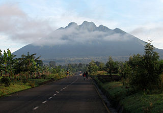
Mount Sabyinyo is an extinct volcano in eastern Africa in the Virunga Mountains. Mount Sabyinyo is the oldest volcano of the range. It is north-east of Lake Kivu, one of the African Great Lakes, and west of Lake Bunyonyi in Uganda. The summit of the mountain, at 3,669 metres (12,037 ft), marks the intersection of the borders of the Democratic Republic of the Congo (DRC), Rwanda, and Uganda, and holds religious significance for local tribes. It also is within the adjoining national parks established by these countries: Virunga National Park in the DRC, the Volcanoes National Park in Rwanda, and Mgahinga Gorilla National Park in Uganda.

The foxy cisticola is a species of bird in the family Cisticolidae.
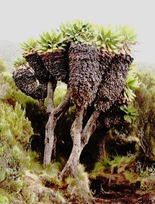
Dendrosenecio is a genus of flowering plants in the sunflower family. It is a segregate of Senecio, in which it formed the subgenus Dendrosenecio. Its members, the giant groundsels, are native to the higher altitude zones of ten mountain groups in equatorial East Africa, where they form a conspicuous element of the flora.
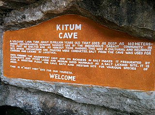
Kitum Cave is located in Mount Elgon National Park, Kenya. In the 1980s, two European visitors contracted Marburg virus disease there. It is one of five named "elephant caves" of Mount Elgon where animals, including elephants, "mine" the rock for its sodium-rich salts.

The East African montane forests is a montane tropical moist forest ecoregion of eastern Africa. The ecoregion comprises several separate areas above 2000 meters in the mountains of South Sudan, Uganda, Kenya, and Tanzania.

The East African montane moorlands is a montane grasslands and shrublands ecoregion which occupies several high mountain peaks in Kenya, South Sudan, Tanzania, and Uganda.
The Kapchorwa–Suam Road, is a rural road in the Eastern Region of Uganda. The road links Kapchorwa, the district capital of Kapchorwa District to Suam, at the international border with Kenya.
Suam, Uganda is a border crossing between Uganda and Kenya. The settlement sits directly across the Suam River from Suam, Kenya.
Suam, Kenya is a settlement in the Trans-Nzoia County of Kenya. It sits across the Suam River from Suam, Uganda, at the international border between the two countries.
The Suam–Endebess–Kitale–Eldoret Road, is a rural road in Kenya. The road links Suam, in Trans-Nzoia County, to the towns of Endebess, Kitale, and Eldoret in Uasin Gishu County.

The Sabaot are one of the nine sub-tribes of the Kalenjin of Kenya and Uganda. The Sabaot in turn are divided into six sub-tribes largely identified by their dialects. These dialects of the Sabaot language are the Pok, Somek, Mosop, Koony, Bong'omek and Sabiny. Being resident around Mount Elgon, the original homeland of most Kalenjin, the Sabaot are seen as the keepers of the authentic Kalenjin tradition. They and the area they inhabit are often referred to as Kapkugo by other Kalenjin.
Kwanza is a town in Trans-Nzoia County in western Kenya, close to the international border with Uganda. It is the headquarters of Kwanza Ward, one of the constituent wards in Kwanza Constituency.
Erica trimera is a species of flowering plant. It is a shrub or tree which grows in the mountains of eastern and central Africa.


