Related Research Articles

The Iapetus Ocean was an ocean that existed in the late Neoproterozoic and early Paleozoic eras of the geologic timescale. The Iapetus Ocean was situated in the southern hemisphere, between the paleocontinents of Laurentia, Baltica and Avalonia. The ocean disappeared with the Acadian, Caledonian and Taconic orogenies, when these three continents joined to form one big landmass called Euramerica. The "southern" Iapetus Ocean has been proposed to have closed with the Famatinian and Taconic orogenies, meaning a collision between Western Gondwana and Laurentia.

Baltica is a paleocontinent that formed in the Paleoproterozoic and now constitutes northwestern Eurasia, or Europe north of the Trans-European Suture Zone and west of the Ural Mountains. The thick core of Baltica, the East European Craton, is more than three billion years old and formed part of the Rodinia supercontinent at c. 1 Ga.
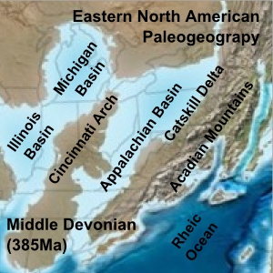
The Acadian orogeny is a long-lasting mountain building event which began in the Middle Devonian, reaching a climax in the early Late Devonian. It was active for approximately 50 million years, beginning roughly around 375 million years ago, with deformational, plutonic, and metamorphic events extending into the Early Mississippian. The Acadian orogeny is the third of the four orogenies that created the Appalachian orogen and subsequent basin. The preceding orogenies consisted of the Potomac and Taconic orogeny, which followed a rift/drift stage in the Late Neoproterozoic. The Acadian orogeny involved the collision of a series of Avalonian continental fragments with the Laurasian continent. Geographically, the Acadian orogeny extended from the Canadian Maritime provinces migrating in a southwesterly direction toward Alabama. However, the Northern Appalachian region, from New England northeastward into Gaspé region of Canada, was the most greatly affected region by the collision.
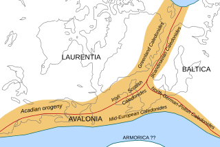
The Caledonian orogeny was a mountain-building era recorded in the northern parts of Ireland and Britain, the Scandinavian Mountains, Svalbard, eastern Greenland and parts of north-central Europe. The Caledonian orogeny encompasses events that occurred from the Ordovician to Early Devonian, roughly 490–390 million years ago (Ma). It was caused by the closure of the Iapetus Ocean when the continents and terranes of Laurentia, Baltica and Avalonia collided.
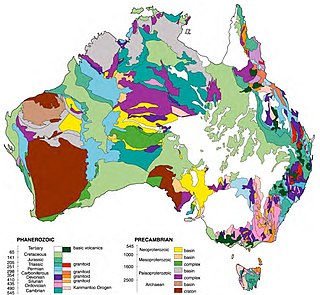
The geology of Australia includes virtually all known rock types and from all geological time periods spanning over 3.8 billion years of the Earth's history. Australia is a continent situated on the Indo-Australian Plate.

A foreland basin is a structural basin that develops adjacent and parallel to a mountain belt. Foreland basins form because the immense mass created by crustal thickening associated with the evolution of a mountain belt causes the lithosphere to bend, by a process known as lithospheric flexure. The width and depth of the foreland basin is determined by the flexural rigidity of the underlying lithosphere, and the characteristics of the mountain belt. The foreland basin receives sediment that is eroded off the adjacent mountain belt, filling with thick sedimentary successions that thin away from the mountain belt. Foreland basins represent an endmember basin type, the other being rift basins. Space for sediments is provided by loading and downflexure to form foreland basins, in contrast to rift basins, where accommodation space is generated by lithospheric extension.
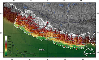
The geology of Nepal is dominated by the Himalaya, the highest, youngest and a very highly active mountain range. Himalaya is a type locality for the study of on-going continent-continent collision tectonics. The Himalayan arc extends about 2,400 km (1,500 mi) from Nanga Parbat by the Indus River in northern Pakistan eastward to Namche Barwa by the gorge of the Tsangpo-Brahmaputra in eastern Tibet. About 800 km (500 mi) of this extent is in Nepal; the remainder includes Bhutan and parts of Pakistan, India, and China.
In geology, tectonostratigraphy is stratigraphy that refers either to rock sequences in which large-scale layering is caused by the stacking of thrust sheets, or nappes, in areas of thrust tectonics or to the effects of tectonics on lithostratigraphy.
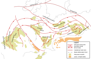
The Rhenohercynian Zone or Rheno-Hercynian zone in structural geology describes a fold belt of west and central Europe, formed during the Hercynian orogeny. The zone consists of folded and thrusted Devonian and early Carboniferous sedimentary rocks that were deposited in a back-arc basin along the southern margin of the then existing paleocontinent Laurussia.

Peter Alfred Ziegler was a Swiss geologist, who made contributions to the understanding of the geological evolution of Europe and the North Atlantic borderlands, of intraplate tectonics and of plate tectonic controls on the evolution and hydrocarbon potential of sedimentary basins. Ziegler's career consists of 33 years as exploration geologist with the petroleum industry, 30 of which with Shell, and 20 years of university teaching and research.

The Andean orogeny is an ongoing process of orogeny that began in the Early Jurassic and is responsible for the rise of the Andes mountains. The orogeny is driven by a reactivation of a long-lived subduction system along the western margin of South America. On a continental scale the Cretaceous and Oligocene were periods of re-arrangements in the orogeny. Locally the details of the nature of the orogeny varies depending on the segment and the geological period considered.

The geology of Russia, the world's largest country, which extends over much of northern Eurasia, consists of several stable cratons and sedimentary platforms bounded by orogenic (mountain) belts.
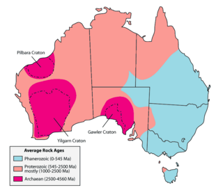
The geology of Queensland can be subdivided into several regions with different histories. Along the east coast is a complex of Palaezoic to Cainozoic rocks while much of the rest of the state is covered by Cretaceous and Cainozoic rocks. A Precambrian basement is found in the north west and Cape York regions. The Thomson Orogen occurs in the central and southern parts of Queensland, but is mostly covered by younger basins.
The Main Uralian Fault (MUF) runs north–south through the middle of the Ural Mountains for over 2,000 km. It separates both Europe from Asia and the three, or four, western megazones of the Urals from the three eastern megazones: namely the Pre-Uralian Foredeep, West Uralian, and the Central Uralian to the west, and the Tagil-Magnitogorskian, East Uralian, and Transuralian to the east. The Russian Plate is often included as the fourth megazone to the west. On the west side of the fault the rocks represent the sediments of the eastern continental margin zone of the European Plate (Baltica). On the east the rocks are accreted oceanic and island arc basalts, ultramafics and volcanics as well as the sediments of the western continental margin zones of the Siberian craton on the north and the Kazakhstan craton on the south.
The Yenisey Fold Belt is a fold belt in Russia that divides the Siberian craton from the West Siberian basin, extending about 700 kilometres (430 mi), with NW-SE strike. This belt is divided into northern and southern regions by the Angara fault which has left slip. Much of the rock was formed by Neoproterozoic accretion.
Provenance in geology, is the reconstruction of the origin of sediments. The Earth is a dynamic planet, and all rocks are subject to transition between the three main rock types: sedimentary, metamorphic, and igneous rocks. Rocks exposed to the surface are sooner or later broken down into sediments. Sediments are expected to be able to provide evidence of the erosional history of their parent source rocks. The purpose of provenance study is to restore the tectonic, paleo-geographic and paleo-climatic history.

The Famatinian orogeny is an orogeny that predates the rise of the Andes and that took place in what is now western South America during the Paleozoic, leading to the formation of the Famatinian orogen also known as the Famatinian belt. The Famatinian orogeny lasted from the Late Cambrian to at least the Late Devonian and possibly the Early Carboniferous, with orogenic activity peaking about 490 to 460 million years ago. The orogeny involved metamorphism and deformation in the crust and the eruption and intrusion of magma along a Famatinian magmatic arc that formed a chain of volcanoes. The igneous rocks of the Famatinian magmatic arc are of calc-alkaline character and include gabbros, tonalites and granodiorites. The youngest igneous rocks of the arc are granites.

The Timanide Orogen is a pre-Uralian orogen that formed in northeastern Baltica during the Neoproterozoic in the Timanide orogeny. The orogen is about 3000 km long. Its extreme points include the southern Urals in the south and the Polar Urals, the Kanin and Varanger peninsulas in the north. The Timan Ridge is the type area of the orogen. To the west, at the Varanger Peninsula, the north-west oriented Timanide Orogen is truncated by the younger Scandinavian Caledonide Orogen that has an oblique disposition. The northeastern parts of the orogen are made up of volcanic and sedimentary rocks, granitoids and few ophiolites. In contrast the southwestern part of the orogen is made up mostly of sedimentary rocks. I and A type granitoids and volcanic rocks are common in the orogen.

The Pampean orogeny was an orogeny active in the Cambrian in the western margin of the ancient landmass of Gondwana. The orogens remains can now be observed in central Argentina, in particular at the Sierras de Córdoba and other parts of the eastern Sierras Pampeanas. It is uncertain if the orogeny involved at some point a continental collision. The Pampean orogen can be considered both part of the larger Terra Australis orogen and of the Brasiliano orogeny. The Pampean orogeny was succeeded by the Famatinian orogeny further west.

The Scandinavian Caledonides are the vestiges of an ancient, today deeply eroded orogenic belt formed during the Silurian–Devonian continental collision of Baltica and Laurentia, which is referred to as the Scandian phase of the Caledonian orogeny. The size of the Scandinavian Caledonides at the time of their formation can be compared with the size of the Himalayas. The area east of the Scandinavian Caledonides, including parts of Finland, developed into a foreland basin where old rocks and surfaces were covered by sediments. Today, the Scandinavian Caledonides underlay most of the western and northern Scandinavian Peninsula, whereas other parts of the Caledonides can be traced into West and Central Europe as well as parts of Greenland and eastern North America.
References
- 1 2 Grazhdankin, D (2004). "Late Neoproterozoic sedimentation in the Timan foreland". In Gee, D.G.; Pease, V. (eds.). The Neoproterozoic Timanide Ororgen of Eastern Baltica. Geological Society, London, Memoirs. pp. 37–46.
- ↑ Roberts, D.; Olovyanishnikov, V. (2004). "Structural and tectonic development of the Timanide orogen". In Gee, D.G.; Pease, V. (eds.). The Neoproterozoic Timanide Ororgen of Eastern Baltica. Geological Society, London, Memoirs. pp. 47–57.
| This geology article is a stub. You can help Wikipedia by expanding it. |
