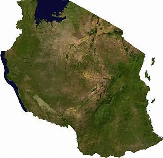
Tanzania comprises many lakes, national parks, and Africa's highest point, Mount Kilimanjaro. Northeast Tanzania is mountainous, while the central area is part of a large plateau covered in grasslands. The country also contains the southern portion of Lake Victoria on its northern border with Uganda and Kenya.

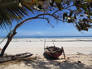
Zanzibar is an insular semi-autonomous region which united with Tanganyika in 1964 to form the United Republic of Tanzania. It is an archipelago in the Indian Ocean, 25–50 km (16–31 mi) off the coast of the African mainland, and consists of many small islands and two large ones: Unguja and Pemba Island. The capital is Zanzibar City, located on the island of Unguja. Its historic centre, Stone Town, is a World Heritage Site.

The Indo-Pacific bottlenose dolphin is a species of bottlenose dolphin. This dolphin grows to 2.6 m (8.5 ft) long, and weighs up to 230 kg (510 lb). It lives in the waters around India, northern Australia, South China, the Red Sea, and the eastern coast of Africa. Its back is dark grey and its belly is lighter grey or nearly white with grey spots.
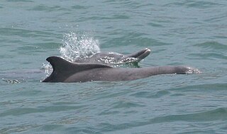
Humpback dolphins are members of the genus Sousa. These dolphins are characterized by the conspicuous humps and elongated dorsal fins found on the backs of adults of the species. Humpback dolphins inhabit shallow nearshore waters along coastlines across Australia, Africa, and Asia. Their preference for these habitats exposes them to various human activities such as fisheries entanglement, boat traffic, pollution, and habitat loss. Despite these risks, their nearshore presence facilitates easy observation from land.

The Indian Ocean humpback dolphin is a member of the Delphinidae family occupying coastal areas ranging from Southern Africa to Western Indochina. The Indo-Pacific humpback dolphin was formerly included within the same species, but a 2014 study revealed them to be a separate species.
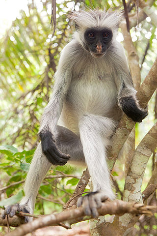
The Zanzibar red colobus is a species of red colobus monkey endemic to Unguja, the main island of the Zanzibar Archipelago, off the coast of Tanzania. It is also known as Kirk's red colobus after Sir John Kirk, the British Resident of Zanzibar who first brought it to the attention of zoological science. It is now classified as an endangered species and in the mid-1990s was adopted as the flagship species for conservation in Zanzibar. The population is still decreasing, and conservationists are attempting to work with the local government to devise a proper, effective strategy to protect the population and habitat. Challenges include the species' habitat, which is limited to the archipelago. The species has been reclassified three times; it was previously in the genus Colobus, then in the genus Procolobus, and later in the genus Piliocolobus.
Unguja North Region, Zanzibar North Region or North Zanzibar Region is one of the 31 regions of Tanzania. The region covers an area of 407 km2 (157 sq mi). The region is comparable in size to the combined land area of the nation state of Andorra. and the administrative region is located entirely on the island of Zanzibar. Unguja North Region is bordered on three sides to the north by Indian Ocean, southeast by Unguja South Region and southwest by Mjini Magharibi Region. The regional capital is the town of Mkokotoni. The region has the fifth highest HDI in the country, making one of the most developed regions in the country. According to the 2012 census, the region has a total population of 187, 455. Zanzibar North is divided into two districts, Kaskazini A and Kaskazini B.
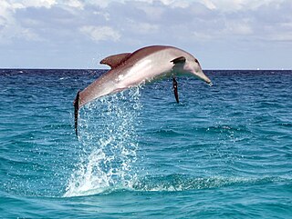
Unguja South Region, Zanzibar South Region or South Zanzibar Region is one of the 31 regions of Tanzania. The region covers an area of 854 km2 (330 sq mi). The region is comparable in size to the combined land area of the nation state of Kiribati. and the administrative region is located entirely on the island of Zanzibar. Unguja South Region is bordered on three sides to the south by Indian Ocean, northeast by Unguja North Region and northwest by Mjini Magharibi Region. The regional capital is the town of Koani. Besides being known for its Spinner dolphin populations, the region is also home to the oldest mosque in East Africa, the Kizimkazi Mosque and also historic Makunduchi town. The region has the fourth highest HDI in the country, making one of the most developed regions in the country. According to the 2022 census, the region has a total population of 195,873.
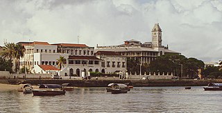
Mjini Magharibi Region, Zanzibar Urban West Region or West Zanzibar Region is one of the 31 regions of Tanzania. The region covers an area of 230 km2 (89 sq mi). The region is located entirely on the island of Zanzibar and bordered to the west by the Indian Ocean, north by Unguja North Region and the east by Unguja South Region. The region is home to one of the seven World Heritage Sites located in Tanzania, namely; Stonetown of Zanzibar. The regional capital is Zanzibar City. The region is the most developed region with the highest human development index in Tanzania at 0.718. According to the 2012 census, the region has a total population of 593,678.
Chumbe Island is a private island in the Mjini Magharibi Region, Tanzania, off the coast of Mjini District. It is situated in the Zanzibar Channel. The island is known for its ecological innovation and exceptional coral reefs. The Chumbe Lighthouse is also located on the island.

Unguja is the largest and most populated island of the Zanzibar archipelago, in Tanzania.

The Coastal forests of eastern Africa, also known as the East African Coastal Forests or Zanzibar–Inhambane forests, is a tropical moist forest region along the east coast of Africa. The region was designated a biodiversity hotspot by Conservation International.

The Jozani Chwaka Bay National Park is a 50 km2 (19 sq mi) national park in Tanzania located on the island of Zanzibar. It is the only national park in Zanzibar.

The wildlife of Zanzibar consists of terrestrial and marine flora and fauna in the archipelago of Zanzibar, an autonomous region of Tanzania. Its floral vegetation is categorized among the coastal forests of eastern Africa as the Southern Zanzibar-Inhambane coastal forest mosaic and the Northern Zanzibar-Inhambane coastal forest mosaic. Its faunal species are mostly small animals, birds, and butterflies.
The Menai Bay Conservation Area (MBCA) is located in Menai Bay, Zanzibar Tanzania. At 470 square kilometres (180 sq mi), it is Zanzibar's largest marine protected area. It was officially established as a conservation area in August 1997 in the traditional fishing area, known as Unguja Island, covering the tropical marine environment comprising extensive coral reefs, tropical fish, sea grasses, and mangrove forests. In addition to controlling illegal fishing, MBCA's alternative initiatives have included bee keeping, mangrove replanting, tree nurseries and tourism. The management of the MBCA falls upon the Fisheries Department and the bay's local villages. It is rated by the IUCN as Category VI Managed Resource Protected Area.

Kusini District is one of two administrative districts of Unguja South Region of Tanzania. The district has a water border to the east, south and west by the Indian Ocean. Kati District borders the district to the north. The district covers an area of 379.5 km2 (146.5 sq mi). The district is comparable in size to the land area of Saint Vincent and the Grenadines. The administrative seat is the historic town of Makunduchi.The district is home to the oldest mosque in use in East Africa, the historic Kizimkazi Mosque, also a National Historic Site. The district is also frequently visited by Spinner dolphins, which is one of the biggest tourism attractions in the district. According to the 2022 census, the district has a total population of 63,156.

Kwale Island is a protected island located in Fumba ward of Mjini District in Mjini Magharibi Region, Tanzania. The island is included in the marine conservation area of Menai Bay.
Miwi Island is a protected island located in Fumba ward of Mjini District in Mjini Magharibi Region, Tanzania. One of the Menai Bay islands, made of limestone, the island is a part of the Menai Bay Marine Conservation Area.
Niamembe Island is a protected island located in Fumba ward of Mjini District in Mjini Magharibi Region, Tanzania. One of the Menai Bay islands, the island is a part of the Menai Bay Marine Conservation Area and is composed of limestone.
Pungume Island is a protected island located in Fumba ward of Mjini District in Mjini Magharibi Region, Tanzania. The largest of the Menai Bay islands, the island is composed of limestone and is a part of the Menai Bay Marine Conservation Area. The island was close to the location of the 2012 capsized ship MV Sagit.

