
Gladesville Bridge is a heritage-listed concrete arch road bridge that carries Victoria Road over the Parramatta River, linking the Sydney suburbs of Huntleys Point and Drummoyne, in the local government areas of Canada Bay and Hunter's Hill, in New South Wales, Australia. Despite its name, the bridge is not in Gladesville.

The Glebe Island Bridge is a heritage-listed disused swing Allan truss road bridge that carried Victoria Road across Johnstons Bay, located in the inner city Sydney suburb of Pyrmont in the City of Sydney local government area of New South Wales, Australia. The bridge, that connected Rozelle to Pyrmont by road, is one of the last remaining swing bridges of its type in Australia and in the world. It was designed by Percy Allan and built from 1899 to 1903 by Bridges Branch of NSW Public Works Department. It is also known as RMS Bridge No. 61. It was added to the New South Wales State Heritage Register on 29 November 2013 and was listed on the Register of the National Estate on 19 April 1989.
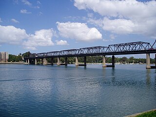
The Iron Cove Bridge is a heritage-listed road bridge that carries Victoria Road (A40) across Iron Cove, between the Sydney suburbs of Drummoyne and Rozelle. Iron Cove is an arm of Sydney Harbour.
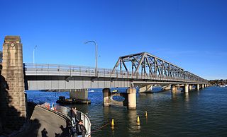
Tom Uglys Bridge are two road bridges, completed in 1929 and 1987, that carry the Princes Highway across the Georges River in southern Sydney, in the state of New South Wales, Australia. The bridges link the St George area at Blakehurst to the Sutherland Shire at Sylvania. Tom Uglys Bridge is one of six major road crossings of Georges River.

The Grafton Bridge is a heritage-listed bascule truss bridge that carries Bent Street and North Coast railway line across the Clarence River in Grafton, New South Wales, Australia. The bridge links the Grafton central business district with South Grafton, and was added to the New South Wales State Heritage Register on 2 April 1999.

The Nepean River railway bridge is a heritage-listed railway bridge that carries the Main Southern railway line across Menangle Road and the Nepean River located at the outer south-western Sydney settlement of Menangle in the Wollondilly Shire local government area of New South Wales, Australia. It was designed by John Whitton as the Engineer-in-Chief, of the New South Wales Government Railways and NSW Department of Public Works. The railway bridge was built in 1863 by Messers Peto, Brassey and Betts. It is also known as Menangle rail bridge over Nepean River and Menangle Railway Bridge. The property was added to the New South Wales State Heritage Register on 2 April 1999.

The Yowaka River bridge is a heritage-listed road bridge that carries the Princes Highway across the Yowaka River at Greigs Flat, New South Wales, Australia. It was built in 1936. The bridge is also known as the Yowaka Bridge near Eden. The bridge is owned by Transport for NSW. It was added to the New South Wales State Heritage Register on 20 June 2000.
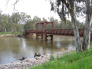
The Murray River road and railway bridge is a heritage-listed railway and former road bridge that carries the Tocumwal railway line across the Murray River at Tocumwal, New South Wales, Australia. It is also known as the Tocumwal Road and Rail Bridge over Murray River. The property is owned by the Transport Asset Holding Entity.
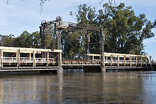
The Murray River bridge is a heritage-listed road bridge that carries Main Road across the Murray River located at Barham in the Murray River Council local government area of New South Wales, Australia. It was designed by Department of Public Works and built in 1904 by John Monash. The bridge is also known as the Barham Bridge over Murray River and the Barham bridge. The bridge is owned by the Murray River Council and was added to the New South Wales State Heritage Register on 20 June 2000.

The Murrumbidgee River bridge, Carrathool is a heritage-listed road bridge that, until its closure in 2019, carried Carrathool Road across the Murrumbidgee River in Carrathool, New South Wales, Australia. The bridge is owned by Transport for NSW. The bridge is also called the Carrathool Bridge over Murrumbidgee River and provides a key connection between the Sturt Highway and the Murrumbidgee Road. It was added to the New South Wales State Heritage Register on 20 June 2000.

The Murray River road bridge is a heritage-listed road bridge that carries Swan Hill Road across the Murray River, on the border between New South Wales and Victoria, Australia. The bridge connects Murray Downs in New South Wales with McCallum Street in Swan Hill, Victoria. The bridge was built in 1896 and is owned by Transport for NSW. The bridge is also called the Swan Hill Bridge and the Swan Hill-Murray River Road Bridge. It was added to the New South Wales State Heritage Register on 20 June 2000.
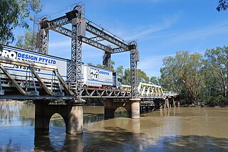
The Tooleybuc Bridge is a dual heritage-listed road bridge that carries Tooleybuc Road across the Murray River, located in Tooleybuc, New South Wales, Australia. It was built in 1925. The bridge is owned by the Transport for NSW, and is also called the Tooleybuc Bridge over Murray River. The bridge was added to the New South Wales State Heritage Register on 20 June 2000 and the Victorian Heritage Register on 10 July 2008.
The Junction Bridge is a heritage-listed road bridge that carries the Tumut Plains Road across the Tumut River, from Tumut to Tumut Plains in New South Wales, Australia. The bridge is owned by Transport for NSW. It was added to the New South Wales State Heritage Register on 20 June 2000.

The Williams River bridge, Clarence Town is a heritage-listed road bridge that carries Limeburners Creek Road across the Williams River located in Clarence Town, New South Wales, Australia. It was designed by the New South Wales Public Works Department and built by J. K. McKenzie. The property is owned by Transport for NSW. It was added to the New South Wales State Heritage Register on 20 June 2000.

The Manning River railway bridge is a heritage-listed railway bridge that carries the North Coast Line across the Manning River located at Mount George, near Taree in the Mid-Coast Council local government area of New South Wales, Australia. The bridge is also known as the Mount George Rail Bridge over Manning River. The property is owned by Transport Asset Holding Entity, an agency of the Government of New South Wales. It was added to the New South Wales State Heritage Register on 2 April 1999.
The Manilla railway underbridges are two heritage-listed railway bridges located on the Tamworth-Barraba railway line in the town of Manilla in the Tamworth Regional Council local government area of New South Wales, Australia. The underbridges are owned by Transport Asset Holding Entity, an agency of the Government of New South Wales. The two sites were added to the New South Wales State Heritage Register on 2 April 1999.

The Dunmore Bridge is a heritage-listed road bridge that carries Clarence Town Road across the Paterson River in Woodville, New South Wales, Australia. It was designed by Percy Allan and built in 1899 by Morpeth contractor, S. McGill. The property is owned by Transport for NSW. It was added to the New South Wales State Heritage Register on 20 June 2000.

The Tunks Creek Bridge is a heritage-listed timber truss road bridge that carries Galston Road across Tunks Creek, in Galston, New South Wales, Australia. The bridge spans Tunks Creek in the valley of the Galston Gorge. The road through the gorge provides a link between Hornsby Heights and Galston, suburbs of Sydney. The bridge is also known as the Bridge over Tunks (Pearces) Creek and Pearces Creek Bridge. The bridge is owned by Transport for NSW. It was added to the New South Wales State Heritage Register on 20 June 2000.
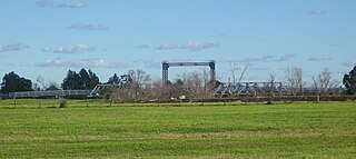
The Hinton Bridge over Paterson River is a heritage-listed road bridge that carrier the Hinton-Morpeth Road across the Paterson River at Hinton, New South Wales, Australia. The bridge was designed by Ernest de Burgh and built in 1901. The bridge is owned by Transport for NSW. The bridge was added to the New South Wales State Heritage Register on 20 June 2000.

The MacDonald River bridge is a heritage-listed road bridge that carries St Albans Road across the MacDonald River at St Albans, New South Wales, Australia. It was designed by Ernest de Burgh and built by John Ahearn and Son. It is also known as Norton Bridge. The property is owned by Transport for NSW. It was added to the New South Wales State Heritage Register on 20 June 2000.


