
Southington is a town in Hartford County, Connecticut, United States. The town is part of the Capitol Planning Region. As of the 2020 United States Census, it had a population of 43,501. Southington contains the villages of Marion, Milldale, and Plantsville.

Seaforth is a Southern Ontario community in the municipality of Huron East, in Huron County, Ontario, Canada.

Chatsworth is a township municipality in Grey County, in southwestern Ontario, Canada. The township is located at the headwaters of the Styx River, the Saugeen River, the Sauble River, the Bighead River, the Spey River, and the old Sydenham River.

Tweed is a municipality located in central-eastern Ontario, Canada, in Hastings County.

St. Marys is a town in southwestern Ontario, Canada. It is located at the confluence of the north branch of the Thames River and Trout Creek southwest of Stratford, and is surrounded by the Township of Perth South in Perth County, Ontario. St. Marys operates under its own municipal government that is independent from the county's government. Nonetheless, the three entities "enjoy a large degree of collaboration and work together to grow the region as a leading location for industry and people". Census data published for Perth County by Statistics Canada includes St. Marys and most Perth County publications also do, at least in some sections of the document.
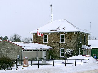
Tweed, Ontario is a community on Stoco Lake and the only urban centre of the Municipality of Tweed in Hastings County, central-eastern Ontario, Canada. It had a population of 1,701 in the 2016 census. The principal thoroughfare is Highway 37.
Elizabethtown-Kitley is a township in eastern Ontario, Canada, in the United Counties of Leeds and Grenville. Its southern border lies along the St. Lawrence River and it extends north into many rural hamlets and villages. The township was created on January 1, 2001, by the amalgamation of the former Township of Elizabethtown and Township of Kitley.

Aultsville is a ghost town in the Canadian province of Ontario. It is one of Ontario's Lost Villages, which were permanently flooded by the creation of the St. Lawrence Seaway in 1958. The town was founded as Charlesville in 1787 by United Empire Loyalists and reached its peak in 1880, when it had 400 residents. It was the second largest town flooded by the new Seaway in 1958, with a population of 312 at the time. Before it was flooded, the abandoned buildings were burned to study the effects of fire on houses.
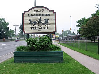
Clarkson, also called Clarkson Village, is a neighbourhood in the city of Mississauga, Ontario, Canada, situated in the southwest corner of the city, along the shore of Lake Ontario. It is bordered by Lake Ontario to the south, Oakville to the west, Erindale and Erin Mills to the north, and Lorne Park to the east.

Lewistown is an unincorporated community and census-designated place (CDP) in central Washington Township, Logan County, Ohio, United States. As of the 2020 census, the population was 202.
Edwardsburgh/Cardinal is a township in the United Counties of Leeds and Grenville of eastern Ontario, Canada. Edwardsburgh township was first surveyed in 1783, and incorporated in 1850. The township was part of the historical Grenville County before it merged with Leeds County to form the United Counties in the 19th century.

The Royal Ordnance Factory (ROF) Bishopton was a WW2 Ministry of Supply Explosive Factory. It is sited adjacent to the village of Bishopton in Renfrewshire, Scotland. The factory was built to manufacture the propellant cordite for the British Army and the Royal Air Force. It also later produced cordite for the Royal Navy. The Ministry of Works were responsible for the site. It was the biggest munitions factory the MOD had, with up to 20,000 workers.

Grafton is a community in the province of Ontario. It is an example of the type of hamlets that flourished in the 19th century.

The Miller Tavern is a restaurant located in a historic building at 3885 Yonge Street in Toronto, Ontario, south of York Mills Road in the York Mills neighbourhood. Originally called the York Mills Hotel and later named the Jolly Miller, the building dates from the 1850s.
King's Highway 37, commonly referred to as Highway 37, is a provincially maintained highway in the Canadian province of Ontario. It begins at Highway 401 in Belleville and travels 44.2 km (27.5 mi) north to Highway 7 in Actinolite. The route once continued south through Belleville to Highway 62, but was truncated in 1998. Prior to the re-routing, Highway 37 was 47.2 km (29.3 mi) long.

Stone Mills is a lower-tier township north of Greater Napanee in Lennox and Addington County, Ontario, Canada. According to the 2016 census, the township has a population of 7,702.
Redditt is an unincorporated community in Unorganized Kenora District in northwestern Ontario, Canada. It is on the MacFarlane River, and located at the northern terminus of Ontario Highway 658, 27 kilometres (17 mi) north of Kenora. Redditt is also the name of the surrounding geographic township that includes the community.
Athens is a small unincorporated village in Fayette County to the east of Interstate 75 in Kentucky in the United States.

Demorestville is a small village in Sophiasburgh Township in Prince Edward County, Ontario, Canada. It was named after Guilliame Demorest. Once much larger, it currently has a population of approximately one hundred. A formerly much larger creek which once powered mills fed by Fish Lake, flows through the center of town and has now been protected under the Demorestville Conservation Area.
The Phoenix Hotel was one of the most popular social spots in Dedham during the 19th century. It was located on the northwest corner of the High Street-Washington Street intersection in modern-day Dedham Square. Among the distinguished guests of this hotel were Andrew Jackson and James Monroe.