A Geographic Information System (GIS) is a system designed to capture, store, manipulate, analyze, manage, and present spatial or geographic data. GIS applications are tools that allow users to create interactive queries, analyze spatial information, edit data in maps, and present the results of all these operations. GIS sometimes refers to geographic information science (GIScience), the science underlying geographic concepts, applications, and systems. Since the mid-1980s, geographic information systems have become valuable tool used to support a variety of city and regional planning functions.

Esri is an international supplier of geographic information system (GIS) software, web GIS and geodatabase management applications. The company is headquartered in Redlands, California.

Geographic Resources Analysis Support System is a geographic information system (GIS) software suite used for geospatial data management and analysis, image processing, producing graphics and maps, spatial and temporal modeling, and visualizing. It can handle raster, topological vector, image processing, and graphic data.
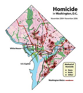
Crime mapping is used by analysts in law enforcement agencies to map, visualize, and analyze crime incident patterns. It is a key component of crime analysis and the CompStat policing strategy. Mapping crime, using Geographic Information Systems (GIS), allows crime analysts to identify crime hot spots, along with other trends and patterns.
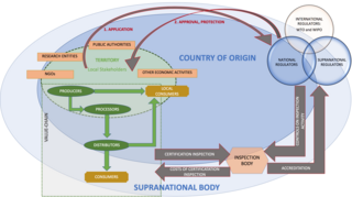
A geographical indication (GI) is a name or sign used on products which corresponds to a specific geographical location or origin. The use of a geographical indication, as a type of indication of source, acts as a certification that the product possesses certain qualities, is made according to traditional methods, or enjoys a certain reputation, due to its geographical origin.

The elevation of a geographic location is its height above or below a fixed reference point, most commonly a reference geoid, a mathematical model of the Earth's sea level as an equipotential gravitational surface . The term elevation is mainly used when referring to points on the Earth's surface, while altitude or geopotential height is used for points above the surface, such as an aircraft in flight or a spacecraft in orbit, and depth is used for points below the surface.
A Web Map Service (WMS) is a standard protocol developed by the Open Geospatial Consortium in 1999 for serving georeferenced map images over the Internet. These images are typically produced by a map server from data provided by a GIS database.

ArcGIS is a geographic information system (GIS) for working with maps and geographic information. It is used for creating and using maps, compiling geographic data, analyzing mapped information, sharing and discovering geographic information, using maps and geographic information in a range of applications, and managing geographic information in a database.
Simple Features is both an Open Geospatial Consortium (OGC) and International Organization for Standardization (ISO) standard ISO 19125 that specifies a common storage and access model of mostly two-dimensional geometries used by geographic information systems.

QGIS is a free and open-source cross-platform desktop geographic information system (GIS) application that supports viewing, editing, and analysis of geospatial data.
The Indian Institute of Remote Sensing is a premier institute for research, higher education and training in the field of Remote Sensing, Geoinformatics and GPS Technology for Natural Resources, Environmental and Disaster Management under the Indian Department of Space, which was established in the year 1966. It is located in the city of Dehradun, Uttarakhand.
Geospatial metadata is a type of metadata that is applicable to objects that have an explicit or implicit geographic extent, i.e. are associated with some position on the surface of the globe. Such objects may be stored in a geographic information system (GIS) or may simply be documents, data-sets, images or other objects, services, or related items that exist in some other native environment but whose features may be appropriate to describe in a (geographic) metadata catalog.
The Great Britain Historical GIS, is a spatially enabled database that documents and visualises the changing human geography of the British Isles, although is primarily focussed on the subdivisions of the United Kingdom mainly over the 200 years since the first census in 1801. The project is currently based at the University of Portsmouth, and is the provider of the website A Vision of Britain through Time.

Geographic Information Systems (GIS) has become an integral part of aquatic science and limnology. Water by its very nature is dynamic. Features associated with water are thus ever-changing. To be able to keep up with these changes, technological advancements have given scientists methods to enhance all aspects of scientific investigation, from satellite tracking of wildlife to computer mapping of habitats. Agencies like the US Geological Survey, US Fish and Wildlife Service as well as other federal and state agencies are utilizing GIS to aid in their conservation efforts.
Gis Gelati was an Italian professional cycling team that was active between 1978 and 1991. It had headquarters in Giulianova Small town in Abruzzo.

Global Investors Summit, officially the Invest Madhya Pradesh Global Investors Summit or GIS is a biennial business summit organized by Government of Madhya Pradesh in Indore, the commercial capital of central India to attract domestic and foreign investment for development of the state. Based on the theme– India's Growth Centre and aimed at bringing together business leaders, investors, corporations, thought leaders, policy and opinion makers; the summit serves as a perfect platform to understand and explore business opportunities in the State of Madhya Pradesh.
U.S. soldiers were reported committing rape against French women during and after the liberation of France in the later stages of World War II. The sociologist J. Robert Lilly of Northern Kentucky University estimates that U.S. servicemen committed around 3,500 rapes in France between June 1944 and the end of the war.
GIS United is union of GIS specialists who have variety of backgrounds such as business administration, public administration, environmental engineering, mechanical engineering, statistics, urban engineering, architecture, historical studies, literature, art etc. As a consulting firm to analyze Geo-spatial Big Data specializes headquartered in Mapo Seogyo, Seoul, South Korea.

