
U.S. Route 1 or U.S. Highway 1 (US 1) is a major north–south United States Numbered Highway that serves the East Coast of the United States. It runs 2,370 miles (3,810 km) from Key West, Florida, north to Fort Kent, Maine, at the Canadian border, making it the longest north–south road in the United States. US 1 is generally paralleled by Interstate 95 (I-95), though US 1 is significantly farther west and inland between Jacksonville, Florida, and Petersburg, Virginia, while I-95 is closer to the coastline. In contrast, US 1 in Maine is much closer to the coast than I-95, which runs farther inland than US 1. The route connects most of the major cities of the East Coast from the Southeastern United States to New England, including Miami, Jacksonville, Augusta, Raleigh, Richmond, Washington, D.C., Baltimore, Philadelphia, Newark, New York City, New Haven, Providence, Boston, and Portland.
U.S. Route 2 or U.S. Highway 2 (US 2) is an east–west United States Numbered Highway spanning 2,571 miles (4,138 km) across the northern continental United States. US 2 consists of two segments connected by various roadways in southern Canada. Unlike some routes, which are disconnected into segments because of encroaching Interstate Highways, the two portions of US 2 were designed to be separate in the original 1926 highway plan.
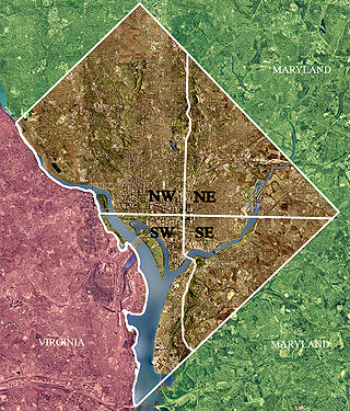
Southwest is the southwestern quadrant of Washington, D.C., the capital of the United States, and is located south of the National Mall and west of South Capitol Street. It is the smallest quadrant of the city, and contains a small number of named neighborhoods and districts, including Bellevue, Southwest Federal Center, the Southwest Waterfront, Buzzard Point, and the military installation known as Joint Base Anacostia–Bolling.

L'Enfant Plaza is a complex of four commercial buildings grouped around a large plaza in the Southwest section of Washington, D.C., United States. Immediately below the plaza and the buildings is La Promenade shopping mall.

Interstate 295 (I-295) also known as the Anacostia Freeway, is a six-mile (9.7 km) auxiliary Interstate Highway in the US state of Maryland and in Washington, D.C.. It connects I-95/I-495 and Maryland Route 210 near the Potomac River to I-695 and District of Columbia Route 295 (DC 295) in the Anacostia neighborhood of Washington, D.C.
Interstate 395 (I-395) in Virginia and Washington, D.C., is a 13.79-mile-long (22.19 km) spur route of I-95 that begins at an interchange with I-95 in Springfield and ends at an interchange with US Route 50 (US 50) in Northwest Washington, D.C. It passes underneath the National Mall near the US Capitol and ends at a junction with US 50 at New York Avenue, roughly one mile (1.6 km) north of the 3rd Street Tunnel. Despite its proximity to I-395 in Maryland, the route is unrelated and unconnected.
Interstate 695 (I-695), also known as the Southeast Freeway, is a two-mile-long (3.2 km) auxiliary Interstate Highway in Washington, D.C.. It travels from an interchange with I-395 south of the US Capitol building east then south across the 11th Street Bridges to an intersection with I-295 and District of Columbia Route 295 (DC 295) in Anacostia.

Massachusetts Avenue is a major diagonal transverse road in Washington, D.C., and the Massachusetts Avenue Historic District is a historic district that includes part of it.

Independence Avenue is a major east-west street in the southwest and southeast quadrants of the city of Washington, D.C., in the United States, running just south of the United States Capitol. Originally named South B Street, Independence Avenue SW was constructed between 1791 and 1823. Independence Avenue SE was constructed in pieces as residential development occurred east of the United States Capitol and east of the Anacostia River.

South Capitol Street is a major street dividing the southeast and southwest quadrants of Washington, D.C., in the United States. It runs south from the United States Capitol to the D.C.–Maryland line, intersecting with Southern Avenue. After it enters Maryland, the street becomes Indian Head Highway at the Eastover Shopping Center, a terminal or transfer point of many bus routes.

The name "M Street" refers to two major roads in the United States capital of Washington, D.C. Because of the Cartesian coordinate system used to name streets in Washington, the name "M Street" can be used to refer to any east–west street located twelve blocks north or south of the dome of the United States Capitol. Thus, in all four quadrants of the city there are streets called "M Street", which are disambiguated by quadrant designations, namely, M Street NW, NE, SW, and SE.

The 11th Street Bridges are a complex of three bridges across the Anacostia River in Washington, D.C., United States. The bridges convey Interstate 695 across the Anacostia to its southern terminus at Interstate 295 and DC 295. The bridges also connect the neighborhood of Anacostia with the rest of the city of Washington.
The Inner Loop was two planned freeways around downtown Washington, D.C. The innermost loop would have formed an oval centered on the White House, with a central freeway connecting the southern segment to the northern segment and then continuing on to Interstate 95. Interstate 95 would have met Interstate 66, Interstate 295, Interstate 695, and US 50 while traversing the Inner Loop. A second loop was an arc across the northern section of the city, beginning at East Capitol Street at the Anacostia River and using the Missouri Avenue NW and Nebraska Avenue NW commercial corridors to terminate in Georgetown.
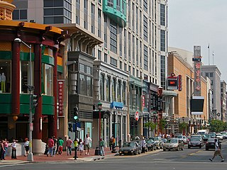
There are two north–south arteries in Washington, D.C. named 7th Street that are differentiated by the quadrants of the city in which they are located.

The Maine Avenue Fish Market, also known as the Municipal Fish Market, the Fish Wharf, or simply, the Wharf, is an open-air seafood market in Southwest Washington, D.C., a local landmark and one of the few that remain on the east coast of the United States. It is the oldest continuously operating fish market in the United States, founded 17 years earlier than New York City's Fulton Fish Market.
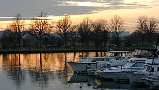
The Washington Channel is a channel parallel to the Potomac River in Washington, D.C. It is located between the Southwest Waterfront on the east side and East Potomac Park on the west side. The channel is two miles (3.2 km) long, receives outflow from the Tidal Basin at its north end, and empties into the Anacostia River at Hains Point at its south end. The channel's depth ranges from 8.8 feet (2.7 m) to 23 feet (7.0 m).

The Southwest Waterfront is a neighborhood in Southwest Washington, D.C. The Southwest quadrant is the smallest of Washington's four quadrants, and the Southwest Waterfront is one of only two residential neighborhoods in the quadrant; the other is Bellevue, which, being east of the Anacostia River, is frequently, if mistakenly, regarded as being in Southeast.

Southwest Federal Center is a business district in Southwest Washington, D.C., nearly entirely occupied by offices for various branches of the U.S. Government, including many of the museums of the Smithsonian Institution.

The Anacostia Riverwalk Trail is a multi-use trail system in Washington, DC, which, when complete, will be ~25 miles long, spanning both sides of the Anacostia River, the Washington Channel waterfront, and projecting into neighborhoods away from the Anacostia. It has more recently been branded as part of a larger Anacostia Riverwalk Trail Network which includes an additional 8 segments and 15 miles of trail. On the north end it connects to the Anacostia Tributary Trail System; on the south end it will connect to the Oxon Hill Farm Trail and on the west it connects to the Rock Creek Park Trail and the 14th Street Bridge. Of the 19 planned segments, 14 are complete for a combined total of 16 miles.

The Convention Center–Southwest Waterfront Line, designated as Route 74, is a daily bus route that is operated by the Washington Metropolitan Area Transit Authority between Walter E. Washington Convention Center and Buzzard Point via 7th Street NW/SW. The line operates every 30 minutes at all times. Trips are roughly 20–30 minutes. This line provides service via Downtown connecting major arenas, the National Mall, and landmarks without having to enter by train. It is a replacement for Metrobus Routes 70 and 71 and the DC Circulator's Convention Center-Southwest Waterfront route.


