
Lyons is a Statutory Town in Boulder County, Colorado, United States. The town population was 2,209 at the 2020 United States Census, up from 2,033 at the 2010 United States Census. Lyons is located at the confluence of North St. Vrain Creek and South St. Vrain Creek, 20 miles (32 km) east of Rocky Mountain National Park. Due to its location at the intersection of State Highway 7 and U.S. Highway 36 which lead to Rocky Mountain National Park, it is sometimes referred to as "The Double Gateway to the Rockies".

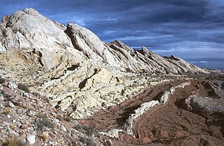
The Entrada Sandstone is a formation in the San Rafael Group found in the U.S. states of Wyoming, Colorado, northwest New Mexico, northeast Arizona, and southeast Utah. Part of the Colorado Plateau, this formation was deposited during the Jurassic Period sometime between 180 and 140 million years ago in various environments, including tidal mudflats, beaches, and sand dunes. The Middle Jurassic San Rafael Group was dominantly deposited as ergs in a desert environment around the shallow Sundance Sea.
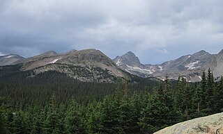
The Front Range is a mountain range of the Southern Rocky Mountains of North America located in the central portion of the U.S. State of Colorado, and southeastern portion of the U.S. State of Wyoming. It is the first mountain range encountered as one goes westbound along the 40th parallel north across the Great Plains of North America.
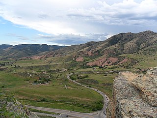
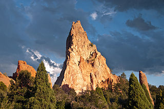
Red Rocks Park is a mountain park in Jefferson County, Colorado, owned and maintained by the city of Denver as part of the Denver Mountain Parks system. The park is known for its very large red sandstone outcrops. Many of these rock formations within the park have names, from the mushroom-shaped Seat of Pluto to the inclined Cave of the Seven Ladders. The most visited rocks, around Red Rocks Amphitheatre, are Creation Rock to the north, Ship Rock to the south, and Stage Rock to the east.

The geology of the Grand Canyon area includes one of the most complete and studied sequences of rock on Earth. The nearly 40 major sedimentary rock layers exposed in the Grand Canyon and in the Grand Canyon National Park area range in age from about 200 million to nearly 2 billion years old. Most were deposited in warm, shallow seas and near ancient, long-gone sea shores in western North America. Both marine and terrestrial sediments are represented, including lithified sand dunes from an extinct desert. There are at least 14 known unconformities in the geologic record found in the Grand Canyon.
The Colorado Piedmont is an area along the base of the foothills of the Front Range in north central Colorado in the United States. The region consists of a broad hilly valley, just under 5000 ft in elevation, stretching north and northeast from Denver in the valley of the South Platte River, as well as along the Arkansas River valley southward from Colorado Springs. The name Colorado Piedmont also refers to the physiographic section of the Great Plains province.

The Denver Basin, variously referred to as the Julesburg Basin, Denver-Julesburg Basin, or the D-J Basin, is a geologic structural basin centered in eastern Colorado in the United States, but extending into southeast Wyoming, western Nebraska, and western Kansas. It underlies the Denver-Aurora Metropolitan Area on the eastern side of the Rocky Mountains.
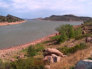
Horsetooth Reservoir is a large reservoir in southern Larimer County, Colorado, in the foothills just west of the city of Fort Collins, Colorado. The reservoir runs north-south for approximately 6.5 miles (10 km) and is approximately one-half mile (1 km) wide. Its shape and orientation are the result of the fact that the main body of the reservoir is contained between several homoclinal ridges. A ridge composed of Dakota sandstone runs along the east side where gaps in the ridge are plugged by dams. On the west (uphill) side there are two prominent ridges topped by erosion-resistant sandstones of the Lyons and Ingleside formations. Gaps in these ridges have created a handful of bays and coves the largest of which is Inlet Bay, home to a marina and campgrounds.

The Flatirons are rock formations in the western United States, near Boulder, Colorado, consisting of flatirons. There are five large, numbered Flatirons ranging from north to south along the east slope of Green Mountain, and the term "The Flatirons" sometimes refers to these five alone. Numerous additional named Flatirons are on the southern part of Green Mountain, Bear Peak, and among the surrounding foothills.
The Navajo Sandstone is a geological formation in the Glen Canyon Group that is spread across the U.S. states of southern Nevada, northern Arizona, northwest Colorado, and Utah as part of the Colorado Plateau province of the United States.
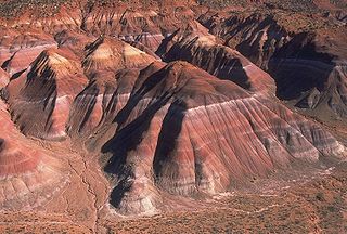
The Chinle Formation is an Upper Triassic continental geological formation of fluvial, lacustrine, and palustrine to eolian deposits spread across the U.S. states of Nevada, Utah, northern Arizona, western New Mexico, and western Colorado. In New Mexico, it is often raised to the status of a geological group, the Chinle Group. Some authors have controversially considered the Chinle to be synonymous to the Dockum Group of eastern Colorado and New Mexico, western Texas, the Oklahoma panhandle, and southwestern Kansas. The Chinle Formation is part of the Colorado Plateau, Basin and Range, and the southern section of the Interior Plains. A probable separate depositional basin within the Chinle is found in northwestern Colorado and northeastern Utah. The southern portion of the Chinle reaches a maximum thickness of a little over 520 meters (1,710 ft). Typically, the Chinle rests unconformably on the Moenkopi Formation.

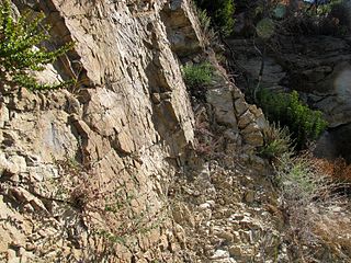
The Fountain Formation is a Pennsylvanian bedrock unit consisting primarily of conglomerate, sandstone, or arkose, in the states of Colorado and Wyoming in the United States, along the east side of the Front Range of the Rocky Mountains, and along the west edge of the Denver Basin.
The Laramie Formation is a geologic formation of the Late Cretaceous (Maastrichtian) age, named by Clarence King in 1876 for exposures in northeastern Colorado, in the United States. It was deposited on a coastal plain and in coastal swamps that flanked the Western Interior Seaway. It contains coal, clay and uranium deposits, as well as plant and animal fossils, including dinosaur remains.
The Kaiparowits Plateau is a large, elevated landform located in southern Utah, in the southwestern United States. Along with the Grand Staircase and the Canyons of the Escalante, it makes up a significant portion of the Grand Staircase–Escalante National Monument. Its extension to the southeast, Fiftymile Mountain, runs nearly to the Colorado River and Lake Powell, and is a prominent part of the northern skyline from the Glen Canyon National Recreation Area.
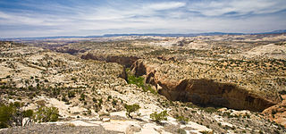
The Canyons of the Escalante is a collective name for the erosional landforms created by the Escalante River and its tributaries—the Escalante River Basin. Located in southern Utah in the western United States, these sandstone features include high vertical canyon walls, numerous slot canyons, waterpockets, domes, hoodoos, natural arches and bridges. This area—extending over 1,500 square miles (3,885 km2) and rising in elevation from 3,600 ft (1,097 m) to over 11,000 ft (3,353 m)—is one of the three main sections of the Grand Staircase–Escalante National Monument, and also a part of the Glen Canyon National Recreation Area, with Capitol Reef National Park being adjacent to the east.

Dinosaur Ridge is a segment of the Dakota Hogback in the Morrison Fossil Area National Natural Landmark located in Jefferson County, Colorado, near the town of Morrison and just west of Denver.
Prehistory of Colorado provides an overview of the activities that occurred prior to Colorado's recorded history. Colorado experienced cataclysmic geological events over billions of years, which shaped the land and resulted in diverse ecosystems. The ecosystems included several ice ages, tropical oceans, and a massive volcanic eruption. Then, ancient layers of earth rose to become the Rocky Mountains.
The Matilija Sandstone is a sedimentary geologic unit of Eocene epoch in the Paleogene Period, found in Santa Barbara and Ventura Counties in Southern California.

The Benton Shale is a geologic formation name historically used in Montana, Wyoming, North Dakota, South Dakota, Colorado, Kansas, and Nebraska. In the "mile high" plains in the center of the continent, the named layers preserve marine fossils from the Late Cretaceous Period. The term Benton Limestone has also been used to refer to the chalky portions of the strata, especially the beds of the strata presently classified as Greenhorn Limestone, particularly the Fencepost limestone.
The bedrock under the U.S. State of Colorado was assembled from island arcs accreted onto the edge of the ancient Wyoming Craton. The Sonoma orogeny uplifted the ancestral Rocky Mountains in parallel with the diversification of multicellular life. Shallow seas covered the regions, followed by the uplift current Rocky Mountains and intense volcanic activity. Colorado has thick sedimentary sequences with oil, gas and coal deposits, as well as base metals and other minerals.
