The geography of Argentina is heavily diverse, consisting of the Andes Mountains, pampas, and various rivers and lakes. Bordered by the Andes in the west and the South Atlantic Ocean to the east, its neighbouring countries are Chile to the west, Bolivia and Paraguay to the north, and Brazil and Uruguay to the northeast.

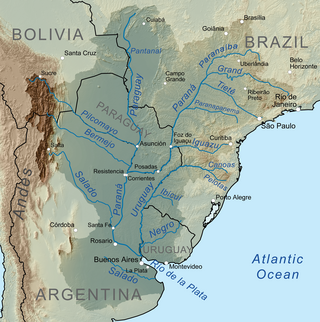
The Río de la Plata, also called the River Plate or La Plata River in English, is the estuary formed by the confluence of the Uruguay River and the Paraná River at Punta Gorda. It empties into the Atlantic Ocean and forms a funnel-shaped indentation on the southeastern coastline of South America. Depending on the geographer, the Río de la Plata may be considered a river, an estuary, a gulf, or a marginal sea. If considered a river, it is the widest in the world, with a maximum width of 220 kilometres (140 mi).
Cerro is Spanish for "hill" or "mountain".

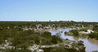
The Bermejo River is a river in South America that flows from Bolivia to the Paraguay River in Argentina. The river is generally called Bermejo in spite of its different names along its way, but it also has its own Native American names; in Wichí it is called Teuco, and in Guaraní it is called Ypitá. In the plains of Argentina's Gran Chaco the Bermejo forms wetlands and splits into two branches. The southern branch is the bed of the old Bermejo River, now an intermittent stream called Río Bermejito. The northern branch is now the main stem of the Bermejo and is called the Teuco River, Bermejo Nuevo, or simply the Bermejo River. The two branches rejoin at 25°39′S60°11′W, near Villa Río Bermejito, forming the Lower Bermejo River.

Departments form the second level of administrative division, and are subdivided in municipalities. They are extended in all of Argentina except for the Province of Buenos Aires and the Autonomous City of Buenos Aires, the national capital, each of which has different administrative arrangements.

The Salado River is a river that crosses several provinces of Argentina, flowing 1,150 kilometres (710 mi) from its source in the Salta Province to end in the Paraná River, in the Santa Fe Province. Because of its origin, its flow varies widely within the year, and it can dry out in some parts of its path during the winter. The only important tributary to the river is the Horcones River, which is born in Salta as Cajón River, and joins the Salado in the Santiago del Estero Province.

The following is an alphabetical list of topics related to the Argentina.

The Desaguadero River is a river in Argentina. Originating near the Tipas volcano in La Rioja at about 5,500 m (18,000 ft) elevation, the river is known in its upper reaches as the Bermejo or Vinchina. In its lower reaches, it is also known as the Salado. It joins the Colorado River in La Pampa Province near Pichi Mahuida. The Desaguadero has a total length of 1,498 km (931 mi) and its drainage basin is about 260,000 km2 (100,000 sq mi).

The Río de la Plata basin, more often called the River Plate basin in scholarly writings, sometimes called the Platine basin or Platine region, is the 3,170,000-square-kilometre (1,220,000 sq mi) hydrographical area in South America that drains to the Río de la Plata. It includes areas of southeastern Bolivia, southern and central Brazil, the entire country of Paraguay, most of Uruguay, and northern Argentina. Making up about one fourth of the continent's surface, it is the second largest drainage basin in South America and one of the largest in the world.
The Litoral region of Argentina underwent heavy rainstorms in the early autumn season of 2007. Starting in late March and ending in mid-April, the rains caused several major rivers to rise and/or overflow their banks, partly or completely flooded many towns and large cities, ruined a significant part of the crops in a wide region, and severely damaged the physical infrastructure. At least 15 people were killed as a result of the flooding.
Salado River or Río Salado may refer to:
Chico River may refer to:


