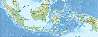
Indonesia is an archipelagic country located in Southeast Asia and Oceania, lying between the Indian Ocean and the Pacific Ocean. It is located in a strategic location astride or along major sea lanes connecting East Asia, South Asia and Oceania. Indonesia is the largest archipelago in the world. Indonesia's various regional cultures have been shaped—although not specifically determined—by centuries of complex interactions with its physical environment.

The South China Sea is a marginal sea of the Western Pacific Ocean. It is bounded in the north by South China, in the west by the Indochinese Peninsula, in the east by the islands of Taiwan and northwestern Philippines, and in the south by Borneo, eastern Sumatra and the Bangka Belitung Islands, encompassing an area of around 3,500,000 km2 (1,400,000 sq mi). It communicates with the East China Sea via the Taiwan Strait, the Philippine Sea via the Luzon Strait, the Sulu Sea via the straits around Palawan, and the Java Sea via the Karimata and Bangka Straits. The Gulf of Thailand and the Gulf of Tonkin are part of the South China Sea.

The Sulu Sea is a body of water in the southwestern area of the Philippines, separated from the South China Sea in the northwest by Palawan and from the Celebes Sea in the southeast by the Sulu Archipelago. Borneo is found to the southwest and Visayas to the northeast.

The Sunda Islands are a group of islands in the Indonesian Archipelago. They consist of the Greater Sunda Islands and the Lesser Sunda Islands.
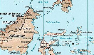
The Celebes Sea or Sulawesi Sea of the western Pacific Ocean is bordered on the north by the Sulu Archipelago and Sulu Sea and Mindanao Island of the Philippines, on the east by the Sangihe Islands chain, on the south by Sulawesi's Minahasa Peninsula, and the west by northern Kalimantan in Indonesia. It extends 420 miles (675 km) north-south by 520 mi (840 km) east-west and has a total surface area of 110,000 square miles (280,000 km2), to a maximum depth of 20,300 feet (6,200 m). South of the Cape Mangkalihat, the sea opens southwest through the Makassar Strait into the Java Sea.
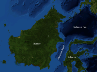
Makassar Strait is a strait between the islands of Borneo and Sulawesi in Indonesia. To the north it joins the Celebes Sea, while to the south it meets the Java Sea. To the northeast, it forms the Sangkulirang Bay south of the Mangkalihat Peninsula. The strait is an important regional shipping route in Southeast Asia.

Sundaland is a biogeographical region of Southeast Asia corresponding to a larger landmass that was exposed throughout the last 2.6 million years during periods when sea levels were lower. It includes Bali, Borneo, Java, and Sumatra in Indonesia, and their surrounding small islands, as well as the Malay Peninsula on the Asian mainland.

The Timor Sea is a relatively shallow sea in the Indian Ocean bounded to the north by the island of Timor with Timor-Leste to the north, Indonesia to the northwest, Arafura Sea to the east, and to the south by Australia. The Sunda Trench marks the deepest point of the Timor Sea with a depth of more than 3300 metres, separating the continents of Oceania in the southeast and Asia to the northwest and north. The Timor sea is prone to earthquakes and tsunamis north of the Sunda Trench, due to its location on the Ring of Fire as well as volcanic activity and can experience major cyclones, due to the proximity from the Equator.

The Savu Sea is a small sea within Indonesia named for the island of Savu (Sawu) on its southern boundary. It is bounded by Savu and Raijua to the south, the islands of Rote and Timor to the east, Flores and the Alor archipelago to the north/northwest, and the island of Sumba to the west/northwest. Between these islands, it flows into the Indian Ocean to the south and west, the Flores Sea to the north, and the Banda Sea to the northeast.

The Banda Sea is one of four seas that surround the Maluku Islands of Indonesia, connected to the Pacific Ocean, but surrounded by hundreds of islands, including Timor, as well as the Halmahera and Ceram Seas. It is about 1000 km (600 mi) east to west, and about 500 km (300 mi) north to south.

The Halmahera Sea is a regional sea located in the central eastern part of the Australasian Mediterranean Sea. It is centered at about 1°S and 129°E and is bordered by the Pacific Ocean to the north, Halmahera to the west, Waigeo and West Papua to the east, and the Seram Sea to the south. It covers about 95,000 km (59,000 mi) and its topography comprises a number of separate basins and ridges, the chief of which is the Halmahera Basin reaching a depth of 2039 m.

The Arafura Sea lies west of the Pacific Ocean, overlying the continental shelf between Australia and Western New Guinea, which is the Indonesian part of the Island of New Guinea.

The Flores Sea covers 240,000 square kilometres (93,000 sq mi) of water in Indonesia. The sea is bounded on the north by the island of Celebes and on the south by the Sunda Islands of Flores and Sumbawa.

The Molucca Sea is located in the western Pacific Ocean, around the vicinity of Indonesia, specifically bordered by the Indonesian Islands of Celebes (Sulawesi) to the west, Halmahera to the east, and the Sula Islands to the south. The Molucca Sea has a total surface area of 77,000 square miles. The Molucca Sea is rich in coral and has many diving sites due to the deepness of its waters. The deepness of the water explains the reasoning behind dividing the sea into three zones, which functions to transport water from the Pacific Ocean to the shallower seas surrounding it. The deepest hollow in the Molucca Sea is the 15,780-foot (4,810-meter) Batjan basin. This region is known for its periodic experiences of earthquakes, which stems from the sea itself being a micro plate, in which the Molucca Sea is being subducted in two opposite directions: one in the direction of the Eurasian Plate to the west and the other in the direction of the Philippine Sea Plate to the east.

The Seram Sea or Ceram Sea is one of several small seas between the scattered islands of Indonesia. It is a section of the Pacific Ocean with an area of approximately 120,000 km2 (46,000 sq mi) located between Buru and Seram, which are two of the islands once called the South Moluccas. These islands are the native habitat of plants long coveted for their use as spices, such as nutmeg, cloves, and black peppercorns, and the seas surrounding them were busy shipping routes. The Seram Sea is also the habitat of several species of tropical goby and many other fish. Like many other small Indonesian seas, the Seram Sea is rocky and very tectonically active.

The Bali Sea is the body of water north of the island of Bali and south of Kangean Island in Indonesia. The sea forms the south-west part of the Flores Sea, and the Madura Strait opens into it from the west.
This is an article about the extreme points of Indonesia.

The borders of the oceans are the limits of Earth's oceanic waters. The definition and number of oceans can vary depending on the adopted criteria. The principal divisions of the five oceans are the Pacific Ocean, Atlantic Ocean, Indian Ocean, Southern (Antarctic) Ocean, and Arctic Ocean. Smaller regions of the oceans are called seas, gulfs, bays, straits, and other terms. Geologically, an ocean is an area of oceanic crust covered by water.

The Greater Sunda Islands are four tropical islands situated within the Indonesian Archipelago, in the Pacific Ocean. The islands, Borneo, Java, Sulawesi and Sumatra, are internationally recognised for their ecological diversity and rich culture. Together with the Lesser Sunda Islands to their southeast, they comprise the archipelago known as the Sunda Islands.


