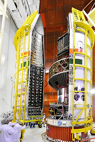
Cartosat-1 is a stereoscopic Earth observation satellite in a Sun-synchronous orbit, and the first one of the Cartosat series of satellites. The eleventh satellite of ISRO in Indian Remote Sensing Satellite (IRS) series. The satellite was launched by Indian Space Research Organisation and is operated by NTRO. Weighing around 1560 kg at launch, its applications will mainly be towards cartography in India.

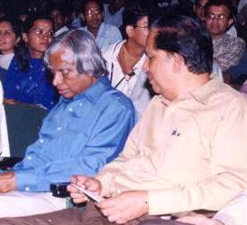
G. Madhavan Nair is an Indian space scientist and a former Chairman of the Indian Space Research Organisation, and Secretary to the Department of Space, Government of India. He has also been the Chairman of the Space Commission and Chairman of the Governing Body of the Antrix Corporation, Bangalore.

Cartosat-2 is an Earth observation satellite in a Sun-synchronous orbit and the second of the Cartosat series of satellites. The satellite was built, launched and maintained by the Indian Space Research Organisation (ISRO). Weighing around 680 kg at launch, its applications will mainly be towards cartography in India. It was launched by the Polar Satellite Launch Vehicle PSLV-C7 launch vehicle on 10 January 2007.

Cartosat-3 is an advanced Indian Earth Observation satellite built and developed by Indian Space Research Organisation (ISRO), which replaces the Indian Remote Sensing Satellite (IRS) series. It has a panchromatic resolution of 0.25 metres making it one of the imaging satellite with highest resolution in the world at the time of launch and MX of 1 metre with a high quality resolution which is a major improvement from the previous payloads in the Cartosat series.
Cartosat-2A is an Earth observation satellite in a Sun-synchronous orbit and the third of the Cartosat series of satellites. The satellite is the thirteenth satellite in the Indian Remote Sensing (IRS) satellite series to be built, launched by the Indian Space Research Organisation.
The Integrated Space Cell was the nodal agency within the Government of India which oversees the security of its space based military and civilian hardware systems. It was to be jointly operated by all the three services of the Indian Armed Forces, the civilian Defence Research and Development Organisation and the Indian Space Research Organisation (ISRO). This agency was superseded by Defence Space Agency in 2019.[better source needed]

RISAT (Radar Imaging Satellite) is a series of Indian radar imaging reconnaissance satellites built by the Indian Space Research Organization (ISRO). They provide all-weather surveillance using synthetic aperture radars (SAR).
Bhuvan is an Indian web-based utility which allows users to explore a set of geographic content prepared by the Indian Space Research Organisation. The content which the utility serves is mostly restricted to within Indian boundaries and is offered in four regional languages. The content includes thematic maps related to disasters, agriculture, water resources, land cover, and processed satellite data generated by ISRO.
Cartosat-2B is an Earth observation satellite in a Sun-synchronous orbit and the fourth of the Cartosat series of satellites. The satellite is the seventeenth satellite in the Indian Remote Sensing (IRS) satellite series to be built by the Indian Space Research Organisation (ISRO).
IRS-1D is the seventh satellite in Indian Remote Sensing satellite series of Earth Observation satellites, built, launched and maintained by Indian Space Research Organisation (ISRO). The satellite has similar capabilities as that of ISRO's IRS-1C satellite with some improvements added for better imagery particularly in thematic mapping.
IRS-P2 was an Earth observation satellite launched under the National Natural Resources Management System (NNRMS) programme undertaken by Indian Space Research Organisation (ISRO). The objectives of the mission were to provide spaceborne capability to India in observing and managing natural resources and utilizing them in a productive manner. The satellite carried imaging multi-spectral radiometers on board for radio sensing of the resources.
The Cartosat is a series of Indian optical earth observation satellites built and operated by the Indian Space Research Organisation (ISRO). The Cartosat series is a part of the Indian Remote Sensing Program. They are used for Earth's resource management, defence services and monitoring.

The NASA-ISRO Synthetic Aperture Radar (NISAR) mission is a joint project between NASA and ISRO to co-develop and launch a dual-frequency synthetic aperture radar on an Earth observation satellite. The satellite will be the first radar imaging satellite to use dual frequencies. It will be used for remote sensing, to observe and understand natural processes on Earth. For example, its left-facing instruments will study the Antarctic cryosphere. With a total cost estimated at US$1.5 billion, NISAR is likely to be the world's most expensive Earth-imaging satellite.

Aluru Seelin Kiran Kumar is an Indian space scientist and former chairman of the Indian Space Research Organisation, having assumed office on 14 January 2015. He is credited with the development of key scientific instruments aboard the Chandrayaan-1 and Mangalyaan space crafts. In 2014, he was awarded the Padma Shri, India's fourth highest civilian award, for his contributions to the fields of science and technology. Kiran Kumar previously served as Director of Ahmedabad Space Applications Centre.
Cartosat-2C is an Earth observation satellite in a Sun-synchronous orbit (SSO) and is a fifth flight unit of Cartosat series of satellites. It is a geostationary satellite and appears stationary over a place on the earth. The satellite is built at space application centre Ahmedabad, launched and maintained by the Indian Space Research Organisation (ISRO). It was launched on 22 June 2016.
Cartosat-2E is an Earth observation satellite developed by the Indian Space Research Organisation (ISRO), and is the seventh in the Cartosat series. It is designed to collect high-resolution, large-scale imagery for use in urban planning, infrastructure development, utilities planning, and traffic management.

PSLV-C37 was the 39th mission of the Indian Polar Satellite Launch Vehicle (PSLV) program and its 16th mission in the XL configuration undertaken by the Indian Space Research Organisation (ISRO). Launched on 15 February 2017 from the Satish Dhawan Space Centre at Sriharikota, Andhra Pradesh, the rocket successfully carried and deployed a record number of 104 satellites in sun-synchronous orbits in a single mission, breaking the earlier record of launching 37 satellites by a Russian Dnepr rocket on 19 June 2014. This record was held until the launch of the Transporter-1 mission by SpaceX on 24 January 2021 which launched 143 satellites.

Cartosat-2D is an Earth observation satellite in a Sun-synchronous orbit (SSO) and the fifth of the Cartosat series of satellites. The satellite is built, launched and maintained by the Indian Space Research Organisation (ISRO). Cartosat-2D has a mass of 714 kg.

Cartosat-2F is the eighth satellite in the Cartosat-2 Series. It is an Earth observation satellite launched on the PSLV-C40 mission by the Indian Space Research Organisation (ISRO).


