Hudson Falls | |
---|---|
Coordinates: 43°18′8″N73°34′50″W / 43.30222°N 73.58056°W | |
Country | United States |
State | New York |
County | Washington |
Incorporated | 1810 as Sandy Hill, 1910 as Hudson Falls |
Government | |
• Mayor | John Barton |
Area | |
• Total | 1.92 sq mi (4.97 km2) |
• Land | 1.86 sq mi (4.82 km2) |
• Water | 0.06 sq mi (0.15 km2) |
Elevation | 295 ft (90 m) |
Population (2020) | |
• Total | 7,428 |
• Density | 3,990.87/sq mi (1,540.49/km2) |
Time zone | UTC-5 (Eastern (EST)) |
• Summer (DST) | UTC-4 (EDT) |
ZIP code | 12839 |
Area code | 518 |
FIPS code | 36-35980 |
GNIS feature ID | 0974163 |
Website | Village website |
Hudson Falls (formerly Sandy Hill) is a village located in Washington County, New York, United States. The village is in the southwest of the town of Kingsbury, on U.S. Route 4. Hudson Falls is part of the Glens Falls Metropolitan Statistical Area. [2] As of the 2020 census, the village had a population of 7,428. [3] It was the county seat of Washington County until 1994, when the county seat was moved to Fort Edward. [4] [5]
This section needs additional citations for verification .(June 2023) |
In 1764, Albert Baker built Kingsbury's first sawmill near what is known today as Baker's Falls. [6] As early as 1792, the area of Kingsbury near Baker's Falls was referred to as Sandy Hill. In 1810, the hamlet incorporated as a village, keeping the name Sandy Hill. Its boundaries expanded to their current limits in the 1840s.
Around 1824, the Glens Falls Feeder Canal was constructed to bring water from the Hudson River to the Champlain Canal. With the opening of the Feeder Canal, Sandy Hill became a prosperous manufacturing center, producing lumber, paper, pianos, wagons, pulleys, and other products. The Glens Falls Feeder Canal is no longer used commercial traffic, but the route of Canal is a fourteen mile long park, with a walking and bike trail on the old tow path. [7]
Stone quarried in Hudson Falls was used to construct the Bennington Battle Monument (1889) and the Brooklyn Bridge. The former site of the quarry has been redeveloped for use by the Washington-Saratoga-Warren-Hamilton-Essex Board of Cooperative Educational Services.
In 1851, Francis Wolle invented the first bag-making machine and formed a company that would later become the Union Bag and Paper Company. In 1892, the company relocated from Bethlehem, Pennsylvania, to Hudson Falls, where it had a paper mill. In 1906, the Union Paper and Bag Company built the Fenimore Bridge (Sandy Hill Bridge), spanning the Hudson River between Hudson Falls built in Washington County and the town of Moreau in Saratoga County, since the company had plants in both locations. For a brief period of time, the closed-spandrel arch bridge was the longest multiple span, reinforced-concrete arch bridge in the world. [8] [9] The bridge was closed to all traffic in 1989, although various plans have been proposed over the years to reopen the span; for example, in 2018, there was a proposal to convert it into a pedestrian walkway and bike path. [10]
In 1910, the village's name was changed from Sandy Hill to Hudson Falls. [7] The Glens Falls Feeder Canal, Hudson Falls Historic District, and United States Post Office are listed on the National Register of Historic Places. [15]
According to the United States Census Bureau, the village has a total area of 1.9 square miles (4.9 km2), of which 1.8 square miles (4.7 km2) are land and 0.04 square miles (0.10 km2) are water. The total area is 2.13% water.
The village is on the east bank of the Hudson River at the western border of Washington County. A village green lies in the center of the commercial district.
NY Route 196 (Maple Street) and NY Route 254 (River Street) intersect US Route 4 in Hudson Falls.
Census | Pop. | Note | %± |
---|---|---|---|
1870 | 2,347 | — | |
1880 | 2,487 | 6.0% | |
1890 | 2,895 | 16.4% | |
1900 | 4,473 | 54.5% | |
1910 | 5,189 | 16.0% | |
1920 | 5,761 | 11.0% | |
1930 | 6,449 | 11.9% | |
1940 | 6,654 | 3.2% | |
1950 | 7,236 | 8.7% | |
1960 | 7,752 | 7.1% | |
1970 | 7,917 | 2.1% | |
1980 | 7,419 | −6.3% | |
1990 | 7,651 | 3.1% | |
2000 | 6,927 | −9.5% | |
2010 | 7,281 | 5.1% | |
2020 | 7,427 | 2.0% | |
U.S. Decennial Census [20] |
As of the census of 2000, there were 6,927 people, 2,876 households, and 1,760 families residing in the village. The population density was 3,763.5 inhabitants per square mile (1,453.1/km2). There were 3,120 housing units at an average density of 1,695.1 units per square mile (654.5 units/km2). The racial makeup of the village was 97.91% White, 0.45% African American, 0.22% Native American, 0.25% Asian, 0.00% Pacific Islander, 0.16% from other races, and 1.02% from two or more races. 0.68% of the population is Hispanic or Latino of any race. [21]
There were 2,876 households, out of which 31.4% had children under the age of 18 living with them, 40.7% were married couples living together, 15.5% had a female householder with no husband present, and 38.8% were non-families. 32.0% of all households were made up of individuals, and 13.7% had someone living alone who was 65 years of age or older. The average household size was 2.37 and the average family size was 2.95. [21]
In the village, the population was spread out, with 25.2% under the age of 18, 8.9% from 18 to 24, 30.6% from 25 to 44, 20.6% from 45 to 64, and 14.6% who were 65 years of age or older. The median age was 36 years. For every 100 females, there were 88.5 males. For every 100 females age 18 and over, there were 83.8 males. [21]
The median income for a household in the village was $31,516, and the median income for a family was $37,628. Males had a median income of $31,107 versus $21,215 for females. The per capita income for the village was $17,575. 17.2% of the population and 12.8% of families were below the poverty line. 30.3% of those under the age of 18 and 6.3% of those 65 and older were living below the poverty line. [21]
Amtrak, the national passenger rail system, provides service to Hudson Falls at the station in nearby Fort Edward, operating its Adirondack daily in both directions between Montreal and New York City, and its Ethan Allen Express in both directions daily between New York City and Rutland. Amtrak has designated the stop as Fort Edward-Glens Falls.
Freight rail service is provided along a spur line extending from Fort Edward to Glens Falls that runs through the village.
The fictional town of Millers Kill, NY, in Julia Spencer-Fleming's mystery novels is loosely based on Hudson Falls. [22]
Wappingers Falls is a village in the towns of Poughkeepsie and Wappinger, in Dutchess County, New York, United States. As of the 2010 census it had a population of 5,522. The community was named for the cascade in Wappinger Creek. The Wappingers Falls post office covers areas in the towns of Wappinger, Poughkeepsie, Fishkill, East Fishkill, and LaGrange. This can result in some confusion when residents of the outlying towns, who do not live in the village, give their address as "Wappingers Falls".
Phoenix is a village in Oswego County, New York, United States. The population was 2,382 at the 2010 census. The name is derived from Alexander Phoenix. The village of Phoenix lies in the Lake Ontario lake-effect snow belt, with seasonal snow totals regularly exceeding 200 in (510 cm). Phoenix lies in the southwest part of the town of Schroeppel.
Moreau is a town in Saratoga County, New York, United States. The population was 16,202 at the 2020 census. The town is located in the northeast part of the county, north of Saratoga Springs. Moreau is named after Jean Victor Moreau, a French general, who visited the area just before the town was formed. The town contains a village called South Glens Falls.
Schuylerville is a village in Saratoga County, New York, United States. The village is located in the northeastern part of the Town of Saratoga, east of Saratoga Springs. The Village of Victory is adjacent to Schuylerville to the southwest and the Hudson River forms the village's eastern border. The population was 1,370 at the 2020 census. The village was incorporated in 1831 and is named after the Schuyler family, a prominent family of Dutch descent in colonial America.
South Glens Falls is a village in Saratoga County, New York, United States. The population was 3,744 at the 2020 census. The village is in the northern part of the Town of Moreau, south of the City of Glens Falls.
Dix is a town in Schuyler County, New York, United States. The population was 3,723 at the 2020 census.
Montour Falls is a village located in Schuyler County, New York, United States. The population was 2,714 at the time of the 2020 census. A waterfall at the end of West Main Street gives the village its name. The name "Montour" is derived from Queen Catharine Montour, a prominent Native American woman of Seneca Indian heritage who lived at the village site in the 18th century.
Rosendale is a town in the center of Ulster County, New York, United States. It once contained a village Rosendale, primarily centered around Main Street, but which was dissolved through vote in 1977. The population was 5,782 at the 2020 census.
Glens Falls is a city in Warren County, New York, United States and is the central city of the Glens Falls Metropolitan Statistical Area. The population was 14,830 at the 2020 census. The name was given by Colonel Johannes Glen, the falls referring to a large waterfall in the Hudson River at the southern end of the city.
Thurman is a town in the western part of Warren County, New York, United States. It is part of the Glens Falls Metropolitan Statistical Area. The town population was 1,199 at the 2000 census. The town is named after John Thurman, an early landowner. The town lies entirely inside the Adirondack Park.
Kingsbury is a town in western Washington County, New York, United States. It is part of the Glens Falls Metropolitan Statistical Area. The town population was 12,968 at the 2020 census, up from 12,671 at the 2010 census.
Amsterdam is a city in Montgomery County, New York, United States. As of the 2020 census, the city had a population of 18,219. The city is named after Amsterdam in the Netherlands.
Waterford is a village in Saratoga County, New York, United States. The population was 2,038 at the 2020 census. The name derives from the ford between the mainland and Peebles Island.
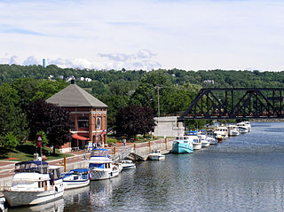
Waterford is a town in Saratoga County, New York, United States. The population was 8,208 at the 2020 census. The name of the town is derived from its principal village, also called Waterford. The town is located in the southeast corner of Saratoga County and north-northwest of Troy at the junction of the Erie Canal and the Hudson River.
Nathaniel Pitcher was an American lawyer and politician who served as the eighth governor of New York from February 11 to December 31, 1828.
New York State Route 196 (NY 196) is an east–west state highway located within Washington County, New York, in the United States. It extends for 10.27 miles (16.53 km) from an intersection with U.S. Route 4 (US 4) in the village of Hudson Falls to a junction with NY 40 in the Hartford hamlet of South Hartford. Just east of Hudson Falls, NY 196 intersects the northern terminus of NY 32, which actually intersects NY 196 on its north side.
U.S. Route 4 (US 4) is a part of the United States Numbered Highway System that runs from East Greenbush, New York, to Portsmouth, New Hampshire. In the U.S. state of New York, US 4 extends 79.67 miles (128.22 km) from an intersection with US 9 and US 20 in East Greenbush to the Vermont state line northeast of Whitehall. While the remainder of US 4 east of New York is an east–west route, US 4 in New York is signed north–south due to the alignment the route takes through the state. The portion of the route between Waterford and Whitehall is part of the Lakes to Locks Passage, an All-American Road.
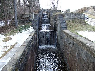
The Glens Falls Feeder Canal is a canal from Glens Falls, New York, United States through Hudson Falls and into Fort Edward. It is seven miles (11 km) long and delivers water from above Glens Falls on the Hudson River to the highest point of the Champlain Canal. The Feeder Canal Heritage Trail runs along a large part of the canal.
Fort Ann is a village in Washington County, New York, United States. It is part of the Glens Falls Metropolitan Statistical Area. The village population was 484 at the 2010 census. The name is derived indirectly from Queen Anne and the local fortification built in 1757 and named after her.
Fort Edward is a town and the county seat of Washington County, New York, United States. The population was 5,991 at the 2020 census. The municipal center complex is on U.S. Route 4 between the villages of Hudson Falls and Fort Edward. When construction of the complex was completed in 1994, most of the administrative offices were moved from the original county seat of Hudson Falls to this location. The town of Fort Edward is part of the Glens Falls Metropolitan Statistical Area.
The bridge was closed in 1989. But it has been used by pedestrians and snowmobilers on occasion since then, despite all access being forbidden.