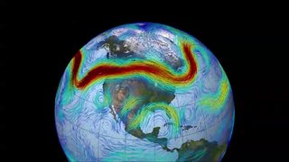
Jet streams are fast flowing, narrow air currents in the Earth's atmosphere.

The tropics are the regions of Earth surrounding the Equator, where the sun may shine directly overhead. This contrasts with the temperate or polar regions of Earth, where the Sun can never be directly overhead. This is because of Earth's axial tilt; the width of the tropics is twice the tilt. The tropics are also referred to as the tropical zone and the torrid zone.

An anticyclone is a weather phenomenon defined as a large-scale circulation of winds around a central region of high atmospheric pressure, clockwise in the Northern Hemisphere and counterclockwise in the Southern Hemisphere as viewed from above. Effects of surface-based anticyclones include clearing skies as well as cooler, drier air. Fog can also form overnight within a region of higher pressure.

The subtropical zones or subtropics are geographical and climate zones immediately to the north and south of the tropics. Geographically part of the temperate zones of both hemispheres, they cover the middle latitudes from 23°26′09.7″ (or 23.43604°) to approximately 35° north and south. The horse latitudes lie within this range.

The Intertropical Convergence Zone, known by sailors as the doldrums or the calms because of its monotonous windless weather, is the area where the northeast and the southeast trade winds converge. It encircles Earth near the thermal equator though its specific position varies seasonally. When it lies near the geographic equator, it is called the near-equatorial trough. Where the ITCZ is drawn into and merges with a monsoonal circulation, it is sometimes referred to as a monsoon trough.

Atmospheric circulation is the large-scale movement of air and together with ocean circulation is the means by which thermal energy is redistributed on the surface of the Earth. The Earth's atmospheric circulation varies from year to year, but the large-scale structure of its circulation remains fairly constant. The smaller-scale weather systems – mid-latitude depressions, or tropical convective cells – occur chaotically, and long-range weather predictions of those cannot be made beyond ten days in practice, or a month in theory.

A high-pressure area, high, or anticyclone, is an area near the surface of a planet where the atmospheric pressure is greater than the pressure in the surrounding regions. Highs are middle-scale meteorological features that result from interplays between the relatively larger-scale dynamics of an entire planet's atmospheric circulation.

In meteorology, a low-pressure area, low area or low is a region where the atmospheric pressure is lower than that of surrounding locations. It is the opposite of a high-pressure area. Low-pressure areas are commonly associated with inclement weather, while high-pressure areas are associated with lighter winds and clear skies. Winds circle anti-clockwise around lows in the northern hemisphere, and clockwise in the southern hemisphere, due to opposing Coriolis forces. Low-pressure systems form under areas of wind divergence that occur in the upper levels of the atmosphere (aloft). The formation process of a low-pressure area is known as cyclogenesis. In meteorology, atmospheric divergence aloft occurs in two kinds of places:

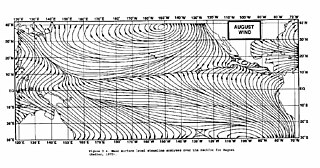
The trade winds or easterlies are permanent east-to-west prevailing winds that flow in the Earth's equatorial region. The trade winds blow mainly from the northeast in the Northern Hemisphere and from the southeast in the Southern Hemisphere, strengthening during the winter and when the Arctic oscillation is in its warm phase. Trade winds have been used by captains of sailing ships to cross the world's oceans for centuries. They enabled European colonization of the Americas, and trade routes to become established across the Atlantic Ocean and the Pacific Ocean.

In meteorology, prevailing wind in a region of the Earth's surface is a surface wind that blows predominantly from a particular direction. The dominant winds are the trends in direction of wind with the highest speed over a particular point on the Earth's surface at any given time. A region's prevailing and dominant winds are the result of global patterns of movement in the Earth's atmosphere. In general, winds are predominantly easterly at low latitudes globally. In the mid-latitudes, westerly winds are dominant, and their strength is largely determined by the polar cyclone. In areas where winds tend to be light, the sea breeze-land breeze cycle is the most important cause of the prevailing wind. In areas which have variable terrain, mountain and valley breezes dominate the wind pattern. Highly elevated surfaces can induce a thermal low, which then augments the environmental wind flow. Wind direction at any given time is influenced by synoptic-scale and mesoscale weather like pressure systems and fronts. Local wind direction can also be influenced by microscale features like buildings.

The westerlies, anti-trades, or prevailing westerlies, are prevailing winds from the west toward the east in the middle latitudes between 30 and 60 degrees latitude. They originate from the high-pressure areas in the horse latitudes and trend towards the poles and steer extratropical cyclones in this general manner. Tropical cyclones which cross the subtropical ridge axis into the westerlies recurve due to the increased westerly flow. The winds are predominantly from the southwest in the Northern Hemisphere and from the northwest in the Southern Hemisphere.

The Humboldt Current, also called the Peru Current, is a cold, low-salinity ocean current that flows north along the western coast of South America. It is an eastern boundary current flowing in the direction of the equator, and extends 500–1,000 km (310–620 mi) offshore. The Humboldt Current is named after the German naturalist Alexander von Humboldt even though it was discovered by José de Acosta 250 years before Humboldt. In 1846, von Humboldt reported measurements of the cold-water current in his book Cosmos.
The South Pacific Convergence Zone (SPCZ), a reverse-oriented monsoon trough, is a band of low-level convergence, cloudiness and precipitation extending from the Western Pacific Warm Pool at the maritime continent south-eastwards towards French Polynesia and as far as the Cook Islands. The SPCZ is a portion of the Intertropical Convergence Zone (ITCZ) which lies in a band extending east–west near the Equator but can be more extratropical in nature, especially east of the International Date Line. It is considered the largest and most important piece of the ITCZ, and has the least dependence upon heating from a nearby landmass during the summer than any other portion of the monsoon trough. The SPCZ can affect the precipitation on Polynesian islands in the southwest Pacific Ocean, so it is important to understand how the SPCZ behaves with large-scale, global climate phenomenon, such as the ITCZ, El Niño–Southern Oscillation, and the Interdecadal Pacific oscillation (IPO), a portion of the Pacific decadal oscillation.

The Madden–Julian oscillation (MJO) is the largest element of the intraseasonal variability in the tropical atmosphere. It was discovered in 1971 by Roland Madden and Paul Julian of the American National Center for Atmospheric Research (NCAR). It is a large-scale coupling between atmospheric circulation and tropical deep atmospheric convection. Unlike a standing pattern like the El Niño–Southern Oscillation (ENSO), the Madden–Julian oscillation is a traveling pattern that propagates eastward, at approximately 4 to 8 m/s, through the atmosphere above the warm parts of the Indian and Pacific oceans. This overall circulation pattern manifests itself most clearly as anomalous rainfall.

The North Equatorial Current (NEC) is a westward wind-driven current mostly located near the equator, but the location varies from different oceans. The NEC in the Pacific and the Atlantic is about 5°-20°N, while the NEC in the Indian Ocean is very close to the equator. It ranges from the sea surface down to 400 m in the western Pacific.

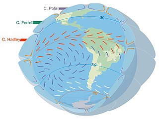
The Hadley cell, also known as the Hadley circulation, is a global-scale tropical atmospheric circulation that features air rising near the equator, flowing poleward near the tropopause at a height of 12–15 km (7.5–9.3 mi) above the Earth's surface, cooling and descending in the subtropics at around 25 degrees latitude, and then returning equatorward near the surface. It is a thermally direct circulation within the troposphere that emerges due to differences in insolation and heating between the tropics and the subtropics. On a yearly average, the circulation is characterized by a circulation cell on each side of the equator. The Southern Hemisphere Hadley cell is slightly stronger on average than its northern counterpart, extending slightly beyond the equator into the Northern Hemisphere. During the summer and winter months, the Hadley circulation is dominated by a single, cross-equatorial cell with air rising in the summer hemisphere and sinking in the winter hemisphere. Analogous circulations may occur in extraterrestrial atmospheres, such as on Venus and Mars.

The monsoon trough is a portion of the Intertropical Convergence Zone in the Western Pacific, as depicted by a line on a weather map showing the locations of minimum sea level pressure, and as such, is a convergence zone between the wind patterns of the southern and northern hemispheres.

Tropical cyclogenesis is the development and strengthening of a tropical cyclone in the atmosphere. The mechanisms through which tropical cyclogenesis occur are distinctly different from those through which temperate cyclogenesis occurs. Tropical cyclogenesis involves the development of a warm-core cyclone, due to significant convection in a favorable atmospheric environment.

The characteristics of United States rainfall climatology differ significantly across the United States and those under United States sovereignty. Summer and early fall bring brief, but frequent thundershowers and tropical cyclones which create a wet summer and drier winter in the eastern Gulf and lower East Coast. During the winter, and spring, Pacific storm systems bring Hawaii and the western United States most of their precipitation. Low pressure systems moving up the East Coast and through the Great Lakes, bring cold season precipitation to from the Midwest to New England, as well as Great Salt Lake. The snow to liquid ratio across the contiguous United States averages 13:1, meaning 13 inches (330 mm) of snow melts down to 1 inch (25 mm) of water.

Earth rainfall climatology Is the study of rainfall, a sub-field of meteorology. Formally, a wider study includes water falling as ice crystals, i.e. hail, sleet, snow. The aim of rainfall climatology is to measure, understand and predict rain distribution across different regions of planet Earth, a factor of air pressure, humidity, topography, cloud type and raindrop size, via direct measurement and remote sensing data acquisition. Current technologies accurately predict rainfall 3–4 days in advance using numerical weather prediction. Geostationary orbiting satellites gather IR and visual wavelength data to measure realtime localised rainfall by estimating cloud albedo, water content, and the corresponding probability of rain.


