The Toronto Transit Commission (TTC) is the primary public transport agency in Toronto, Ontario, Canada, operating the majority of the city's bus and rail services. It is the oldest and largest of the urban transit service providers in the Greater Toronto Area, with numerous connections to systems serving its surrounding municipalities.

Line 3 Scarborough, originally known as Scarborough RT (SRT), is a defunct medium-capacity rapid transit line that was part of the Toronto subway system in Toronto, Ontario, Canada. The line ran entirely within the eastern district of Scarborough, encompassing six stations and 6.4 kilometres (4.0 mi) of mostly elevated track. It connected with Line 2 Bloor–Danforth at its southwestern terminus, Kennedy, and terminated in the northeast at McCowan. Until its closure in July 2023, the system had a ridership of 3,908,000 per year.

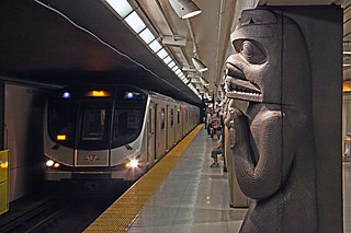
Line 4 Sheppard is the newest and shortest rapid transit line of the Toronto subway system, operated by the Toronto Transit Commission (TTC). It opened on November 22, 2002, and has five stations along 5.5 kilometres (3.4 mi) of track, which is built without any open sections in the district of North York along Sheppard Avenue East between Yonge Street and Don Mills Road. All stations are wheelchair accessible and are decorated with unique public art.

The Toronto subway is a rapid transit system serving Toronto and the neighbouring city of Vaughan in Ontario, Canada, operated by the Toronto Transit Commission (TTC). The subway system is a rail network consisting of three heavy-capacity rail lines operating predominantly underground. As of October 2024, three new lines are under construction: two light rail lines and one subway line.

Line 2 Bloor–Danforth is a rapid transit line in the Toronto subway system, operated by the Toronto Transit Commission (TTC). It has 31 stations and is 26.2 kilometres (16.3 mi) in length. It opened on February 26, 1966, and extensions at both ends were completed in 1968 and again in 1980.

Kennedy is the eastern terminal station on Line 2 Bloor–Danforth of the Toronto subway system. Opened in 1980, it is located east of the Kennedy Road and Eglinton Avenue intersection. With the adjacent Kennedy GO station on the Stouffville line of GO Transit, Kennedy is an intermodal transit hub and the fifth busiest station in the system, after Bloor–Yonge, St. George, Sheppard–Yonge, and Union, serving a total of approximately 50,503 customer trips a day.

Scarborough Centre is a bus terminal in Toronto, Ontario, Canada, serving multiple bus routes of the Toronto Transit Commission (TTC) and one Durham Regional Transit (DRT) bus route. It was also a rapid transit station serving Line 3 Scarborough of the Toronto subway system until Line 3's closure on July 24, 2023. It is located north of Ellesmere Road between Brimley and McCowan Roads, just south of Highway 401. It was adjacent to the former Scarborough Centre Bus Terminal, which was a station for GO Transit buses and other intercity coach services until the TTC modified the facility for TTC buses.

Kitchener is one of the seven train lines of the GO Transit system in the Greater Toronto Area, Ontario, Canada. It extends westward from Union Station in Toronto to Kitchener, though most trains originate and terminate in Brampton in off-peak hours.

Stouffville is one of the seven train lines of the GO Transit system in the Greater Toronto Area, Ontario, Canada. Its southern terminus is Union Station in Toronto, and its northern terminus is Old Elm in Whitchurch-Stouffville. There are connections from almost every station to Toronto Transit Commission or York Region Transit bus services.

Agincourt GO Station is a GO Transit railway station in Toronto, Ontario, Canada. The Stouffville line station serves the Agincourt neighbourhood of the former suburb of Scarborough.

Durham College Oshawa GO station is a station for commuter rail, passenger rail and regional bus services in Oshawa, Ontario, Canada. It is the terminal station for the Lakeshore East line of GO Transit and serves Via Rail's Corridor service, which travels from Toronto to both Ottawa and Montreal. The bus terminal is served by bus routes of GO Transit and Durham Region Transit.

The Union Station Bus Terminal is the central intercity bus terminal in Toronto, Ontario, Canada. It is located in Downtown Toronto on the second floor of the south tower of CIBC Square, on the northeast corner of Bay Street and Lake Shore Boulevard. The terminal currently serves GO Transit regional buses as well as Coach Canada, Greyhound Lines and Ontario Northland long-distance bus services, among others. Owned by the provincial Crown agency Metrolinx, the terminal is connected by pedestrian walkways to the adjacent Union Station, Canada's busiest transportation hub.

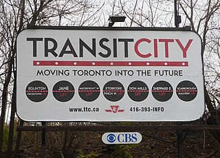
Transit City was a plan for developing public transport in Toronto, Ontario, Canada. It was first proposed and announced on 16 March 2007 by Toronto mayor David Miller and Toronto Transit Commission (TTC) chair Adam Giambrone. The plan called for the construction of seven new light rail lines along the streets of seven priority transit corridors, which would have eventually been integrated with existing rapid transit, streetcar, and bus routes. Other transit improvements outlined in the plan included upgrading and extending the Scarborough RT line, implementing new bus rapid transit lines, and improving frequency and timing of 21 key bus routes. The plan integrated public transportation objectives outlined in the City of Toronto Official Plan, the TTC Ridership Growth Strategy and Miller's 2006 election platform.

Line 5 Eglinton, also known as the Eglinton Crosstown LRT or the Crosstown, is a light rail transit line that is under construction in Toronto, Ontario, Canada, to expand and improve public transportation in the Greater Toronto Area. Owned by Metrolinx and operated by the Toronto Transit Commission (TTC), the line will be part of the Toronto subway system. The Crosstown was conceived in 2007 during the administration of Toronto mayor David Miller as part of Transit City, a large-scale transit expansion plan. The line is being constructed in two phases.
The Eglinton East LRT (EELRT), also known as Line 7 Eglinton East and formerly known as the Scarborough Malvern LRT, is a proposed light rail line in Toronto, Ontario, Canada. The line would be entirely within the district of Scarborough. It was originally part of Transit City, a 2007 plan to develop new light rail lines along several priority transit corridors in the city.

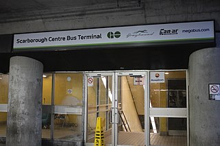
Scarborough Centre Bus Terminal is a regional and intercity bus terminal in Scarborough City Centre in Toronto, Ontario, Canada, located near its namesake rapid transit station on Line 3 Scarborough of the Toronto subway. It is served by GO Transit buses. The terminal is near the Scarborough Town Centre shopping mall and the Scarborough Civic Centre. Until 2022, Megabus, and other private coach services used the terminal, but have moved to temporary on-street locations nearby due to subway construction.

Canadian National Railway's Kingston Subdivision, or Kingston Sub for short, is a major railway line connecting Toronto with Montreal that carries the majority of CN traffic between these points. The line was originally the main trunk for the Grand Trunk Railway between these cities, although there has been some realignment of the route between these cities. The majority of the Kingston Sub runs close to the northern bank of Lake Ontario and the Saint Lawrence River.

Mount Dennis is an intermodal transit terminal under construction in Toronto, Ontario, Canada. Located east of the intersection of Eglinton Avenue and Weston Road in the Mount Dennis neighbourhood in the district of York, the station will be the western terminus of the future Line 5 Eglinton as well as an intermediate station on the GO Transit Kitchener line and Union Pearson Express. The station has been designated as one of many "mobility hubs" in Greater Toronto. It is scheduled to open in 2024.

Renforth, referred to during planning as Renforth Gateway, is a bus station on the border of the cities of Mississauga and Toronto, in Ontario, Canada. Located at Eglinton Avenue and Renforth Drive, it is the eastern terminus of the Mississauga Transitway and is close to the interchange between Highway 401 and Highway 427.
The Big Move is a regional transportation plan (RTP) published in 2008 and consisting of 62 rapid transit projects to be implemented across the Greater Toronto and Hamilton Area (GTHA). These rapid transit projects are intended to form a seamlessly integrated regional rapid transit network, which is the first priority action in the regional transportation plan. These projects form two long-term templates with 15 and 25 year horizons. These templates outline broad projects; specific details about technology, alignment, stations and service levels for each project are subsequently determined though a cost–benefit analysis or an environmental assessment process.


