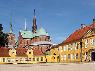
Roskilde is a city 30 km (19 mi) west of Copenhagen on the Danish island of Zealand. With a population of 52,974, the city is a business and educational centre for the region and the 10th largest city in Denmark. It is governed by the administrative council of Roskilde Municipality.
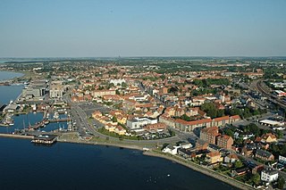
Nyborg is a city in central Denmark, located in Nyborg Municipality on the island of Funen and with a population of 17,902 (2024). It is the easternmost settlement on Funen. By road, it is located 34 km east of Odense, 35 km north of Svendborg and 21 km south of Kerteminde. It also connects to Korsør through the Great Belt Bridge. Nyborg is the seat of Nyborg Municipality, and until 1793 it was also the seat of Nyborg County.

Glostrup Municipality is a suburban municipality and town in Region Hovedstaden on the island of Zealand (Sjælland) approx. 10 km west of Copenhagen in eastern Denmark. The municipality covers an area of 13.31 km2, and has a total population of 23,655 (2024). Its Zip code (Postnummer) is 2600. Its mayor as of 2022 is Kasper Damsgaard, a member of the Social Democrats (Socialdemokratiet) political party. The municipality was established in 1841 following the municipal reforms of the 1840s, ranking as a parish municipality (sognekommune) until 1950 when suburbanisation of Copenhagen inhabited the municipality and the status was changed to town municipality (købstadskommune). From 1947 to 1960 the population in the municipality doubled due to the expanding suburbs of Copenhagen, reaching the municipality in the post-war period. Glostrup was designated as a new suburb along the western Tåstrup-finger of the Copenhagen Finger Plan of 1947.
Herlev Municipality is a municipality in the northwestern suburbs of Copenhagen, Capitl Region, Denmark. The municipality covers an area of 12 km², and has a total population of 29,876. Its mayor is Thomas Gyldal Petersen, a member of the Social Democrats (Socialdemokraterne) political party. The former village Herlev is the largest settlement of the municipal and the site of the municipal council. It is best known for being the site of Herlev Hospital.
Holbæk is a town in Denmark and the seat of Holbæk municipality with a population of 30,503. It is located in the northwestern part of Region Sjælland, Denmark.
Virum is a mostly residential, suburban neighbourhood in Lyngby-Taarbæk Municipality, located on both sides of Lyngby Kongevej, approximately 15 km north of central Copenhagen, Denmark. The neighbourhood is bordered by Lake Furesø to the west, Holte in Rudersdal Municipality to the north, Brede to the east and Kongens Lyngby and Sorgenfri to the south.

The Capital Region of Denmark is the easternmost administrative region of Denmark, and contains Copenhagen, the national capital.

Valby ( ) is one of the 10 official districts of Copenhagen Municipality, Denmark. It is in the southwestern corner of Copenhagen Municipality, and has a mixture of different types of housing. This includes apartment blocks, terraced housing, areas with single-family houses and allotments, plus the remaining part of the old Valby village, around which the district has formed, intermingled with past and present industrial sites.

One of the six S-train radial lines in Copenhagen runs along the long-distance tracks on Vestbanen and provides local train service on its inner parts. The S-trains end at Høje Taastrup about 20 km west of the city centre.
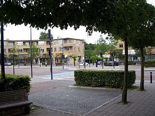
Glostrup station is a commuter rail railway station serving the railway town/suburb of Glostrup west of Copenhagen, Denmark. It is located close to the historical, administrative and commercial centre of Glostrup Municipality, but also serves Brøndbyvester in Brøndby Municipality, the boundary of which comes within a few hundred metres from the station. The station is connected to the nearby Glostrup Shopping Center via an underground walkway, the same walkway which is used to access the platforms.
Hedehusene is a suburban town located on the rail line between Copenhagen and Roskilde in the Capital Region of Denmark. It has absorbed the villages of Baldersbrønde and Fløng and almost merged with Roskilde's eastern Trekroner neighbourhood to the west and Høje Taastrup to the east. To the south is the large recreational area Hedeland. As of 1 January 2024, the town had a population of 16,049. A large development project, NærHeden, created as a collaboration between Høje-Taastrup Municipality and Realdania, will expand the town to the southeast with a new sustainable neighbourhood.

Taastrup is a Danish railway town and suburb of Copenhagen – 18 km west of Copenhagen's city centre. The town forms a twin urban area with neighbouring suburb Høje Taastrup, Taastrup rising since 1859 and Høje Taastrup rising west of the town, since the 1970s. The town/suburb development has engulfed the villages of Taastrup Valby, Høje Taastrup, Kragehave and Klovtofte, although Høje Taastrup still has a preserved village character around Høje Taastrup Church. The town is the administrative seat of Høje-Taastrup Municipality, Region Hovedstaden; the seat placed in Taastrup first and since moving to Høje- Taastrup in the beginning of the 1980s. In 2023 a new town hall was opened on 14 February.
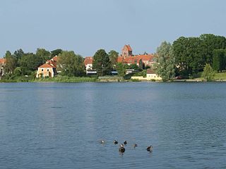
Frederikssund is a Danish town, seat of the Frederikssund Municipality, in the Region Hovedstaden with a population of 17,244. It received the status of market town in 1810. The town is famous for its annual Viking Games as well as for the J.F. Willumsen museum. Since 1935, it has been connected to Hornsherred via the Kronprins Frederik Bridge.
Gentofte is a district of Gentofte Municipality in the northern suburbs of Copenhagen, Denmark. Major landmarks include Gentofte Town Hall, Gentofte Hospital and Gentofte Church. Gentofte Lake with surrounding parkland and nature reserves form the most important greenspace.
Rødovre is a town in eastern Denmark, seat of the Rødovre Municipality, in the Region Hovedstaden. The town's population 1 January 2019 was 39,907, and in addition 145 persons had no fixed address, which made up a total of 40,052 in the municipality as a whole. Rødovre is part of the urban area of Copenhagen.
Lemvig is a market town located on the Limfjord in North Jutland, Denmark. The town has a population of 6,802 (2024), and is the seat of Lemvig Municipality in the North Jutland Region.

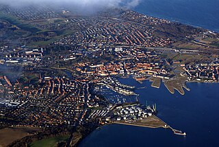
Køge is a seaport on the coast of Køge Bugt 39 km southwest of Copenhagen. It is the principal town and seat of Køge Municipality, Region Sjælland, Denmark. In 2024, the urban area had a population of 38,647.
The Finger Plan is an urban plan from 1947 which provides a strategy for the development of the Copenhagen metropolitan area, Denmark. According to the plan, Copenhagen is to develop along five 'fingers', centred on S-train commuter rail lines, which extend from the 'palm', that is the dense urban fabric of central Copenhagen. In between the fingers, green "wedges" are intended to provide land for agriculture and recreational purposes.
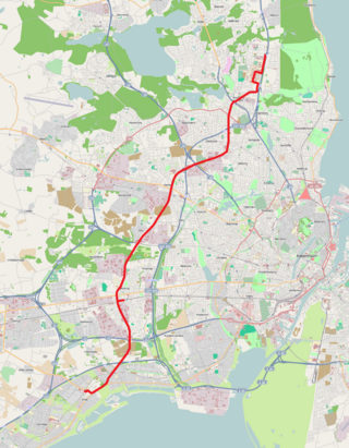
Greater Copenhagen Light Rail is a planned electric light rail system crossing the lines of the S-train in Greater Copenhagen, Denmark, parallel to but outside the borders of Copenhagen Municipality. Its first stage is known as the Ring 3 Light Rail, for which construction started in 2018. It will go from Lundtofte Park north of Copenhagen to Ishøj station in the southwest, and it is expected to open in 2025, with an annual ridership of 13-14 million projected. The line will be owned by the Ringby-Letbanesamarbejdet, which is a collaboration between the municipalities serviced or affected by the line.
Ølstykke-Stenløse is a city located in the Egedal Municipality, in the Capital Region of Denmark. Both Ølstykke and Stenløse has been counted as one city by Statistics Denmark from 1 January 2010, and it forms the eastern part of the city closest to Copenhagen, 25 kilometers in a straight line northwest of City Hall Square, as well as Gammel Ølstykke and Ølstykke Stationsby in the west. It is Denmark's 29th largest city (2024), with a population of 23,344 (2024). It is the largest city in Egedal Municipality and more than half of the municipality's residents live within the city.


